Hilltown Township, Bucks County, Pennsylvania
| Hilltown Township | |
|---|---|
| Township | |
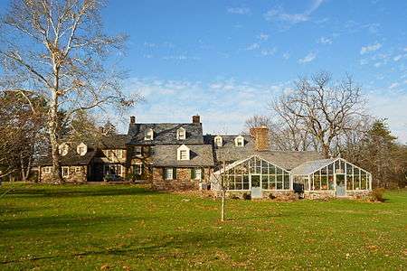 Green Hills, home of Pearl Buck | |
 Location of Hilltown Township in Bucks County | |
 Hilltown Township Location in Pennsylvania and the United States  Hilltown Township Hilltown Township (the US) | |
| Coordinates: 40°22′36″N 75°15′05″W / 40.37667°N 75.25139°WCoordinates: 40°22′36″N 75°15′05″W / 40.37667°N 75.25139°W | |
| Country | United States |
| State | Pennsylvania |
| County | Bucks |
| Area[1] | |
| • Total | 27.03 sq mi (70.01 km2) |
| • Land | 26.97 sq mi (69.84 km2) |
| • Water | 0.07 sq mi (0.17 km2) |
| Elevation | 397 ft (121 m) |
| Population (2010) | |
| • Total | 15,029 |
| • Estimate (2016)[2] | 15,243 |
| • Density | 565.25/sq mi (218.25/km2) |
| Time zone | UTC-5 (EST) |
| • Summer (DST) | UTC-4 (EDT) |
| ZIP code | 18927 |
| Area code(s) | 215 |
| FIPS code | 42-017-34952 |
| Website |
www |
Hilltown Township is a township in Bucks County, Pennsylvania, United States. The population was 15,029 at the 2010 census. Hilltown is part of Pennridge School District.
History
The Uneek Havana Cigar Company at Blooming Glen and Green Hills Farm are listed on the National Register of Historic Places. Green Hills Farm is also designated a National Historic Landmark.[3]
Geography
According to the United States Census Bureau, the township has a total area of 26.9 square miles (70 km2), all of it land. It is located in the Delaware watershed and is drained by the East Branch Perkiomen Creek and Neshaminy Creek.
Its villages include Bean, Bethon, Blooming Glen, Deep Run, Fair Hill, Fricks, Griers Corner (also in Bedminster and Plumstead Townships,) Hilltown, Keystone Point, Kulps Corner (also in Bedminster Township), Leidytown, Line Lexington (also in New Britain Township and Montgomery County,) Loux Corner (Albrights Corner), Mount Pleasant, Naces Corner, New Galena, Pennville, Snoveltown, Thomas Corner, and Unionville (also in Montgomery County).[4]
Natural features in the township include Deep Run, Hardiaken Creek, Mill Creek, Perkiomen Creek (East Branch), and Pleasant Spring Creek.[4]
Neighboring municipalities
- New Britain Township (southeast)
- Plumstead Township (east)
- Bedminster Township (northeast)
- Dublin (northeast)
- East Rockhill Township (north)
- Perkasie (northwest)
- Sellersville (northwest)
- West Rockhill Township (west)
- Telford (west)
- Souderton, Montgomery County (southwest)
- Franconia Township, Montgomery County (southwest)
- Hatfield Township, Montgomery County (south)
Hilltown Township surrounds the borough of Silverdale.
Demographics
| Historical population | |||
|---|---|---|---|
| Census | Pop. | %± | |
| 1930 | 2,808 | — | |
| 1940 | 3,182 | 13.3% | |
| 1950 | 3,688 | 15.9% | |
| 1960 | 5,549 | 50.5% | |
| 1970 | 7,281 | 31.2% | |
| 1980 | 9,326 | 28.1% | |
| 1990 | 10,582 | 13.5% | |
| 2000 | 12,102 | 14.4% | |
| 2010 | 15,029 | 24.2% | |
| Est. 2016 | 15,243 | [2] | 1.4% |
| [5] | |||
As of the 2010 census, the township was 92.7% White, 2.0% Black or African American, 0.1% Native American, 3.1% Asian, 0.1% Native Hawaiian, and 1.3% were two or more races. 2.8% of the population were of Hispanic or Latino ancestry.[6]
As of the census[7] of 2000, there were 12,102 people, 4,275 households, and 3,390 families residing in the township. The population density was 449.7 people per square mile (173.6/km²). There were 4,370 housing units at an average density of 162.4/sq mi (62.7/km²). The racial makeup of the township was 95.94% White, 1.54% African American, 0.09% Native American, 1.08% Asian, 0.02% Pacific Islander, 0.33% from other races, and 0.99% from two or more races. Hispanic or Latino of any race were 1.46% of the population.
There were 4,275 households, out of which 37.5% had children under the age of 18 living with them, 69.1% were married couples living together, 7.0% had a female householder with no husband present, and 20.7% were non-families. 16.4% of all households were made up of individuals, and 6.8% had someone living alone who was 65 years of age or older. The average household size was 2.81 and the average family size was 3.17.
In the township the population was spread out, with 27.2% under the age of 18, 6.1% from 18 to 24, 30.6% from 25 to 44, 24.1% from 45 to 64, and 12.1% who were 65 years of age or older. The median age was 37 years. For every 100 females, there were 97.5 males. For every 100 females age 18 and over, there were 94.4 males.
The median income for a household in the township was $63,178, and the median income for a family was $69,183. Males had a median income of $46,145 versus $30,566 for females. The per capita income for the township was $25,800. About 3.3% of families and 4.1% of the population were below the poverty line, including 4.8% of those under age 18 and 3.6% of those age 65 or over.
Climate
During the summer months, frequent episodes of high humidity occur. Occasionally, heat index values exceed 100 °F (38 °C). On average, the wettest month of the year is July which corresponds with the annual peak for thunderstorm activity. During the winter months, wind chill values occasionally fall below 0 °F (-18 °C). On average, the snowiest month of the year is February which corresponds with the annual peak for nor'easter activity.
| Climate data for Hilltown Township, Pennsylvania (1981 – 2010 averages). Elevation 546 ft. (166 m). | |||||||||||||
|---|---|---|---|---|---|---|---|---|---|---|---|---|---|
| Month | Jan | Feb | Mar | Apr | May | Jun | Jul | Aug | Sep | Oct | Nov | Dec | Year |
| Average high °F (°C) | 37.8 (3.2) |
41.2 (5.1) |
49.5 (9.7) |
61.7 (16.5) |
71.6 (22) |
80.1 (26.7) |
84.2 (29) |
82.6 (28.1) |
75.7 (24.3) |
64.3 (17.9) |
53.4 (11.9) |
42.0 (5.6) |
62.0 (16.7) |
| Average low °F (°C) | 20.2 (−6.6) |
22.4 (−5.3) |
29.2 (−1.6) |
38.9 (3.8) |
48.5 (9.2) |
58.0 (14.4) |
62.8 (17.1) |
61.4 (16.3) |
53.5 (11.9) |
42.0 (5.6) |
33.6 (0.9) |
25.0 (−3.9) |
41.3 (5.2) |
| Average precipitation inches (mm) | 3.41 (86.6) |
2.78 (70.6) |
3.84 (97.5) |
4.05 (102.9) |
4.36 (110.7) |
4.38 (111.3) |
4.86 (123.4) |
3.98 (101.1) |
4.56 (115.8) |
4.27 (108.5) |
3.74 (95) |
3.98 (101.1) |
48.21 (1,224.5) |
| Average snowfall inches (cm) | 9.0 (22.9) |
10.0 (25.4) |
4.3 (10.9) |
0.8 (2) |
0.0 (0) |
0.0 (0) |
0.0 (0) |
0.0 (0) |
0.0 (0) |
0.0 (0) |
0.6 (1.5) |
4.4 (11.2) |
29.1 (73.9) |
| Source: PRISM[8] | |||||||||||||
References
- ↑ "2016 U.S. Gazetteer Files". United States Census Bureau. Retrieved Aug 13, 2017.
- 1 2 "Population and Housing Unit Estimates". Retrieved June 9, 2017.
- ↑ National Park Service (2010-07-09). "National Register Information System". National Register of Historic Places. National Park Service.
- 1 2 MacReynolds, George, Place Names in Bucks County, Pennsylvania, Doylestown, Bucks County Historical Society, Doylestown, PA, 1942, P1.
- ↑ http://www.dvrpc.org/data/databull/rdb/db82/appedixa.xls
- ↑ https://www.usatoday.com/news/nation/census/profile/PA
- ↑ "American FactFinder". United States Census Bureau. Retrieved 2008-01-31.
- ↑
