Highways in Poland


Highways in Poland are public roads designed to carry large amounts of traffic. The public roads in Poland are grouped into four categories related to the republic's administrative division. Motorways and expressways are part of the national road (DK) network. Voivodeship roads (DW) are provincial-level roads administered by the individual governments of the voivodeships. Powiat and gmina roads are administered by county and municipal authorities, and do not have any separate road signs for them, though they do have their respective signature. Poland has 419,636.4 km (260,750 mi) of public roads, of which 128,713.3 km (79,979 mi) are unsurfaced (2015):[1]
- National roads: 19,292.8 km (11,988 mi), 0.2 km (0.12 mi) unsurfaced
- Voivodeship roads: 29,108.6 km (18,087 mi), 52 km (32 mi) unsurfaced
- Powiat roads: 125,092.3 km (77,729 mi), 10,380 km (6,450 mi) unsurfaced
- Gmina roads: 246,142.7 km (152,946 mi), 118,285.1 km (73,499 mi) unsurfaced
Definitions of highways according to Polish law
The 21 March 1985 Public Roads Act, with later amendments, defines the motorways and expressways as follows:
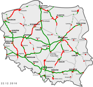
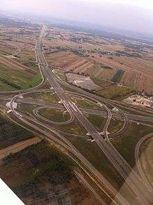
Under current plans, three motorways will have spanned the country by 2022, with two routes running along an east to west axis (A2 running centrally and A4 running southerly) and one motorway traversing a north to south axis (with A1 running centrally). In addition, three shorter motorway stretches, A6, A8, A18 complete the planned motorway network. The only complete motorway stretches are A4 and A8. All others are currently (partially) under construction or in various stages of planning. As of 30 March 2018, 1,703.8 km (1,058.69 mi) of motorways are in use (of which 71.5 km (44.43 mi) one-carriageway). Some motorway stretches are tolled, others (predominantly the bypasses of large cities and newly-opened stretches) are free of charge. Motorways are the only roads in Poland which use blue background on road signs - others use green road signs.

Expressway on-ramp signs in Poland are marked by a white car inside a blue background, while numbered designations are white on a red background, with the letter S preceding the number. Major expressways (in various stages of use, construction, or planning) include S3, S5, S7, S11, S17 and S19 running north to south, and S6, S8, S10, S12 and S74, running east to west. As of 3 July, 1,937.3 km (1,203.78 mi) of expressways are currently in use (of which 248.42 km (154.36 mi) one-carriageway).
Technical parameters
The parameters of these roads are determined by the Ordinance of the Minister of Transport and Maritime Economy of 2 March 1999 - on technical parameters to be met by public roads and their location. Expressways are different from motorways mainly in that they:
- Can have a single carriageway
- Motorways can have interchanges only with main roads. The spacing between nodes should not be less than 15 km, and within borders or near a big city or a group of cities not less than 5 km. In exceptional cases, if necessary for the functional traffic movement, it can be not less than 3 km, but only within or near a large city or in a group of cities. Expressways may have them more often.
- Sometimes have a junction in built-up areas (motorways try to avoid it)
- Is designated for lower speed that the motorway
- Have narrower lanes (emergency lanes can be narrower, too, and they needn't be present at all). Motorways, on the other hand, must have them.
- Expressways have narrower road width (with all structures beside it) than motorways have - 40 m versus 60 m in motorways
- Expressways may built as the upgrade of the national road (voivodership road only in S61). However, most modern projects are built(planned) as a separate road rather than just as an addition of the lanes to the existing one(like S3). Motorways can't be built as the national road upgrade but as a separate road only
Other parameters of the roads:
| projected speed (km/h) | 120 | 100 | 801 | |||
|---|---|---|---|---|---|---|
| the width of the lane (m) | 3,75 | 3,5 | ||||
| width of the emergency lane (m) | 3,0 | 2,5 | ||||
| maximum length of a slope (turn in the tunnel) which don't limit sight | 2000 | 1500 | ||||
| min. length of a straight section between turns on the same side (m) | 500 | 400 | 350 | |||
| min. length of turns (m) | 300 | 200 | 150 | |||
| max. gradient of turn (proc.) | 4 | 5 | 6 | |||
|
Notes: 1 – only inside or near borders of a big city | ||||||
Maximum speeds allowed on highways
| Max. speed (km/h) | |||
|---|---|---|---|
| Vehicle | |||
|
140 | 120 | 100 |
|
100 | 100 | 100 |
|
80 | 80 | 80 |
|
60 | 60 | 60 |
|
40 | 40 | 40 |
| Not allowed on motorways: pedestrians, bikes, mopeds, agricultural vehicles (e. g. tractors and horse carriages). Minimal speed on motorways is 40 km/h unless there are any extraordinary circumstances (e.g. snow, ice or a car broken down). It is forbidden to stop unless in very extraordinary cases and to move back. Towing is not allowed on motorways but is permitted on expressways. Roads are protected from animals crossing the road | |||
The motorways and expressways built before 1999 do not have to fulfill the technical parameters listed in the ordinance. For instance, S3 near Rzęśnica (West Pomeranian voivodership) has at-grade road interchanges, and it does not need to be reconstructed since it was opened in 1979, but it might be reconstructed in the near future, nonetheless .
Tolls

At the moment cars are free of payment while driving on expressways, however A1, A2 and A4 are planned as tolled (some parts are already such). The payments go to the National Roads Fund.
The National Roads Fund pays out money, if the amount of income received by the private concessor is less than was expected by the agreement between the government and the concessor. For example, in 2012 33 million PLN was allocated to private companies because of that.
There are two systems of collecting tolls:
Open system
In this system money is only paid at the toll booths put across the road. There different amount of money is paid according to the type of the vehicle. It is relatively cheap, but it forces drivers to stop at each toll booth, thus lowering the capacity of a motorway. For example, the Greater Poland part of A2 has all of its toll booths spaced approx. 50 km apart.
This system is preferred by private concessors and it operates on the following sections of motorways:
- Krzesiny – Września (37.5 km (23.30 mi)) from 27.11.2003
- Września – Konin (Modła) (47.7 km (29.64 mi)) from 20.12.2002
On A2, both managed by Autostrada Eksploatacja S.A.
- Mysłowice-Brzęczkowice – Balice (61 km) from 3.04.2000
On A4 managed by Stalexport Autostrada Malopolska S.A.
Closed system
Another way to collect money from motorway using is so-called closed system, on which there are toll stations on every interchange both entering and exiting the motorway, as well as toll booths on the motorway, which signifies the end of the concession section. In this case the driver receives a ticket while entering the motorway, which must be kept all the time using the motorway. He pays at either toll station while exiting the motorway or at the toll booth. The amount of money depends not only on the type of the car, but also on the distance driven. It is more expensive at the building and maintenance, as the toll stations have to be built at every interchange. However, it requires fewer toll booths across the motorway, which is a big advantage, as the traffic is free-flowing, and there is less fuel consumption. The queues before the tolls are put off the motorway, and are put onto the exits and interchanges.
The following sections are tolled as of 31 March 2018:
- Motorway A1:
- Rusocin – Swarożyn (24 km (14.91 mi)), from 20.02.2008
- Swarożyn – Nowe Marzy (64 km (39.77 mi)), from 6.01.2009
- Nowe Marzy – Czerniewice (62 km (38.53 mi)), from 11.02.2012
- Motorway A2:
- Motorway A4:
- Bielany Wrocławskie – Gliwice-Sośnica (166 km (103.15 mi)), from 1.06.2012
Free motorways
The motorways that are toll-free, as of 31 March 2018:
- A6, A8 and A18 on the whole length
- A2 on sections:
- A4 on sections:
- Zgorzelec – Bielany Wrocławskie,
- Gliwice-Ostropa – Katowice-Murckowska,
- Between different toll stations at the Gliwice bypass
- Lately finished sections between Kraków-Bieżanów to Korczowa
- A1 on section:
- Toruń-Południe (152nd kilometer) - Piotrków Trybunalski (349th kilometer)
- Pyrzowice (475th kilometer) - Polish-Czech border (568th kilometer)
viaTOLL payment system

From 1.07.2011 all vehicles weighing more than 3.5 tons are obliged to have a special viaTOLL apparatus. On the chosen roads (some motorways, expressways and national roads) the special electronic readers are installed. They connect to the apparatus in the vehicle in a wireless way, and they also count the toll the vehicle has to pay. It is possible to buy it on some petrol stations or at the special points of selling. If the apparatus isn't at the place, fines are applied:
- 1500 PLN if the car is heavier than 12 tons
- 750 PLN if the car is heavier than 3.5 tons but lighter than 12 tons.
Planned Electronical Toll Collection System
In 2014 the Ministry of Infrastructure and Development has uncovered the plans to imply the Electronical Toll Collection System. The new plans were made because of the big problems concerning the Manual Toll Collection System. At the time while there is a huge flow of traffic (especially in the holiday period), there are long queues to the toll booths, which, according to some reports, reached up to 10 km. Drivers in these cases are forced to wait 2 hours to pay the toll at the toll booths. That was the reason the works to construct the toll booths on A4 were suspended, even though there were some stages of construction in progress.
The situation wasn't much relieved even after the toll booths had separated a special lane for those vehicles that have been registered into the ViaAuto system. It came out even worse. A lot of experts tell it is one lane less for those paying traditionally.
At those times a few simple solutions were introduced, for example the cashiers themselves giving the tickets. Next solution came from the Council of Ministers, which claimed that the motorway will be free from the day they gave out the decision (06.08.2014) to the end of the summer holidays (it only concerned the period from 4.00 p.m. on Friday to midnight from Sunday to Monday).
Now the ministry is working on the system new electronic system. According to different concepts, there are two options - either the full liquidation of the toll booths or their reconstruction. The reconstructed toll booths had then the toll applied via the viaTOLL system, so every vehicle must have had the viaTOLL apparatus, as the cars and trucks heavier than 3.5 tons have. Taking into account that not every driver drives regularly on the motorway, there must have been an online registration for light cars introduced. After that, when any car would arrive to such a toll booth, the registration plate will be scanned in order to recognise the car. The implication, however, will become true after signing of agreements with private concessionaires first.
List of Polish motorways and expressways
In May 2004, the Council of Ministers of Poland published the document including the planned highway network, the length of which was about 7,200 km (4,473.87 mi) and contains most of the expressways in plans today. Further cabinet regulations under Prime Minister Jarosław Kaczyński published in February 2007 added S2 and S79 to the network, planned to facilitate high speed traffic in and out of Warsaw.[2] In October 2009, the cabinet under Donald Tusk supplemented plans for the construction of S61 to serve the northeastern region of the country to connect with Lithuania.[3] In September 2015, S16 was announced as the government priority.[4]
In May 2016, next changes were made to the system: S52 created, S16 extended to Białystok, S69 renamed to S1, S1 from Bielsko-Biała to Cieszyn Became S52. Kraków northern bypass became the S52, too. Also Expressway from Bielsko Biała to Kraków will become S52. [5]
As of 30 March 2018, the total planned high-speed way mileage is estimated at 7,943.42 km (4,935.81 mi) (see note 2 in table).
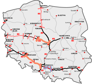
The following table summarizes the planned motorway and expressway network with approximate lengths. As of 21 July 2016, 57.2 km (40 mi) of motorways and 1,110.367 km (689.950 mi) of expressways are in various stages of construction(of which 98.6 km (61.27 mi) single-carriageway construction).[6][7][8]
.jpg)


| Sign | Course | Total length | Existing | In realisation | Of these under active construction | Tender | Environmental decision (DŚU) | |
|---|---|---|---|---|---|---|---|---|
| Gdańsk (S6) – Toruń (S10) - Łódź - Gliwice (A4) - Gorzyczki (border with the Czech Republic) | 566.1 km (351.76 mi) | 431.65 km (268.21 mi) | 76.25% | 52.7 km (32.75 mi) | 81.75 km (50.80 mi) | |||
| Świecko (border with Germany) - Poznań (S5/S11) - Łódź (A1/S14) - Warsaw (S2) – Kukuryki (border with Belarus) | 624.9 km (388.29 mi) | 475 km (295.15 mi) | 76.012% | 14.6 km (9.07 mi) | 135.3 km (84.07 mi) | |||
| Jędrzychowice (border with Germany) – Legnica (S3) - Wrocław (A8) - Opole - Gliwice (A1) - Kraków (S7) - Rzeszów (S19) - Korczowa (border with Ukraine) | 672 km (417.56 mi) | 672 km (417.56 mi) | 100% | |||||
| Kołbaskowo (border with Germany) – Rzęśnica (S3). Szczecin southern bypass | 29 km (18.02 mi) | 24.35 km (15.13 mi) | 83.97% | 4.65 km (2.89 mi) | ||||
| Bielany Wrocławskie (S8) – Wrocław (S8) (Wrocław motorway bypass, AOW) | 22.3 km (13.86 mi) | 22.3 km (13.86 mi) | 100% | |||||
| Olszyna (border with Germany) – Krzyżowa (A4) | 78.5 km (48.78 mi) | 7 km (4.35 mi); 71.5 km (44.43 mi) (north carriageway) |
54.46% | 71.5 km (44.43 mi) (south carriageway) | ||||
| In total | 1,992.9 km (1,238.33 mi) | 1,632.3 km (1,014.26 mi)+71.5 km (44.43 mi) 1st carriageway | 83.6996% | 71.95 km (44.71 mi) | 57.35 km (35.64 mi) | 81.75 km (50.80 mi) | 135.3 km (84.07 mi)+71.5 km (44.43 mi) 2nd carriageway | |
| Sign | Course | Total length | Existing | In realisation | Of these under active construction | Tender | Environmental decision (DŚU) | |
| Pyrzowice (A1) – Mysłowice (A4) - Bielsko-Biała - Zwardoń (border with Slovakia) | 129.4 km (80.41 mi) | 59 km (36.66 mi)+25.92 km (16.11 mi) 1st carriageway | 55.611% | 5 km (3.11 mi)+13.26 km (8.24 mi) 2nd carriageway | 47.46 km (29.49 mi) | |||
| Konotopa (A2) – Nowy Konik (A2)
Warsaw southern bypass |
34.1 km (21.19 mi) | 15.45 km (9.60 mi) | 45.308% | 18.65 km (11.59 mi) | ||||
| Świnoujście (border with Germany) - Szczecin (A6) - Gorzów Wielkopolski - Jordanowo (A2) - Zielona Góra - Lubin - Legnica (A4) – Lubawka (border with the Czech Republic) | 472.59 km (293.65 mi) | 219.27 km (136.25 mi)+38.6 km (23.98 mi) 1st carriageway | 50.481% | 141.54 km (87.95 mi)+31.1 km (19.32 mi) 2nd carriageway | 116.04 km (72.10 mi)+31.1 km (19.32 mi) 2nd carriageway | 31.38 km (19.50 mi) | ||
| Ostróda (S7) - Grudziądz (A1) - Bydgoszcz (S10) - Gniezno - Poznań (A2) - Leszno – Wrocław (A8) | ca. 460 km (285.83 mi) | 138.9 km (86.31 mi)+22 km (13.67 mi) 1st carriageway | 32.6% | 183.83 km (114.23 mi)+22 km (13.67 mi) second carriageway | ca. 4.5 km (2.80 mi) | |||
| Szczecin (A6) - Goleniów (S3) - Koszalin (S11) - Słupsk – Gdańsk (A1) | 408.72 km (253.97 mi) | 24.2 km (15.04 mi)+15.2 km (9.44 mi) 1st carriageway | 7.780% | 157.82 km (98.06 mi) | 135.02 km (83.90 mi) | 143.1 km (88.92 mi)+15.2 km (9.44 mi) 2nd carriageway | 68.4 km (42.50 mi) | |
| Gdańsk (A1) - Elbląg (S22) - Olsztynek (S51) - Warsaw - Radom (S12) - Kielce (S74) - Kraków – Rabka-Zdrój | 713.67 km (443.45 mi) | 373.4 km (232.02 mi)+0.5 km (0.31 mi) 1st carriageway | 52.356% | 227.57 km (141.41 mi)+0.5 km (0.31 mi) 2nd carriageway | 113.05 km (70.25 mi)+0.5 km (0.31 mi) 2nd carriageway | 18.3 km (11.37 mi) | 48 km (29.83 mi) | |
| Wrocław (A8) - Łódź (A1) - Piotrków Trybunalski - Warsaw - Ostrów Mazowiecka (S61) - Białystok (S19) | 527.52 km (327.79 mi) | 466.33 km (289.76 mi) | 88.400% | 61.19 km (38.02 mi) | ||||
| Szczecin (A6) – Piła (S11) - Bydgoszcz (S5) - Toruń (A1) - Płock - Nowy Dwór Mazowiecki (S7)-Wola Rasztowska(S8) | ca. 515 km (320.01 mi) | 32.03 km (19.90 mi)+24.5 km (15.22 mi) 1st carriageway | 8.6% | 25.9 km (16.09 mi)+6.4 km (3.98 mi) 2nd carriageway | 25.9 km (16.09 mi) | |||
| Koszalin (S6) - Piła (S10) - Poznań (A2/S5) - Ostrów Wielkopolski - Kępno (S8) - Tarnowskie Góry - A1 | ca. 560 km (347.97 mi) | 47.5 km (29.52 mi)+8.6 km (5.34 mi) 1st carriageway | 9.25% | 20.5 km (12.74 mi)+4 km (2.49 mi)2nd carriageway | 17.5 km (10.87 mi) | 71.5 km (44.43 mi)+6.5 km (4.04 mi) 2nd carriageway | ||
| Piotrków Trybunalski (A1) – Sulejów (S74) - Radom (S7) - Puławy - Lublin (S17/S19) - Chełm -Dorohusk (border with Ukraine) | 319.7 km (198.65 mi) | 74.6 km (46.35 mi)+8.5 km (5.28 mi) 1st carriageway | 24.664% | 11.8 km (7.33 mi) | 74.6 km (46.35 mi) | |||
| S8 - Pabianice - Konstantynów Łódzki - Aleksandrów Łódzki - Zgierz - A2
Western Łódź bypass |
41.4 km (25.72 mi) | 12.9 km (8.02 mi) | 31.160% | 28.5 km (17.71 mi) | ||||
| Olsztyn(S51) - Ełk (S61) - Białystok (S19) | ca. 249 km (154.72 mi) | 15.6 km (9.69 mi)+15.5 km (9.63 mi) 1st carriageway | 9.377% | 14.7 km (9.13 mi) | 30.1 km (18.70 mi)+15.5 km (9.63 mi)2nd carriageway | |||
| Warszawa (S8) – Lublin (S12/S19) - Zamość - Hrebenne (border with Ukraine) | 322.3 km (200.27 mi) | 82.2 km (51.08 mi) | 25.504% | 100.054 km (62.17 mi)+9.58 km (5.95 mi) 1-carriageway | 86.854 km (53.97 mi) | 105.92 km (65.82 mi) | ||
| Kuźnica Białostocka (border with Belarus) – Białystok (S8) - Lublin (S12/S17) - Stalowa Wola - Rzeszów (A4) - Barwinek (border with Slovakia) | 594.7 km (369.53 mi) | 32.8 km (20.38 mi)+26 km (16.16 mi) 1st carriageway | 7.701% | 77 km (47.85 mi) | 54.2 km (33.68 mi) | 212.35 km (131.95 mi) | ||
| Elbląg – Grzechotki (border with Russia, Kaliningrad oblast) | 48.6 km (30.20 mi) | 48.6 km (30.20 mi) 1 carriageway | 50% | |||||
| Olsztyn – Olsztynek (S7) | 18.5 km (11.50 mi) | 18.5 km (11.50 mi) | 100% | |||||
| Part 1. Kraków northern bypass (POK)
Part 2. Beskidzka Droga Integracyjna: Głogoczów (DK7) - Wadowice - Bielsko-Biała (S1) - Skoczów - Cieszyn (border with the Czech Republic) |
122.1 km (75.87 mi) | 42.3 km (26.28 mi) | 31.777% | 12.55 km (7.80 mi)+2.33 km (1.45 mi) to upgraded | 67.25 km (41.79 mi) | |||
| Ostrów Mazowiecka (S8) - Łomża - Ełk (S16) - Suwałki – Budzisko (border with Lithuania) | 209.92 km (130.44 mi) | 16 km (9.94 mi)+14.5 km (9.01 mi) 1st carriageway | 8.657% | 103.5 km (64.31 mi)+14.5 km (9.01 mi) 2nd carriageway | 12.8 km (7.95 mi) | 75.92 km (47.17 mi) | ||
| Sulejów (S12) - Kielce (S7) - Sandomierz – Nisko (S19) | 192.2 km (119.43 mi) | 6.8 km (4.23 mi) | 3.538% | 76.3 km (47.41 mi) | ||||
| Warszawa-Lotnisko (S2) – Warszawa-Marynarska | 4.3 km (2.67 mi) | 4.3 km (2.67 mi) | 100% | Notes: 1) S16 is not signed as an expressway.
2) Some sections (like S12/S17/S19 on Lublin bypass) overlap. This is true as well for: S5/S10 in Bydgoszcz, S1/S52 near Bielsko-Biała, and S7/S10 in Nowy Dwór Mazowiecki. The table shows data with overlapping sections, i.e. Lublin bypass section is counted for all S12/S17/S19. | ||||
| Katowice (Roździeńskiego interchange)-Sosnowiec (Pogoń interchange) | 6.8 km (4.23 mi) | 6.8 km (4.23 mi) | ||||||
| In total[7][8][10] | 5,950.52 km (3,697.48 mi)±10 km (6.21 mi) | 1,688.88 km (1,049.42 mi)+248.42 km (154.36 mi) 1st carriageway | 30.4694% | 1,144.054 km (710.882 mi)+88.08 km (54.73 mi) 2nd carriageway | 778.684 km (483.85 mi)+53.6 km (33.31 mi) 1 carriageway | 371.59 km (230.90 mi)+28.46 km (17.68 mi) 1 carriageway | 806.38 km (501.06 mi)+22 km (13.67 mi) 2nd carriageway | |
| Kind of highway | Planned mileage | Done | In percentage | In realisation(building) | Of which in active building | Tendered | With DŚU |
|---|---|---|---|---|---|---|---|
| Motorways | 1,992.9 km (1,238.33 mi) | 1,632.3 km (1,014.26 mi)+71.5 km (44.43 mi) 1st carriageway | 83.6996% | 71.95 km (44.71 mi) | 57.35 km (35.64 mi) | 81.75 km (50.80 mi) | 135.3 km (84.07 mi)+71.5 km (44.43 mi) 2nd carriageway |
| Expressways | 5,950.52 km (3,697.48 mi)±10 km (6.21 mi) | 1,688.88 km (1,049.42 mi)+248.42 km (154.36 mi) 1st carriageway | 30.4694% | 1,144.054 km (710.882 mi)+88.08 km (54.73 mi) 2nd carriageway | 778.684 km (483.85 mi)+53.6 km (33.31 mi) 1 carriageway | 371.59 km (230.90 mi)+28.46 km (17.68 mi) 1 carriageway | 806.38 km (501.06 mi)+22 km (13.67 mi) 2nd carriageway |
| Total | 7,943.42 km (4,935.81 mi)±10 km (6.21 mi) | 3,321.18 km (2,063.69 mi)+319.92 km (198.79 mi) 1st carriageway | 43.8242%1 | 1,216.004 km (755.59 mi)+88.08 km (54.73 mi) 1 carriageway | 836.034 km (519.49 mi)+53.6 km (33.31 mi) 1 carriageway | 453.34 km (281.69 mi)+28.46 km (17.68 mi) 1 carriageway | 941.68 km (585.13 mi)+93.5 km (58.10 mi) 2nd carriageway |
History

Before World War II
The first plans of creation of a national highway network in Poland were conceived in the interwar period. The main promoter of this concept was Professor Melchior Wladyslaw Nestorowicz of the Warsaw University of Technology, who organized three Road Congresses, during which a group of specialists discussed the creation of the network. On March 5, 1939, in the trade magazine Drogowiec, Professor Nestorowicz proposed a very ambitious plan for the construction of almost 5,000 kilometres of category I and II roads, based on similar programmes in Germany and Italy.[9] Nestorowicz sketched a map of the future system with the following routes:
First class roads would, according to the plans, consist of the following motorways (totalling some 2,500 km (1,553.43 mi):
- Warsaw - Łódź - 100 km
- Warsaw – Poznań - Polish-German border - 350 km
- Warsaw beltway - 130 km
- Poznań beltway - 80 km
- Gdynia – Bydgoszcz – Łódź – 500 km
- Łódź beltway - 90 km
- Bytow - Free City of Danzig border - 50 km
- Katowice – Kraków – Lwów - 375 km
- Warsaw – Lublin - Lwów – Sniatyn - Polish-Romanian border - 550 km
- Puławy – Sandomierz – Przemyśl - 175 km
Second class roads would consist of the following motorways, totalling another 2,295 km (1,430 mi):
- Piotrków Trybunalski - Kielce - Sandomierz - 180 km
- Warsaw – Kielce – Kraków - 180 km
- Łódź - Kalisz - Polish-German border north of Wrocław - 130 km
- Warsaw – Grodno – Vilnius – Polish - Lithuania - Latvian border near Daugavpils - 575 km
- Grodno - Nowogrodek - Polish-Soviet border near Minsk - 190 km
- Bydgoszcz – Poznań – Częstochowa - 350 km
- Katowice – Cieszyn – Polish-Czechoslovak border - 60 km
- Ostrołęka - Polish-East Prussian border - 50 km
- Grodno - Polish-Lithuanian border - 40 km
- Grodno - Brzesc nad Bugiem - Krasnystaw - 300 km
- Warsaw – Brzesc nad Bugiem - 170 km
At the same time the fascist Germany started the construction of parts of their motorway system that exists today as S22(the motorway to Konigsberg), A18 and A4 to Wroclaw(Breslau), as well as the A6 motorway as the Szczecin bypass(the same road to Konigsberg). Those were all completed by 1938.
The World War II warfare expenses meant little money would be invested into any infrastructure of the occupied Poland. Only the piece of what is now A4 motorway near the GOP was constructed.
Given to the usage till 1972(Date shown: DD.MM.YYYY)
| Signature | Section | Length | Date of the beginning of construction | Date of opening | Notes |
|---|---|---|---|---|---|
| Krzywa-Bielany Wrocławskie | 91 km (56.54 mi) | 1934 | 27.09.1936 | ||
| Krzywa-Krzyżowa | 12.3 km (7.64 mi) | 17.10.1937 | |||
| Bielany-Wrocławskie-Brzeg(Owczary) | 34.1 km (21.19 mi) | 1938 | Southern carriageway only | ||
| Ujazd(Nogowczyce)-Łany | 9.1 km (5.65 mi) | 1940 | 1942 | ||
| Łany-Kleszczów | 8.8 km (5.47 mi) | 1936 | 1938 | ||
| 2.6 km (1.62 mi) | 1934 | 27.09.1936 | |||
| Szczecin-Zachód-Rzęśnica | 26.6 km (16.53 mi) | 1938 | |||
| Krzyżowa-Golnice(bridge over Bóbr) | 5.9 km (3.67 mi) | 1936 | 1938 | Modernized in 1993-1995 | |
| Krzyżowa-Iłowa | 37.9 km (23.55 mi) | 1935 | 17.10.1937 | Southern carriageway only | |
| Iłowa-Olszyna | 37.2 km (23.12 mi) | 1936 | 1938 | ||
| Elbląg-Grzechotki | 51.4 km (31.94 mi) | 1934 | |||
| Total | 189.8 km (117.94 mi)+127.1 km (78.98 mi) first carriageway | Note: Signature of the roads at the time of opening was different. | |||
After 1945
Situation
The Potsdam conference defined the new borders for Poland, which were completely different from the 1939 ones. It received the so-called Regained Territories from the former Third Reich with the following parts of motorways (some with one carriageway only, some destroyed because of the warfare):
- "Berlinka" (the road to Konigsberg (Kaliningrad)) at the sections between Kołbaskowo and Łęczyca(now A6 and DW142) and between Elbląg and Grzechotki(now S22), in total 106 km
- Silezian, between Olszyna and Brzeg(now A18 and A4, ca. 220 km) and the Ujazd-Gliwice-Zabrze part (about 40 km, now DK88)
Most of the motorway bridges were destroyed by the armies, but only a few were repaired or rebuilt in the first post-war years. The bridge over Ina river was reconstructed in 1972, and those on S22 only between 1996 and 2003.
Apart from the bridges, almost all the motorways and expressways were left in the same condition as they were in 1945 until the mid-1990s. The only road left from Nazi times that was completed by the People's Republic of Poland(PRP) was a one-carriageway small section between Łęczyca and Lisowo (15 km of what is now DW142) in the powiat stargardzki, which was built on the previous works of Nazis.
Plans
At the post-war year there were very ambitious plans to make a motorway network for the whole Poland. For example, engineer Eugeniusz Buszma has published his propositions to the network in the magazine "Drogowiec" (1946, issue 1):
- East – West (Słubice – Warsaw – Białystok) – 680 km
- North – South (Gdynia – Warsaw – Balkans) – 650 km
- Silesia – Baltic I (Gdańsk – Łódź – Katowice) – 460 km
- Pomeranian (Gdańsk – Szczecin) – 280 km
- Silesian (Wrocław – Katowice – Kraków) – 190 km
- Mazurian (Kaliningrad – Elbląg – Malbork) – 20 km
- Silesia – Baltic II (Bydgoszcz – Wrocław) – 260 km
- Łódź – Wrocław – (Prague) – 310 km
- Katowice – (Vienna) – 60 km
- Poznań – Szczecin – 200 km
- Radom – Lublin – (Lviv) – 220 km
In total, the mileage, according to the proposal, would total more than 3,300 km (2,050 mi).
After the addition of the sections built by the Third Reich the total network length had to be ca. 3700 km. In 1963 the Motorization Council at the Council of Ministers had prezented the similar plan plus the motorways: Warsaw-Kraków-Zakopane, Kraków-Przemyśl, Warsaw-Bydgoszcz-Koszalin, Poznań-Koszalin i Warsaw-Terespol (ca. 1250 km). None of those plans were realized, however.
Despite announcing such pompous plans, no motorway was opened in the meantime.
In the 1970s
Only in the 1970s did any works start. In 1972 it was planned to build:
- the Gliwice-Kraków motorway (now A4)
- The second carriageway of the Wrocław-Gliwice motorway (also A4)
- the Warsaw-Katowice motorway (so-called "Gierkówka", now the S8/A1 road), in the near future
The plans were expanded in 1976 by the following sections:
- Tarnów – Kraków (now A4),
- Eastern GOP (Górnośląski Okręg Przemysłowy) bypass (now S1, northern part),
- Bielsko-Biała – Cieszyn (now S1, southern part),
- Warszawa – Poznań (so-called Olimpijka, now A2),
- Łódź – Piotrków Trybunalski (now A1).
Motorways opened in the 1970s:
| Signation | Section | Length | Date of the beginning of construction | Date of opening |
|---|---|---|---|---|
| Obwodnica Trójmiasta(eastern carriageway)(to Rusocin) | 37.7 km (23.43 mi) | 1973 | 1977 | |
| Rzęśnica-Goleniów | 19.3 km (11.99 mi) | 1976 | 1979 | |
| Total | 57 km (35.42 mi) |
In the 1980s
In the 1980s the really first period of massive construction started.
In 1985 the government already planned to build the expressways apart from the motorways. The only roads left as motorways were A1, A2 and A4.(A6 to Rzęśnica and A18 were signed as motorways as they were built by the motorway standards in the 1930s). The realization of these plans however came at a very slow pace. In the 1980s only the following sections of motorways were given to use: Jaworzno(Byczyna)-Kraków(Balice I) of A4(35.7 km (22.18 mi)), Września-Konin(Modła) of A2(49.2 km (30.57 mi)) and Tuszyn-Piotrków-Trybunalski of A1(16.1 km (10.00 mi)).
Motorways opened in 1980s
| Signation | Section | Length | Date of beginning of the construction | Date of opening | Notes |
|---|---|---|---|---|---|
| Tuszyn-Piotrków Trybunalski | 16.1 km (10.00 mi) | 1978 | 18.12.1989 | DŚU issued for reconstruction | |
| Września-Sługocin (Golina) | 35.7 km (22.18 mi) | 1977 | 9.10.1985 | ||
| Sługocin-Konin West (Modła) | 13.5 km (8.39 mi) | 1986 | 10.11.1988 | ||
| Chrzanów-Kraków (Balice I) | 29.6 km (18.39 mi) | 1976 | 3.01.1983 | ||
| Chrzanów-Jaworzno (Byczyna) | 6.1 km (3.79 mi) | 1978 | 22.11.1986 | ||
| Kraków (Balice I)-Kraków (Tyniec) | 7.8 km (4.85 mi) | 1979 | 8.12.1988 | ||
| Dąbrowa Górnicza-Tychy | 34.7 km (21.56 mi) | 1978 | 1983 | After completion of Lędziny-Biesko-Biała section of S1 the Lędziny-Tychy road will be signed as S1A | |
| Obwodnica Trójmiasta (to Straszyn) | 32.4 km (20.13 mi) | 1978 | 1984 | Only western carriageway | |
| Kielce bypass | 22.9 km (14.23 mi) | 1974 | 1984 | Only eastern carriageway | |
| Katowice (węzeł Roździeńskiego)-Sosnowiec (węzeł Pogoń) | 6.8 km (4.23 mi) | 1978 | 1985 | First completely done expressway | |
| Total | 150.3 km (93.39 mi)+55.3 km (34.36 mi) single carriageway | ||||
In the 1990s
In the III Rzeczpospolita the plans started to change again. The following expressways were promoted to motorway standards, temporarily however: A3 on the planned length became S3, and A8 was shortened to the Wrocław bypass instead of the Łódź-Wrocław-Bolków motorway, in 2001, There are some changes that survived, however: the Szczecin bypass(A6) and the Krzywa-Olszyna roads were promoted to motorways at that time, and still are ones. The signage of Krzywa-Olszyna section was A12, however, instead of the A4 at Krzywa-Krzyżowa and A18 at Krzyżowa-Olszyna.
Motorways opened in the 1990s:
| Signation | Section | Length | Date of beginning of the construction | Date of opening | Notes |
|---|---|---|---|---|---|
| Mysłowice (Brzęczkowice)-Jaworzno(Byczyna) | 15.9 km (9.88 mi) | 1986 | 29,11,1990 | Northern carriageway only | |
| 4.09.1991 | Southern carriageway only | ||||
| Kraków (Tyniec)-Kraków (Sidzina) | 3.5 km (2.17 mi) | 1988 | 1993 | ||
| Jędrzychowice |
1.8 km (1.12 mi) | 1992 | 15.07.1994 | ||
| Kraków Skawina (Sidzina)-Kraków (ul.Kąpietowa) | 5.4 km (3.36 mi) | 1993 | 27.10.1995 | A4 had a crossroads with ul. Kąpielowa(ca. 750 m (820.2 yd) from Kraków Zakopiańska) till 2002, when the bridge was built over it. | |
| Katowice Francuska-Mysłowice (Brzęczkowice) | 11.1 km (6.90 mi) | 1989 | 30.10.1996 | ||
| Katowice Mikołowska-Katowice Francuska | 1.9 km (1.18 mi) | ? | 10.11.1999 | ||
| Olszyna |
9.6 km (5.97 mi) | 1993 | Northern carriageway only, southern renovated to Olszyna interchange(350 m (382.76 yd)) | ||
| Krzyżowa-Golnice | 5.9 km (3.67 mi) | 1995 | Modernized both carriageways | ||
| Cieszyn |
5.2 km (3.23 mi) | 1991 | 1995 | ||
| Sulechów-Zielona Góra (Niedoradz) | 26.8 km (16.65 mi) | 1985 | 1995 | Western carriageway only | |
| Świecie (West)-Świecie (North) | 7 km (4.35 mi) | ? | 1996 | Single carriageway only, 6.9 km (4.29 mi) were built as double carriageway(mostly near the interchanges) | |
| Świecie (West)-Świecie (South) | 6 km (3.73 mi) | 1996 | 1998 | ||
| Zakroczym-Czosnów (Nowy Dwór Mazowiecki bypass) | 14.6 km (9.07 mi) | 1990 | 1999 | ||
| Miłomłyn North-Miłomłyn South | 5.1 km (3.17 mi) | 1995 | 1997 | Single carriageway only | |
| Radzymin North-Radzymin South | 8.15 km (5.06 mi) | 1996 | 1998 | ||
| Total | 74.8 km (46.48 mi)+47.6 km (29.58 mi) single carriageway+5.9 km (3.67 mi)modernized+350 m (382.76 yd) single carriageway modernized | ||||
At the beginning of the new millennium
Before Poland received the EU membership
A few years before Poland entered the EU the tempo of motorway construction increased significantly. The main focus was yet on the east-west motorway A4, although the A2 around Poznań was built, too. Thanks to that by 2005 there was a direct motorway connection to Kraków from Berlin. It was the time when most of the bridges that the World War II destroyed were rebuilt or renovated, especially on A4. However, the pieces of the motorways couldn't have been yet called a network, as only A4 could have been considered as an intercity highway, as it was in 2004. The rest of the highways built were mostly the bypasses of cities. These years started the focus to build comfortable and quick connections between cities. This is also a period when Poland started introducing motorway tolls, as it happened in 2000 with the A4 section between Mysłowice and Kraków(Balice I).
Motorways opened in 2000-1.05.2004
| Signation | Section | Length | Date of beginning of the construction | Date of opening | Notes |
|---|---|---|---|---|---|
| Poznań Komorniki-Poznań Krzesiny | 11.2 km (6.96 mi) | 1998 | 13.09.2003 | ||
| Poznań Krzesiny-Września | 37.3 km (23.18 mi) | 2002 | 27.11.2003 | ||
| Bielany Wrocławskie-Brzeg (Owczary) | 34.1 km (21.19 mi) | 1997 | 16.12.2000 | North carriageway built | |
| Brzeg (Owczary)-Przylesie | 6.6 km (4.10 mi) | ||||
| Prądy-Dąbrówka Górna | 21.4 km (13.30 mi) | ||||
| Przylesie-Prądy | 28.6 km (17.77 mi) | 30.09.2000 | |||
| Dąbrówka Górna-Nogowczyce | 34.3 km (21.31 mi) | 26.07.2001 | |||
| Nogowczyce-Kleszczów | 17.9 km (11.12 mi) | 2001 | 4.12.2003 | South carriageway built | |
| ul.Kąpielowa-Kraków (Wielicka) | 1.1 km (0.68 mi) | ? | 19.12.2002 | ||
| 3.09.2003 | North carriageway built | ||||
| Śmigiel bypass | 4.1 km (2.55 mi) | 2002 | One carriageway only | ||
| Straszyn-Pruszcz Gdański (Rusocin) | 5.4 km (3.36 mi) | 2000 | 2001 | Second carriageway built | |
| Białobrzegi bypass | 7.7 km (4.78 mi) | 2001 | 2003 | ||
| Podborze-Brok | 7.6 km (4.72 mi) | 2000 | |||
| Total | 173.7 km (107.93 mi)+61.5 km (38.21 mi) one carriageway | ||||
Poland in EU
1 May 2004 was a crucial day for the history of motorway construction, and that is when the highway boom started. The main advantage of signing the document is that Poland from the day on request money from the funds in the European Union, so the money could help build, renovate and upgrade the existing road infrastructure(and not only). Under the government of Prime Minister Marek Belka, the Council of Ministers regulations issued in May 2004 detailed plans for a network of motorways and expressways totaling to 7,200 km (4,473.87 mi) across the republic, including 2,033 km (1,260 mi) of designated motorways (A1, A2 (at that times the S2 section was planned as A2), A4, A6, and A18), and the rest being the expressways (S1, S3, S5, S6, S7, S8, S9 (now S19), S10, S11, S12, S14, S17, S22, S51, S69, and S74).[10] S86 existed, but it was not shown in the legal documents until 2015 as part of network. That plan is now the basis of the whole highway network, with only small amendments added in later years.
The current planned network consists of six motorways (A1, A2, A4, A6, A8, A18) and 21 expressways (S1-S3, S5-S8, S10-12, S14, S16, S17, S19, S22, S51-52, S61, S74, S79 and S86).[3]
Motorways opened from 1.05.2004 to 31.10.2009
| Signation | Section | Length | Date of beginning of the construction | Date of opening | Notes |
|---|---|---|---|---|---|
| Rusocin-Swarożyn | 24.2 km (15.04 mi) | 2005 | 2007 | ||
| Swarożyn-Nowe Marzy | 64.7 km (40.20 mi) | 2008 | |||
| Sośnica-Bełk | 15.6 km (9.69 mi) | 22.01.2007 | 20.10.2009 | ||
| Bełk-Świerklany | 14.3 km (8.89 mi) | 7.08.2008 | 2009 | ||
| Kleszczów-Sośnica | 19.1 km (11.87 mi) | 2003 | October 2005 | ||
| Wieliczka-Targowisko | 19.5 km (12.12 mi) | 2007 | 2009 | ||
| Miłówka-Szare | 2.9 km (1.80 mi) | 30.06.2004 | 14.11.2006 | Single carriageway | |
| Szare-Laliki | 4.9 km (3.04 mi) | 26.10.2007 | 18.11.2009 | ||
| Laliki-Zwardoń | 1.8 km (1.12 mi) | 12.06.2007 | 26.12.2008 | ||
| Zwardoń-border with Slovakia |
1.4 km (0.87 mi) | 15.11.2002 | 22.12.2004 | ||
| Gorzów Wielkopolski bypass
(Gorzów Połusnie i/c-Sułęcińska str.) |
2.38 km (1.48 mi) | 2003 | 2004 | Single carriageway | |
| Gorzów Wielkopolski bypass
(Sułęcińska str.-Gorzów-Północ (Małyszyn)) |
9.47 km (5.88 mi) | 2005 | 2007 | ||
| Międzyrzecz bypass | 6.37 km (3.96 mi) | 2004 | 2006 | ||
| Nowa Sól bypass | 18 km (11.18 mi) | 2006 | 2008 | ||
| Szubin bypass | 4.5 km (2.80 mi) | 2004 | 2006 | ||
| Jędrzejów bypass | 5.8 km (3.60 mi) | 2003 | 2005 | 3.1 km (1.93 mi) double-
carriageway; rest single carriageway | |
| Myślenice-Lubień | 16.2 km (10.07 mi) | 2004 | 2009 | ||
| Nowy Dwór Gdański bypass | 2.5 km (1.55 mi) | 2005 | 2007 | ||
| Elbląg southern bypass | 4.2 km (2.61 mi) | ||||
| Płońsk bypass | 4.7 km (2.92 mi) | 28.09.2007 | 03.06.2009 | ||
| Grójec bypass | 8.3 km (5.16 mi) | 18.10.2006 | 19.09.2008 | ||
| Białobrzegi-Jedlińsk | 15.7 km (9.76 mi) | 06.07.2006 | 30.06.2008 | ||
| Kielce bypass (northern part) | 7.1 km (4.41 mi) | 2007 | 2009 | ||
| Oleśnica bypass | 7.21 km (4.48 mi) | 2004 | 2006 | ||
| Wyszków bypass | 12.8 km (7.95 mi) | 27.02.2006 | 14.11.2008 | ||
| Wyszków-Radzymin | 17.3 km (10.75 mi) | 08.12.2006 | 31.07.2009 | ||
| Bielsko-Biała (Komorowice)-Jasienica | 9.5 km (5.90 mi) | 4.06.2003 | 27.10.2006 |
Total length of motorways and expressways in Poland (end of the year)[11]
1936 – 95 km [12]
1937 – 133 km [12]
1938-1945 – 133 km [12]
1945-1976 - 133 km
1977 – 169 km
1978 – 169 km
1979 – 190 km
1980 – 190 km
1981 – 190 km
1982 – 190 km
1983 – 255 km
1984 – 278 km
1985 – 321 km
1986 – 327 km
1987 – 327 km
1988 – 348 km
1989 – 366 km
1990 – 381 km
1991 – 399 km
1992 – 399 km
1993 – 403 km
1994 – 405 km
1995 – 440 km
1996 – 453 km
1997 – 456 km
1998 – 490 km
1999 – 502 km
2000 – 592 km
2001 – 630 km
2002 – 639 km
2003 – 727 km
2004 – 781 km
2005 – 848 km
2006 – 1013 km
2007 – 1083 km
2008 – 1282 km
2009 – 1454 km
2010 – 1560 km
2011 – 1865 km
2012 – 2495 km
2013 – 2805 km
2014 – 3100 km
2015 – 3131 km
2016 – 3252 km
2017 – 3510 km
2018 – 3937 km (forecast)
2019 – 4407 km (forecast)
2020 – 4538 km (forecast)
2021 – 5193 km (forecast)
2022 – 5401 km (forecast)
2023 – 5755 km (forecast)
2024 – 6038 km (forecast)
2025 – 6145 km (forecast)
20?? - 7947,92 km (year unknown; forecast; according to plans)
Notes
Information in the tables given as of 30.03.2018.
1-One carriage highways accounted as half-length in percentages
See also
References
- ↑ GUS. "Transport - wyniki działalności w 2016 r." stat.gov.pl (in Polish). Retrieved 2018-03-30.
- ↑ Dz.U. 2007 nr 35 poz. 220(in Polish)
- 1 2 Dz.U. 2009 nr 187 poz. 1446(in Polish)
- ↑ "S16 na priorytetowej liście Rządu". olsztyn.tvp.pl. Retrieved 2015-10-05.
- ↑ "Zmiany w rozporządzeniu w sprawie sieci autostrad i dróg ekspresowych - Ministerstwo Infrastruktury i Budownictwa". mib.gov.pl. Retrieved 2016-07-05.
- 1 2 "Strona główna :: Generalna Dyrekcja Dróg Krajowych i Autostrad - Serwis informacyjny". www.gddkia.gov.pl/pl/1077/mapa-stanu-budowy-drog. Retrieved 2015-10-05.
- 1 2 "OpenStreetMap". www.openstreetmap.org. Retrieved 2015-10-05.
- 1 2 "Mapa autostrad i dróg ekspresowych w Polsce - SISKOM & SSC". ssc.siskom.waw.pl. Retrieved 2015-10-05.
- ↑ Prof. M. W. Nestorowicz, Problem budowy dróg samochodowych (autostrad) w Polsce
- ↑ Dz.U. 2004 nr 128 poz. 1334(in Polish)
- ↑ http://mib.gov.pl/files/0/1796809/RMUchwala1052017.pdf
- 1 2 3 Then Nazi Germany
External links
| Wikimedia Commons has media related to Highways in Poland. |
- General Directorate for National Roads and Motorways (in Polish, some information also in English)