Roads in Ukraine

Roads in Ukraine (Ukrainian: Авто(мобі́льні) шляхи України, Автошляхи) is a network of automobile roads that includes various types of roadways. The roads are usually categorized into general (public) use, streets and roads within populated areas (i.e. cities/villages), and other including official, private, and special use. The general use roadways are the main traveling routes and some are part of the E-road network. High-speed highways, however, such as motorways or freeways are rare and only available on selected segments of major routes.
The Ukraine's network of roadways was inherited from the Ukrainian SSR, which was part of the bigger Soviet network of roadways. The network consists 99% of roads for public use with 12% assigned as of state importance and 87% - local importance. The whole network of all automobile roads (roadways) consists of some 172,400 km (107,100 mi) out which 164,100 km (102,000 mi) - have hard surface or 95.19%. The existing road network was mostly built in the 1960s and 1970s. For comparison in 1940 the highway network of Ukraine consisted of 270,700 kilometers which only 10.8% contained a paved surface.
Following a big construction project of national roads that started out in preparation to a sport event known as Euro 2012, conditions of roads in Ukraine according to some reports indicate that those roads could be among the worst in Europe.[1] There are some roads that have not been fixed since the fall of the Soviet Union.[1] Some critics point out that not only road conditions, but the road safety is in complete disarray and the level of police corruption has not diminished after the recent reforms.[2]
Overview
After the fall of the Soviet Union at the end of 1991 all road service state organizations within Ukraine were reorganized. The highway numbering system was changed as well by the late 1990s. Today more and more cities install their own beltways or ringways to improve their traffic conditions.
The state agency Ukravtodor that was established as a state corporation in 1990 instead of the Ministry of Roadways of Soviet Ukraine is the state governing body of automobile roads in today's Ukraine. It is supplemented by a project institute Ukrhiprodor which designs objects of road management. Ukravtodor[3] is supervised by the Ministry of Transportation and Communications.[4] On February 28, 2002 by the Presidential order there was created a state owned open stock company Avtomobilni dorohy Ukrainy (ADU).[5] The company is directly involved in road construction and maintenance. It consists of 32 daughter-companies in each oblast, Crimea, and the cities of national importance. The annual budget of ADU is around 4 billion hryvnias (end of the 2000s).
In 2015 the World Bank Group approved a US$560 million loan to improve road conditions in Ukraine particularly along the M03 route between Poltava and Kharkiv among others.[6]
In 2016 many of Ukraine's major provincial highways were in very poor condition, with an Ukravtodor official stating that 97% of roads are in need of repair. The road repair budget was set at about 20 billion hryvnias, but corruption caused the budget to be poorly spent and overweight trucks are common place rapidly causing more road damage.[7] In 2017 the Groysman government set in motion a three year large scale renovation of Ukraine's motorway infrastructure.[8] With a 42 billion hryvnia road repair budget for 2018.[8]
Classifications

The state importance roads have three indexes M, H, P, T, each stand for the respective letter of Cyrillic. The state importance roads are utilized by the European E-network of highways.
The M-network of roads which stands for International network along with H-network (National) range from 01 to 23 and consist of two digits. These roads are designed for the major transportation corridors across the country and the European highway system.
The P-network (Regional) of roads ranges from 01 to 65 and also is a combination of two digits.
The T-network (Territorial) of roads are part of territorial road network within the main subdivision of Ukraine (i.e. oblasts of Ukraine) and their index includes a combination of four digits with extra two indices to identify the region where a particular road is located.
Automagistrals

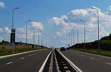
In Ukraine high-speed divided highways or motorways are called automagistrals which is a generic Russian-type term for high-speed road. Currently automagistrals are not designated into a separate network, instead only segments of automobile roads adopted for automagistrals.
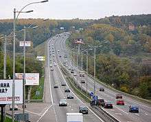
In the late 2000s there were installed first improved highspeed freeways such as the automagistral Kiev - Boryspil (Ukrainian: Автомагістраль Київ - Бориспіль) which connected the capital with its major airport and runs along M03 road and the other one Kharkiv - Dnipro which connected to major cities and runs along M18 road. The Kiev-Boryspil freeway stretches for 18 km (11 mi) and has an ability to allow the traffic volume of 40,000 vehicles on daily basis (24 hrs). Important supplemental feature of the automagistral is an electronic informational system that allows to inform the traveling drivers of any updates on the route. That experimental project was installed in 2007 and cost 40 million hryvnia.
Road characteristics categories
Aside of classification the roads in Ukraine are categorized by the road's ability to handle a certain degree of traffic. There are five categories with roads of I category split in a and b subcategories. Also all roads of I category are considered automagistrals, however not all of them could be considered as real motorways. Around 2010 there were two major automagistrals: Kiev - Boryspil and Kharkiv - Dnipro. They are categorized as the top roads of category Ia.
| Categories | IA | IB | II | III | IV | V |
|---|---|---|---|---|---|---|
| Average traffic intensity (daily) | >7,000 | >7,000 | >3,000-7,000 | >1,000-3,000 | >200-1,000 | <200 |
| Maximum traffic intensity (daily) | >14,000 | >14,000 | >6,000-14,000 | >2,000-6,000 | >400-2,000 | <400 |
| Estimated traffic speed, km/h | 150 | 120 | 120 | 100 | 80 | 60 |
| Number of lanes (in both directions) | 4-6 | 4-6 | 2 | 2 | 2 | 1(total) |
| Width of lanes, m | 3,75 | 3,75 | 3,75 | 3,75 | 3,5 | 4,5 |
| Width of median, m | 6 | 5 | - | - | - | - |
| Width of an edge reinforced lane on median, m | 1 | 1 | - | - | - | - |
| Width of an edge reinforced lane on roadside, m | 0,75 | 0,75 | 0,75 | 0,5 | - | - |
| Total road width, m | 28,5 | 27,5 | 15 | 12 | 10 | 6 |
| Radius of a curvature on a turn, m | 1,200 | 800 | 800 | 600 | 300 | 150 |
| Maximum lengthwise gradient, per mil | 30 | 40 | 40 | 50 | 60 | 70 |
List of International E-road network in Ukraine
The European routes are part of the International E-road network, routes of which run not only throughout the European continent covering such remote areas as the British Isles, but also parts of the Asian continent regions such as Middle Asia, Caucasus mountains, and Asia Minor. The European routes in Ukraine mostly travel on the Ukrainian International routes network, known as M-network.
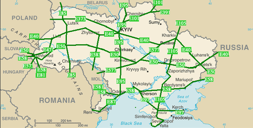
In the list below with a green background are identified the main routes. Those are either ones that end with zero (0) or five (5). Note that odd numbers have north-south directions and even numbers - east-west. With the red background are the obsolete routes.
| Highway | Local routes | Length in Ukraine | Notes |
|---|---|---|---|
| P65 | 37 km | The shortest | |
| 1334 km | The longest | ||
| P54 - |
41 km | ||
| Changed to |
|||
| 692 km | ferry service in Odessa | ||
| 423.6 km | Kerch Strait ferry | ||
| 777 km | |||
| Auxiliary routes | |||
| 62.5 km | |||
| 486.5 km | |||
| Kiev - Hlukhiv | |||
| Hlukhiv (same as |
160 km | ||
| 221 km | |||
| 26 km | |||
| Changed to |
|||
| 58.7 km | |||
| 260 km | |||
| 507 km | |||
Notes:
- Route
Transportation corridors
The European route network creates several important transport corridors known as Pan-European corridors and also including such as Gdańsk-Odessa, Eurasian, Europe-Asia, ChES, and others. There exist a proposition to create a beltway around the Black Sea, traveling through the Crimean peninsula.
Among the Pan-European corridors system, Ukraine houses such corridors as III (Brussels - Dresden - Krakow - Kiev), V (Venice - Budapest - Lviv - Kiev), VII (The Danube river), and IX (Helsinki - Saint-Petersburg - Gomel - Kiev - Chisinau - Bucharest - Thrace).
Border checkpoints
| Country | Highway | Nearest settlement | Region |
|---|---|---|---|
| Bachivsk, Hlukhiv Raion | Sumy | ||
| Novoazovsk | |||
| Dolzhansky | |||
| Shcherbakivka | |||
| Izvaryne, Krasnodon | Luhansk | ||
| Shehyni, Mostyska Raion | Lviv | ||
| Krakivets, Yavoriv Raion | |||
| Rava-Ruska, Zhovkva Raion | |||
| Ustyluh, Volodymyr-Volynskyi Raion | Volyn | ||
| Yahodyn | |||
| Kosyny, Chop | Zakarpattia | ||
| Uzhhorod | |||
| Maly Berezny, Velykyy Bereznyi Raion | |||
| Kuchurhan, Rozdilnianskyi Raion | |||
| Mamalyha, Novoselytsia Raion | Chernivtsi | ||
| Platonove, Krasni Okny Raion | |||
| Mohyliv-Podilsky | Vinnytsia | ||
| Velyka Kopanya | |||
| Reni | Odessa | ||
| Terebleche | |||
| Domanove | |||
| Novi Yarylovychi, Ripky Raion | Chernihiv |
Important projects
The project was confirmed in 2007 by the Cabinet of Ministers of Ukraine as part of the 2007-2011 program of roads development in Ukraine. The route will start on the border with Hungary at village Kosyny (Zakarpattya Oblast) and will connect to ![]()
The project is estimated at around $5 billion and will include 875 artificial constructions such as bridges and road interchanges (30). It is planned to start the route from ![]()
- Avtomagistal Yahodyn - Khmelnytsky 350 kilometres (220 mi).[14]
- Avtomagistal Vinnytsia - Dnipro 530 kilometres (330 mi).[15]
- New Kiev Beltway 206 kilometres (128 mi).[17]
Roads of local importance
The local importance roads have three classes as well, but only two indexes T, O. The Raion network of roads does not have a system implemented. The indexes for the local roads are also supplemented by an oblast index where they are located.
| Index | Oblast/City | Road length, km | Index | Oblast/City | Road length, km | Index | Oblast/City | Road length, km |
|---|---|---|---|---|---|---|---|---|
| 01 | Crimea | 6,605 | 10 | Kiev Oblast | 8,490 | 20 | Ternopil Oblast | 5,063 |
| 02 | Vinnytsia Oblast | 9,519 | 12 | Kirovohrad Oblast | 6,545 | 21 | Kharkiv Oblast | 9,551 |
| 03 | Volyn Oblast | 6,199 | 13 | Luhansk Oblast | 5,810 | 22 | Kherson Oblast | 4,950 |
| 04 | Dnipropetrovsk Oblast | 9,182 | 14 | Lviv Oblast | 8,334 | 23 | Khmelnytsky Oblast | 7,136 |
| 05 | Donetsk Oblast | 8,052 | 15 | Mykolaiv Oblast | 4,831 | 24 | Cherkasy Oblast | 6,118 |
| 06 | Zhytomyr Oblast | 8,513 | 16 | Odessa Oblast | 8,232 | 25 | Chernihiv Oblast | 7,680 |
| 07 | Zakarpattia Oblast | 3,330 | 17 | Poltava Oblast | 8,836 | 26 | Chernivtsi Oblast | 2,869 |
| 08 | Zaporizhia Oblast | 6,974 | 18 | Rivne Oblast | 5,056 | 27 | Sevastopol city | |
| 09 | Ivano-Frankivsk Oblast | 4,160 | 19 | Sumy Oblast | 7,281 | |||
Note that the list is arranged in the order of Cyrillic(for some unexplained reasons Chernihiv oblast goes in front of Chernivtsi oblast). For example, the territorial highway 22 in Rivne Oblast would be identified as T-18-22 where 18 is the index for the Rivne Oblast. The T-network (Territorial) as the rest of the roads networks of local importance differs per oblast, but the road numbering itself consists of two digits. The Oblast network (O-network), on the other hand, has the same concept of T-network, but the road numbering contains four digits and the code does not have the hyphen as in T-networks. For example, a highway in Kharkiv Oblast would have code O-21xxxx.
Special routes in Ukraine

There are two main technical terms for special routes: pidyizd (ukr. під'їзд) and obyizd (ukr. об'їзд).
- Pidyizd route is usually an access route that splits from the main route towards an important geographic point such as city, airport, park etc. On the adjacent picture it can be compared to the spur route.
- Obyizd route is a type of ring road which is not necessarily complete. On the adjacent picture it can be compared to the bypass route, business route, truck route.
Historical routes
- Murava Route
- Bila Tserkva road
- Izyum Route (branch of Murava route)
- Silk Road
- Berlad road
- From the Varangians to the Greeks
- Chumak route
- Black route
- Romodanovsky route
- Kuchma route (branch of Black route)
- Kraków road
- Kolky route
- Kiev route
- Kalmius route (branch of Murava route)
- Zaloha route
Populated area roadways
Types of roadways
- Vulytsia/street, a most common and generic type of a roadway within a populated area with the English counterpart becoming more widely used
- Shose, a broad road built for high-speed traffic for big distances with limited number of points through which drivers can access it;[18] generally accessible road, especially main road that connects cities or settlements[19]
- Prospekt, a term for a broad, long, and straight road in big cities
- Bulvar, a scenic broad road, such as boulevard
- Naberezhna, a roadway along shore or bank of body of water (i.e. sea, river, or lake)
- Obyizdna/kiltseva, a roadway around city
- Provulok, a back street, small roadway such as side street
See also
- State Highways (Ukraine), list of state (national) highways
References
- 1 2 Reilly, J. Is this the worst road in Europe? Try this terrifying video from the potholed 'motorways' of Ukraine where drivers hit speeds of 100mph. Daily Mail. 18 February 2013
- ↑ Sylvester, P. Driving in Ukraine: Beware of Poor Road Safety. World Nomads. 26 Jun 2015
- ↑ Ukravtodor Regulations (in Ukrainian)
- ↑ Ministry of Transportation and Communications (in Ukrainian)
- ↑ ADU official website (in Ukrainian)
- ↑ World Bank Paves the Way for Safer Roads in Ukraine. The World Bank. November 3, 2015
- ↑ Dan Peleschuk (16 June 2016). "Ukraine's Broken Road to Europe". Foreign Policy. Retrieved 17 June 2016.
- 1 2 Road works booming: Ukraine plans to change its road map within 3 years, UNIAN (16 November 2017)
- ↑ Avtomagistral Kosyni - Kiev (in Russian)
- ↑ List of road projects
- ↑ Avtomagistral Vinnytsia - Kiev
- ↑ Avtomagistral Dnipro - Luhansk (in Russian)
- ↑ Avtomagistral Odessa - Dnipro (in Russian)
- ↑ Avtomagistral Yahodyn - Khmelnytsky (in Russian)
- ↑ Avtomagistral Vinnytsia - Dnipro (in Russian)
- ↑ Autobahn Odessa - Reni (in Russian)
- ↑ New Kiev Beltway
- ↑ Definition of shose
- ↑ Another definition of shose
Sources
- International Highways in Ukraine (russian, ukrainian, english languages)
- List of European routes at the Wayback Machine (archived January 9, 2008)
- Convention of road markings and signals
- Official text of the European agreement on International Highway System (E-Network)
- Declaration of the Cabinets Ministers of Ukrainian SSR of joining the European agreement on E-Network
- Law of Ukraine on automobile roads (highways), Law of Ukraine on road movement, Law of Ukraine on transport, Regulations for the international highways of the Commonwealth of Independent States
- Declaration of Cabinet of Minister of Ukraine on the tollway Lviv-Krakovets, Law of Ukraine on the tollway Kiev-Odessa
- Traffic signs in Ukraine
- List of state automobile roads for general use. Cabinet of Ukraine. January 1, 2013
| E-roads in Ukraine | ||
|---|---|---|
| International | ||
| National | ||
| Regional |
| |
| ||