Freedom (community), Outagamie County, Wisconsin
| Freedom, Wisconsin | |
|---|---|
| Unincorporated community | |
 Freedom, Wisconsin  Freedom, Wisconsin | |
| Coordinates: 44°23′11″N 88°17′19″W / 44.38639°N 88.28861°WCoordinates: 44°23′11″N 88°17′19″W / 44.38639°N 88.28861°W | |
| Country | United States |
| State | Wisconsin |
| County | Outagamie |
| Elevation | 751 ft (229 m) |
| Time zone | UTC-6 (Central (CST)) |
| • Summer (DST) | UTC-5 (CDT) |
| ZIP code | 54131 |
| Area code(s) | 920 |
| GNIS feature ID | 1565290[1] |
Freedom is an unincorporated community located in the town of Freedom, Outagamie County, Wisconsin, United States. Freedom is located along Wisconsin Highway 55 7.5 miles (12.1 km) north of Kaukauna. Freedom has a post office, located in Kaukauna, which uses ZIP code 54131.[2]
Before the establishment of the Town of Freedom on June 5, 1853, evidence suggests that this community was named Sagole or Sagola, a Native American word meaning "good morning". Further, this name's use fell out of favor after the name of the surrounding town was established, and the community began using the name Freedom as well.[3][4] Freedom is home to a very successful high school as well. They have won many state championships.
Images
 St Nicholas Catholic Church
 Welcome sign
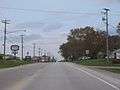 Looking north at Freedom from Highway 55
 Freedom High School
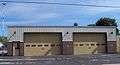 Freedom town hall and fire station
References
- ↑ U.S. Geological Survey Geographic Names Information System: Freedom (community), Outagamie County, Wisconsin
- ↑ "Free ZIP Code Lookup with area code, county, geocode, MSA/PMSA, population". www.zipinfo.com. Retrieved 2016-09-29.
- ↑ Outagamie County State Centennial Committee (1949). "Land of the Fox, Saga of Outagamie County" (PDF). Retrieved 2016-09-28.
- ↑ "History of Freedom, Wisconsin". history.rays-place.com. Retrieved 2016-09-29.
Municipalities and communities of Outagamie County, Wisconsin, United States | ||
|---|---|---|
| Cities | 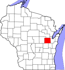 | |
| Villages | ||
| Towns | ||
| CDP | ||
| Unincorporated communities | ||
| Indian reservation | ||
| Ghost towns/neighborhoods | ||
| Footnotes | ‡This populated place also has portions in an adjacent county or counties | |
This article is issued from
Wikipedia.
The text is licensed under Creative Commons - Attribution - Sharealike.
Additional terms may apply for the media files.