Murphy Corner, Wisconsin
| Murphy Corner, Wisconsin | |
|---|---|
| Unincorporated community | |
| Nickname(s): Skunk Hill | |
 Murphy Corner, Wisconsin  Murphy Corner, Wisconsin | |
| Coordinates: 44°23′11″N 88°20′05″W / 44.38639°N 88.33472°WCoordinates: 44°23′11″N 88°20′05″W / 44.38639°N 88.33472°W | |
| Country | United States |
| State | Wisconsin |
| County | Outagamie |
| Elevation[1] | 811 ft (247 m) |
| Time zone | UTC-6 (Central (CST)) |
| • Summer (DST) | UTC-5 (CDT) |
| ZIP Codes | 54130, 54913 |
Murphy Corner is an unincorporated community in the town of Freedom, Outagamie County, Wisconsin, United States.
Geography
Murphy Corner is located at 44°23′11″N 88°20′05″W / 44.38639°N 88.33472°W(44.383333, -88.333333).[2] Its elevation is 811 feet (247m).
Transportation
| Highway C Northern Terminus is WIS 55/WIS 54 its Southern terminus is Highway E and its Western Terminus is WIS 76. | |
| Highway S Western Terminus is WIS 54 and its Eastern Terminus is S County Line Rd. |
References
- ↑ "Murphy Corner". Geographic Names Information System. United States Geological Survey.
- ↑ "US Gazetteer files: 2010, 2000, and 1990". United States Census Bureau. 2011-02-12. Retrieved 2011-04-23.
Municipalities and communities of Outagamie County, Wisconsin, United States | ||
|---|---|---|
| Cities | 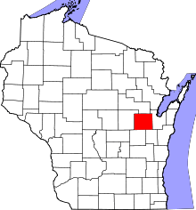 | |
| Villages | ||
| Towns | ||
| CDP | ||
| Unincorporated communities | ||
| Indian reservation | ||
| Ghost towns/neighborhoods | ||
| Footnotes | ‡This populated place also has portions in an adjacent county or counties | |
This article is issued from
Wikipedia.
The text is licensed under Creative Commons - Attribution - Sharealike.
Additional terms may apply for the media files.