Hamarøy
| Hamarøy kommune Hábmera suohkan | |||
|---|---|---|---|
| Municipality | |||
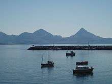
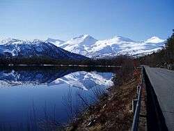 View near Tømmernes in Hamarøy | |||
| |||
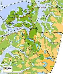
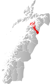 Hamarøy within Nordland | |||
| Coordinates: 68°04′33″N 15°46′56″E / 68.07583°N 15.78222°ECoordinates: 68°04′33″N 15°46′56″E / 68.07583°N 15.78222°E | |||
| Country | Norway | ||
| County | Nordland | ||
| District | Salten | ||
| Established | 1838 | ||
| Administrative centre | Oppeid | ||
| Government | |||
| • Mayor (2015) | Jan-Folke Sandnes[1] (Conservative Party) | ||
| Area | |||
| • Total | 1,033.59 km2 (399.07 sq mi) | ||
| • Land | 924.10 km2 (356.80 sq mi) | ||
| • Water | 109.49 km2 (42.27 sq mi) | ||
| Area rank | #104 in Norway | ||
| Population (2017) | |||
| • Total | 1,810 | ||
| • Rank | #338 in Norway | ||
| • Density | 2/km2 (5/sq mi) | ||
| • Change (10 years) | 2.2% | ||
| Demonym(s) |
Hamarøying Hamarøyværing[2] | ||
| Time zone | UTC+01:00 (CET) | ||
| • Summer (DST) | UTC+02:00 (CEST) | ||
| ISO 3166 code | NO-1849 | ||
| Official language form | Neutral | ||
| Website |
hamaroy | ||
Hamarøy (Norwegian) or Hábmer (Lule Sami)[3] is a municipality in Nordland county, Norway. It is part of the traditional district of Salten. The administrative centre of the municipality is the village of Oppeid. Other villages include Innhavet, Karlsøy, Presteid, Skutvika, Tømmerneset, Tranøy, and Ulvsvåg.
The 1,034-square-kilometre (399 sq mi) municipality is the 104th largest by area out of the 422 municipalities in Norway. Hamarøy is the 338th most populous municipality in Norway with a population of 1,810. The municipality's population density is 2 inhabitants per square kilometre (5.2/sq mi) and its population has increased by 2.2% over the last decade.[4]
General information
The municipality of Hamarøy was established on 1 January 1838 (see formannskapsdistrikt). On 1 January 1964, part of Hamarøy located south of the Sagfjorden (population: 77) was transferred to neighboring Steigen. On the same date, the Tysnes and Molvik farms (population: 33) was transferred from Hamarøy to Tysfjord.[5]
In 2017, it was decided that the neighboring municipality of Tysfjord would be divided along the fjord with the eastern half being merged with the neighboring municipalities of Narvik and Ballangen to form a new, larger municipality of Narvik effective 1 January 2020. The remaining western half will be merged with the municipality of Hamarøy on the same date.[6][7]
Name
The municipality is named after the former island (now peninsula) Hamarøya (Old Norse: Hamarøy), since the first church (Hamarøy Church) was built there. The first element is the genitive case of Hǫm, the former uncompounded name of the island. The last element is øy which means "island". The former name of the island is probably identical with the word hǫm which means "thigh/leg (of an animal)" because the island (or a part of it) was shaped in the form of an animal's leg. Historically, the municipality name was spelled Hammerø.[8]
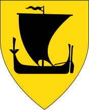
Coat-of-arms
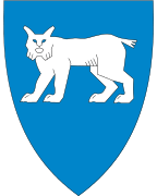
The coat-of-arms is from modern times; they were granted on 19 February 1982. The arms show a white lynx on a blue background. Lynx are common in the area it was chosen for the arms as a symbol for the rich wildlife in the forests of the municipality.[9]
Churches
The Church of Norway has two parishes (sokn) within the municipality of Hamarøy. It is part of the Ofoten prosti (deanery) in the Diocese of Sør-Hålogaland.
| Parish (Sokn) | Church Name | Location of the Church | Year Built |
|---|---|---|---|
| Hamarøy | Hamarøy Church | Presteid | 1974 |
| Sagfjord | Sagfjord Church | Karlsøy | 1770 |
| Tømmernes Church | Tømmerneset | 1952 |
Geography

The municipality of Hamarøy borders the municipality of Tysfjord to the north, Steigen to the west, Sørfold to the south, the Vestfjorden to the northwest, and the country of Sweden to the southeast. The large island of Finnøya is located between the Sagfjorden and the Kaldvågfjorden.
Lakes in the municipality include Fjerdvatnet, Forsanvatnet, Forsvatnet, Kaldvågvatnet, Kilvatnet, Livsejávrre, Makkvatnet, Reinoksvatnet, Rekvatnet, Rotvatnet, Sandnesvatnet, Skilvatnet, Šluŋkkajávri, and Strindvatnet.
Nature
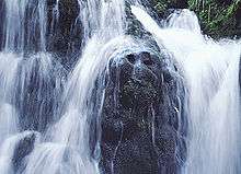
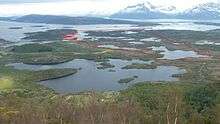
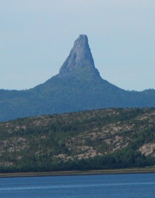
Hamarøy is dominated by small fjords, pine, birch, and aspen woodland and forest, and coastal mountains. There are several nature reserves, such as Trollpollen nature reserve dominated by pine and birch[10] located a few kilometers north of Innhavet, Lilandsvatnet wetland area,[11] Steinslandsosen estuary,[12] and Kvannskogen with old aspen trees with rich lichen flora.[13] The mountain Hamarøyskaftet has long been regarded as nature's own phallic symbol (See picture 1 and picture 2).
Climate
The warmest temperature ever recorded in Nordland county was 33.1 °C (91.6 °F) on 3 July 1972 on the island of Finnøya in Hamarøy. However, in June 2011 this record was surpassed by the municipality of Saltdal with a temperature of 33.8 °C (92.8 °F).
Government
All municipalities in Norway, including Hamarøy, are responsible for primary education (through 10th grade), outpatient health services, senior citizen services, unemployment and other social services, zoning, economic development, and municipal roads. The municipality is governed by a municipal council of elected representatives, which in turn elect a mayor.
Municipal council
The municipal council (Kommunestyre) of Hamarøy is made up of 17 representatives that are elected to four year terms. Currently, the party breakdown is as follows:[14]
| Party Name | Name in Norwegian | Number of representatives | |
|---|---|---|---|
| Labour Party | Arbeiderpartiet | 4 | |
| Progress Party | Fremskrittspartiet | 1 | |
| Conservative Party | Høyre | 4 | |
| Centre Party | Senterpartiet | 3 | |
| Socialist Left Party | Sosialistisk Venstreparti | 1 | |
| Liberal Party | Venstre | 4 | |
| Total number of members: | 17 | ||
Transportation
While Hamarøy has a low population density, it sees some traffic during the summer months as the main road connection to Svolvær and the Lofoten islands runs through Hamarøy and its administrative centre, Oppeid. The ferry ride to Skrova and Svolvær is approximately 2 hours and departs from Skutvika (approximately 15 minutes from Oppeid) at regular intervals. In 2008, the ferry schedule was considerably reduced due to the new Lofoten Mainland Connection road. The European route E06 highway runs north and south through the municipality on its way to Narvik. Bus service by Stoklands Bilruter is available between certain villages in Hamarøy.
Economy
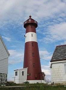
The municipal administration and other public services are located in Oppeid. There is a hotel in the municipality, as well as the scenic Tranøy Lighthouse which can be rented.[15]
Skutvik is a small residential and marina area concentrated around the ferry dock. In the high season the number of cars and motor homes in line for the ferry can be significant. There are a few sights to see in Skutvik, as well as a small bar/cafe and a Statoil gas station.
Knut Hamsun

The writer Knut Hamsun, winner of the 1920 Nobel Prize in Literature, grew up in Hamarøy. The Knut Hamsun Centre, a museum and educational center dedicated to Knut Hamsun's life and work, finished building in 2009 and opened for the public in June 2010. Knut Hamsun's childhood home is also open for visitors in summer. The Hamsun literature festival was founded in 1982 and takes place in Hamarøy during the first week of August every second year.
References
- ↑ "Han blir ny ordfører i Hamarøy". Fremover (in Norwegian). 2015-10-14. Retrieved 2015-10-14.
- ↑ "Navn på steder og personer: Innbyggjarnamn" (in Norwegian). Språkrådet. Retrieved 2015-12-01.
- ↑ "Stadnamn og rettskriving" (in Norwegian). Kartverket. Retrieved 2018-07-13.
- ↑ Statistisk sentralbyrå (2017). "Table: 06913: Population 1 January and population changes during the calendar year (M)" (in Norwegian). Retrieved 2017-09-09.
- ↑ Jukvam, Dag (1999). "Historisk oversikt over endringer i kommune- og fylkesinndelingen" (PDF) (in Norwegian). Statistisk sentralbyrå.
- ↑ Karlsen, Tone Anita (2017-08-22). "Ny Narvik tar form". Harstad Tidende (in Norwegian). Retrieved 2017-09-10.
- ↑ "Intensjonsavtale Hamarøy og Tysfjord" (in Norwegian). Tysfjord kommune. 2016-12-13. Retrieved 2017-09-10.
- ↑ Rygh, Oluf (1905). Norske gaardnavne: Nordlands amt (in Norwegian) (16 ed.). Kristiania, Norge: W. C. Fabritius & sønners bogtrikkeri. p. 263.
- ↑ Norske Kommunevåpen (1990). "Nye kommunevåbener i Norden". Retrieved 2008-11-23.
- ↑ "Trollpollen naturreservat" (in Norwegian). Archived from the original on 2007-09-26. Retrieved 2008-11-23.
- ↑ "Lilandsvatnet naturreservat" (in Norwegian). Archived from the original on 2007-09-26. Retrieved 2008-11-23.
- ↑ "Steinslandsosen naturreservat" (in Norwegian). Archived from the original on 2007-09-26. Retrieved 2008-11-23.
- ↑ "Kvannskogen naturreservat" (in Norwegian). Archived from the original on 2012-04-16. Retrieved 2008-11-23.
- ↑ "Table: 04813: Members of the local councils, by party/electoral list at the Municipal Council election (M)" (in Norwegian). Statistics Norway. 2015.
- ↑ "Tranøy fyr". Archived from the original on 2009-02-06. Retrieved 2008-11-23.
External links
- Municipal fact sheet from Statistics Norway (in Norwegian)
| Wikimedia Commons has media related to Hamarøy. |

- The Knut Hamsun Centre
- The Knut Hamsun Centre's architecture
| |||||||||||||||||
| |||||||||||||||||