Lingle, Wyoming
| Lingle, Wyoming | |
|---|---|
| Town | |
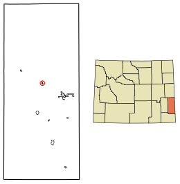 Location of Lingle in Goshen County, Wyoming. | |
 Lingle, Wyoming Location in the `United States | |
| Coordinates: 42°8′15″N 104°20′47″W / 42.13750°N 104.34639°WCoordinates: 42°8′15″N 104°20′47″W / 42.13750°N 104.34639°W | |
| Country |
|
| State |
|
| County |
|
| Area[1] | |
| • Total | 0.31 sq mi (0.80 km2) |
| • Land | 0.31 sq mi (0.80 km2) |
| • Water | 0 sq mi (0 km2) |
| Elevation | 4,173 ft (1,272 m) |
| Population (2010)[2] | |
| • Total | 468 |
| • Estimate (2016)[3] | 459 |
| • Density | 1,509.7/sq mi (582.9/km2) |
| Time zone | UTC-7 (Mountain (MST)) |
| • Summer (DST) | UTC-6 (MDT) |
| ZIP code | 82223 |
| Area code(s) | 307 |
| FIPS code | 56-46790[4] |
| GNIS feature ID | 1590714[5] |
Lingle is a town in Goshen County, Wyoming, United States. The population was 468 at the 2010 census.
Former Wyoming Supreme Court Justice Richard V. Thomas was reared in Lingle.
Geography
Lingle is located at 42°8′15″N 104°20′47″W / 42.13750°N 104.34639°W (42.137494, -104.346500).[6]
According to the United States Census Bureau, the town has a total area of 0.31 square miles (0.80 km2), all of it land.[1]
Demographics
| Historical population | |||
|---|---|---|---|
| Census | Pop. | %± | |
| 1920 | 363 | — | |
| 1930 | 415 | 14.3% | |
| 1940 | 428 | 3.1% | |
| 1950 | 403 | −5.8% | |
| 1960 | 437 | 8.4% | |
| 1970 | 446 | 2.1% | |
| 1980 | 475 | 6.5% | |
| 1990 | 473 | −0.4% | |
| 2000 | 510 | 7.8% | |
| 2010 | 468 | −8.2% | |
| Est. 2016 | 459 | [3] | −1.9% |
| U.S. Decennial Census[7] | |||
2010 census
As of the census[2] of 2010, there were 468 people, 204 households, and 138 families residing in the town. The population density was 1,509.7 inhabitants per square mile (582.9/km2). There were 217 housing units at an average density of 700.0 per square mile (270.3/km2). The racial makeup of the town was 97.4% White, 0.2% African American, 0.4% Native American, 1.3% from other races, and 0.6% from two or more races. Hispanic or Latino of any race were 3.0% of the population.
There were 204 households of which 30.4% had children under the age of 18 living with them, 55.4% were married couples living together, 10.8% had a female householder with no husband present, 1.5% had a male householder with no wife present, and 32.4% were non-families. 30.4% of all households were made up of individuals and 13.7% had someone living alone who was 65 years of age or older. The average household size was 2.29 and the average family size was 2.82.
The median age in the town was 43.9 years. 24.1% of residents were under the age of 18; 6.4% were between the ages of 18 and 24; 20.3% were from 25 to 44; 29.9% were from 45 to 64; and 19.2% were 65 years of age or older. The gender makeup of the town was 43.6% male and 56.4% female.
2000 census
As of the census[4] of 2000, there were 510 people, 210 households, and 140 families residing in the town. The population density was 1,653.6 people per square mile (635.2/km²). There were 234 housing units at an average density of 758.7 per square mile (291.4/km²). The racial makeup of the town was 96.67% White, 0.20% Pacific Islander, 1.57% from other races, and 1.57% from two or more races. Hispanic or Latino of any race were 4.12% of the population.
There were 210 households out of which 28.1% had children under the age of 18 living with them, 57.6% were married couples living together, 6.2% had a female householder with no husband present, and 32.9% were non-families. 28.6% of all households were made up of individuals and 11.4% had someone living alone who was 65 years of age or older. The average household size was 2.43 and the average family size was 2.98.
In the town, the population was spread out with 26.7% under the age of 18, 6.1% from 18 to 24, 26.1% from 25 to 44, 24.3% from 45 to 64, and 16.9% who were 65 years of age or older. The median age was 40 years. For every 100 females, there were 93.9 males. For every 100 females age 18 and over, there were 98.9 males.
The median income for a household in the town was $33,235, and the median income for a family was $38,036. Males had a median income of $30,313 versus $22,500 for females. The per capita income for the town was $16,559. About 4.0% of families and 9.4% of the population were below the poverty line, including 4.7% of those under age 18 and 13.2% of those age 65 or over.
Education
Public education in the town of Lingle is provided by Goshen County School District #1.
Highways
References
- 1 2 "US Gazetteer files 2010". United States Census Bureau. Archived from the original on 2012-07-14. Retrieved 2012-12-14.
- 1 2 "American FactFinder". United States Census Bureau. Retrieved 2012-12-14.
- 1 2 "Population and Housing Unit Estimates". Retrieved June 9, 2017.
- 1 2 "American FactFinder". United States Census Bureau. Retrieved 2008-01-31.
- ↑ "US Board on Geographic Names". United States Geological Survey. 2007-10-25. Retrieved 2008-01-31.
- ↑ "US Gazetteer files: 2010, 2000, and 1990". United States Census Bureau. 2011-02-12. Retrieved 2011-04-23.
- ↑ "Census of Population and Housing". Census.gov. Retrieved June 4, 2015.
External links
Municipalities and communities of Goshen County, Wyoming, United States | ||
|---|---|---|
| City | 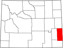 | |
| Towns | ||
| CDPs | ||
| Unincorporated community | ||