Georgetown, Beaver County, Pennsylvania
| Georgetown, Pennsylvania | |
|---|---|
| Borough | |
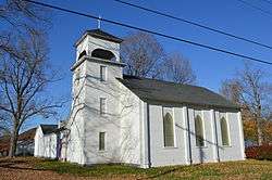 St. Luke's Anglican Church, built 1833 | |
 Location in Beaver County and the state of Pennsylvania. | |
| Coordinates: 40°38′28″N 80°30′00″W / 40.64111°N 80.50000°WCoordinates: 40°38′28″N 80°30′00″W / 40.64111°N 80.50000°W | |
| Country | United States |
| State | Pennsylvania |
| County | Beaver |
| Settled | 1793 |
| Incorporated | 1850 |
| Government | |
| • Type | Borough Council |
| Area[1] | |
| • Total | 0.25 sq mi (0.65 km2) |
| • Land | 0.17 sq mi (0.45 km2) |
| • Water | 0.08 sq mi (0.20 km2) |
| Elevation | 741 ft (226 m) |
| Population (2010) | |
| • Total | 174 |
| • Estimate (2016)[2] | 171 |
| • Density | 977.14/sq mi (377.40/km2) |
| Time zone | UTC-5 (Eastern (EST)) |
| • Summer (DST) | UTC-4 (EDT) |
| Zip code | 15043 |
| Area code(s) | 724 |
| FIPS code | 42-28824 |
| GNIS feature ID | 1214876 |
Georgetown is a borough in Beaver County, Pennsylvania, United States, along the Ohio River. The population was 174 at the 2010 census. It was founded in 1793 by Benoni Dawson. Little Blue Run Lake, the U.S.'s largest coal slurry waste impound is located next to the town.
Geography

Georgetown is located at 40°38′28″N 80°30′0″W / 40.64111°N 80.50000°W (40.641172, -80.500037).[3]
According to the United States Census Bureau, the borough has a total area of 0.3 square miles (0.78 km2), of which, 0.2 square miles (0.52 km2) of it is land and 0.1 square miles (0.26 km2) of it (33.33%) is water.
Surrounding and adjacent neighborhoods
Georgetown is surrounded by Greene Township to the south, east and west. Across the Ohio River to the north, the borough runs adjacent with Glasgow and Ohioville.
Demographics
| Historical population | |||
|---|---|---|---|
| Census | Pop. | %± | |
| 1860 | 295 | — | |
| 1870 | 297 | 0.7% | |
| 1880 | 288 | −3.0% | |
| 1890 | 274 | −4.9% | |
| 1900 | 271 | −1.1% | |
| 1910 | 269 | −0.7% | |
| 1920 | 251 | −6.7% | |
| 1930 | 260 | 3.6% | |
| 1940 | 253 | −2.7% | |
| 1950 | 246 | −2.8% | |
| 1960 | 246 | 0.0% | |
| 1970 | 234 | −4.9% | |
| 1980 | 231 | −1.3% | |
| 1990 | 194 | −16.0% | |
| 2000 | 182 | −6.2% | |
| 2010 | 174 | −4.4% | |
| Est. 2016 | 171 | [2] | −1.7% |
| Sources:[4][5][6] | |||
As of the census[5] of 2000, there were 182 people, 67 households, and 52 families residing in the borough. The population density was 1,010.6 people per square mile (390.4/km²). There were 70 housing units at an average density of 388.7 per square mile (150.2/km²). The racial makeup of the borough was 100.00% White.
There were 67 households, out of which 34.3% had children under the age of 18 living with them, 70.1% were married couples living together, 3.0% had a female householder with no husband present, and 20.9% were non-families. 16.4% of all households were made up of individuals, and 11.9% had someone living alone who was 65 years of age or older. The average household size was 2.72 and the average family size was 3.11.
In the borough the population was spread out, with 22.0% under the age of 18, 7.7% from 18 to 24, 28.0% from 25 to 44, 25.3% from 45 to 64, and 17.0% who were 65 years of age or older. The median age was 40 years. For every 100 females, there were 122.0 males. For every 100 females age 18 and over, there were 105.8 males.
The median income for a household in the borough was $57,500, and the median income for a family was $59,167. Males had a median income of $38,750 versus $31,528 for females. The per capita income for the borough was $19,838. About 4.0% of families and 3.3% of the population were below the poverty line, including 3.7% of those under the age of eighteen and none of those sixty five or over.
See also
References
- ↑ "2016 U.S. Gazetteer Files". United States Census Bureau. Retrieved Jul 4, 2017.
- 1 2 "Population and Housing Unit Estimates". Retrieved June 9, 2017.
- ↑ "US Gazetteer files: 2010, 2000, and 1990". United States Census Bureau. 2011-02-12. Retrieved 2011-04-23.
- ↑ "Census of Population and Housing". U.S. Census Bureau. Archived from the original on 12 May 2015. Retrieved 11 December 2013.
- 1 2 "American FactFinder". United States Census Bureau. Archived from the original on 2013-09-11. Retrieved 2008-01-31.
- ↑ "Incorporated Places and Minor Civil Divisions Datasets: Subcounty Resident Population Estimates: April 1, 2010 to July 1, 2012". Population Estimates. U.S. Census Bureau. Archived from the original on 17 June 2013. Retrieved 11 December 2013.
| Counties |  Map of the Pittsburgh Tri-State with green counties in the metropolitan area and yellow counties in the combined area. | |
|---|---|---|
| Major cities | ||
| Cities and towns 15k-50k (in 2010) | ||
| Airports | ||
| Topics | ||
| ||
Municipalities and communities of Beaver County, Pennsylvania, United States | ||
|---|---|---|
| Cities | 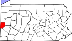 | |
| Boroughs |
| |
| Townships | ||
| Unincorporated communities | ||
| Footnotes | ‡This populated place also has portions in an adjacent county or counties | |