Koppel, Pennsylvania
| Koppel, Pennsylvania | |
|---|---|
| Borough | |
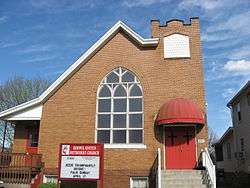 Koppel United Methodist Church | |
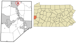 Location in Beaver County and the U.S. state of Pennsylvania. | |
| Coordinates: 40°50′00″N 80°19′25″W / 40.83333°N 80.32361°WCoordinates: 40°50′00″N 80°19′25″W / 40.83333°N 80.32361°W | |
| Country | United States |
| State | Pennsylvania |
| County | Beaver |
| Incorporated | 1910 |
| Government | |
| • Type | Borough Council |
| Area[1] | |
| • Total | 0.57 sq mi (1.48 km2) |
| • Land | 0.54 sq mi (1.39 km2) |
| • Water | 0.04 sq mi (0.09 km2) |
| Elevation | 906 ft (276 m) |
| Population (2010) | |
| • Total | 762 |
| • Estimate (2016)[2] | 736 |
| • Density | 1,370.58/sq mi (528.84/km2) |
| Time zone | UTC-5 (Eastern (EST)) |
| • Summer (DST) | UTC-4 (EDT) |
| Zip code | 16136 |
| Area code(s) | 724 |
| FIPS code | 42-40400 |
Koppel is a borough in Beaver County, Pennsylvania, United States, and part of the Pittsburgh metropolitan area since 1950. The population was 762 at the 2010 census.[3]
History
Koppel was named after Arthur Koppel of Orenstein & Koppel which was a German manufacturing company that owned 558 acres of land in nearby Big Beaver Township by 1907. In 1912, Koppel was established as a borough. The next year, Orenstein & Koppel donated land to the new borough for school and municipal buildings. After most of the town was confiscated by the Office of Alien Property Custodian from Orenstein & Koppel in 1917, much of the property was sold to the Koppel Industrial and Equipment Company. Other manufacturing companies had a presence in Koppel—the Pressed Steel Car Co. from 1919 to 1937 and Babcock & Wilcox during the 1950s.[4]
Geography
Koppel is located in northern Beaver County at 40°50′0″N 80°19′25″W / 40.83333°N 80.32361°W (40.833402, -80.323675)[5] along the west bank of the Beaver River. Pennsylvania Route 18 (Big Beaver Boulevard) follows the western border of the borough, leading south 6 miles (10 km) to Beaver Falls and north 14 miles (23 km) to New Castle. Pennsylvania Route 351 crosses Route 18 and runs through the center of Koppel, leading northeast 3 miles (5 km) to Ellwood City and west 2.5 miles (4.0 km) to Interstate 376 at the Pennsylvania Turnpike.
According to the United States Census Bureau, Koppel has a total area of 0.58 square miles (1.5 km2), of which 0.54 square miles (1.4 km2) is land and 0.039 square miles (0.1 km2), or 6.14%, is water.[3]
Surrounding neighborhoods
Koppel has only two borders, including Big Beaver to the north, south and west, and North Sewickley Township to the east.
Demographics
| Historical population | |||
|---|---|---|---|
| Census | Pop. | %± | |
| 1920 | 762 | — | |
| 1930 | 1,057 | 38.7% | |
| 1940 | 1,064 | 0.7% | |
| 1950 | 1,137 | 6.9% | |
| 1960 | 1,389 | 22.2% | |
| 1970 | 1,312 | −5.5% | |
| 1980 | 1,146 | −12.7% | |
| 1990 | 1,024 | −10.6% | |
| 2000 | 856 | −16.4% | |
| 2010 | 762 | −11.0% | |
| Est. 2016 | 736 | [2] | −3.4% |
| Sources:[6][7][8] | |||
As of the census[7] of 2000, there were 856 people, 373 households, and 246 families residing in the borough. The population density was 1,619.0 people per square mile (623.6/km²). There were 409 housing units at an average density of 773.6 per square mile (298.0/km²). The racial makeup of the borough was 98.25% White, 0.47% African American, and 1.29% from two or more races. Hispanic or Latino of any race were 0.35% of the population.
There were 373 households, out of which 20.4% had children under the age of 18 living with them, 48.0% were married couples living together, 13.9% had a female householder with no husband present, and 33.8% were non-families. 30.3% of all households were made up of individuals, and 18.0% had someone living alone who was 65 years of age or older. The average household size was 2.29 and the average family size was 2.83.
In the borough the population was spread out, with 18.7% under the age of 18, 6.3% from 18 to 24, 27.1% from 25 to 44, 22.8% from 45 to 64, and 25.1% who were 65 years of age or older. The median age was 44 years. For every 100 females, there were 90.6 males. For every 100 females age 18 and over, there were 83.2 males.
The median income for a household in the borough was $32,059, and the median income for a family was $36,250. Males had a median income of $33,375 versus $22,292 for females. The per capita income for the borough was $17,101. About 3.9% of families and 6.8% of the population were below the poverty line, including 10.8% of those under age 18 and 7.0% of those age 65 or over.
Notable people
- Raymond "Charlie No-Face" Robinson
- Arthur Koppel
References
- ↑ "2016 U.S. Gazetteer Files". United States Census Bureau. Retrieved Aug 13, 2017.
- 1 2 "Population and Housing Unit Estimates". Retrieved June 9, 2017.
- 1 2 "Geographic Identifiers: 2010 Demographic Profile Data (G001): Koppel borough, Beaver County, Pennsylvania". U.S. Census Bureau, American Factfinder. Retrieved February 24, 2014.
- ↑ "Koppel Borough". Beaver County Historical Research & Landmarks Foundation. Retrieved 28 December 2016.
- ↑ "US Gazetteer files: 2010, 2000, and 1990". United States Census Bureau. 2011-02-12. Retrieved 2011-04-23.
- ↑ "Census of Population and Housing". U.S. Census Bureau. Archived from the original on 12 May 2015. Retrieved 11 December 2013.
- 1 2 "American FactFinder". United States Census Bureau. Archived from the original on September 11, 2013. Retrieved 2008-01-31.
- ↑ "Incorporated Places and Minor Civil Divisions Datasets: Subcounty Resident Population Estimates: April 1, 2010 to July 1, 2012". Population Estimates. U.S. Census Bureau. Archived from the original on 17 June 2013. Retrieved 11 December 2013.
| Counties |  Map of the Pittsburgh Tri-State with green counties in the metropolitan area and yellow counties in the combined area. | |
|---|---|---|
| Major cities | ||
| Cities and towns 15k-50k (in 2010) | ||
| Airports | ||
| Topics | ||
| ||
Municipalities and communities of Beaver County, Pennsylvania, United States | ||
|---|---|---|
| Cities | 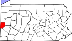 | |
| Boroughs |
| |
| Townships | ||
| Unincorporated communities | ||
| Footnotes | ‡This populated place also has portions in an adjacent county or counties | |