Shippingport, Pennsylvania
| Shippingport, Pennsylvania | |
|---|---|
| Borough | |
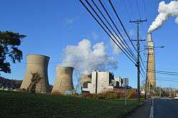 Cooling towers at the Bruce Mansfield Power Plant | |
 Location in Beaver County and the U.S. state of Pennsylvania. | |
| Coordinates: 40°37′28″N 80°25′29″W / 40.62444°N 80.42472°WCoordinates: 40°37′28″N 80°25′29″W / 40.62444°N 80.42472°W | |
| Country | United States |
| State | Pennsylvania |
| County | Beaver |
| Incorporated | 1910 |
| Government | |
| • Type | Borough Council |
| Area[1] | |
| • Total | 3.68 sq mi (9.54 km2) |
| • Land | 3.33 sq mi (8.62 km2) |
| • Water | 0.36 sq mi (0.92 km2) |
| Elevation | 741 ft (226 m) |
| Population (2010) | |
| • Total | 214 |
| • Estimate (2016)[2] | 210 |
| • Density | 63.12/sq mi (24.37/km2) |
| Time zone | UTC-5 (Eastern (EST)) |
| • Summer (DST) | UTC-4 (EDT) |
| Zip code | 15077 |
| Area code(s) | 724 |
| FIPS code | 42-70376 |
| Website |
shippingportpa |
Shippingport is a borough in Beaver County, Pennsylvania, United States, located along the Ohio River. The population was 214 at the 2010 census.[3]
Shippingport is home to the Beaver Valley Nuclear Power Station and the Bruce Mansfield Power Plant.
Nuclear energy
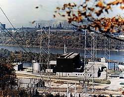
Shippingport is the site of the United States' first commercial nuclear power plant, the Shippingport Atomic Power Station, which began operation in 1957.[4] Although the original Shippingport reactor was decommissioned in 1982,[5] the Beaver Valley Nuclear Power Station Units 1 and 2 from the same site have been in operation since 1976 and 1987, respectively.
Geography
Shippingport is located in west-central Beaver County at 40°37′25″N 80°25′29″W / 40.62361°N 80.42472°W (40.623594, -80.424691),[6] on the south side of the Ohio River. It is bordered to the southwest by Greene Township and to the southeast by Raccoon Township. To the north, across the Ohio River, are the boroughs of Industry (north) and Midland (northwest). The Shippingport Bridge carries Pennsylvania Route 168 across the river into Industry.
According to the United States Census Bureau, Shippingport has a total area of 3.7 square miles (9.5 km2), of which 3.3 square miles (8.6 km2) is land and 0.35 square miles (0.9 km2), or 9.65%, is water.[3]
Demographics
| Historical population | |||
|---|---|---|---|
| Census | Pop. | %± | |
| 1920 | 299 | — | |
| 1930 | 317 | 6.0% | |
| 1940 | 441 | 39.1% | |
| 1950 | 408 | −7.5% | |
| 1960 | 383 | −6.1% | |
| 1970 | 328 | −14.4% | |
| 1980 | 255 | −22.3% | |
| 1990 | 227 | −11.0% | |
| 2000 | 237 | 4.4% | |
| 2010 | 214 | −9.7% | |
| Est. 2016 | 210 | [2] | −1.9% |
| Sources:[7][8][9] | |||
As of the census[8] of 2000, there were 237 people, 89 households, and 63 families residing in the borough. The population density was 72.2 people per square mile (27.9/km²). There were 95 housing units at an average density of 29.0 per square mile (11.2/km²). The racial makeup of the borough was 100.00% White.
There were 89 households, out of which 32.6% had children under the age of 18 living with them, 55.1% were married couples living together, 13.5% had a female householder with no husband present, and 29.2% were non-families. 25.8% of all households were made up of individuals, and 11.2% had someone living alone who was 65 years of age or older. The average household size was 2.66 and the average family size was 3.21.
In the borough the population was spread out, with 27.8% under the age of 18, 8.0% from 18 to 24, 28.3% from 25 to 44, 19.8% from 45 to 64, and 16.0% who were 65 years of age or older. The median age was 33 years. For every 100 females, there were 89.6 males. For every 100 females age 18 and over, there were 96.6 males.
The median income for a household in the borough was $33,333, and the median income for a family was $34,861. Males had a median income of $27,159 versus $15,938 for females. The per capita income for the borough was $13,759. About 7.0% of families and 7.5% of the population were below the poverty line, including 16.7% of those under the age of eighteen and none of those sixty five or over.
See also
References
- ↑ "2016 U.S. Gazetteer Files". United States Census Bureau. Retrieved Aug 13, 2017.
- 1 2 "Population and Housing Unit Estimates". Retrieved June 9, 2017.
- 1 2 "Geographic Identifiers: 2010 Demographic Profile Data (G001): Shippingport borough, Beaver County, Pennsylvania". U.S. Census Bureau, American Factfinder. Retrieved February 26, 2014.
- ↑ "History". Nuclear Regulatory Commission (NRC). April 17, 2007. Retrieved 2009-06-06.
- ↑ "Shippingport". Archived from the original on 2005-11-13. Retrieved 2006-06-24.
- ↑ "US Gazetteer files: 2010, 2000, and 1990". United States Census Bureau. 2011-02-12. Retrieved 2011-04-23.
- ↑ "Census of Population and Housing". U.S. Census Bureau. Retrieved 11 December 2013.
- 1 2 "American FactFinder". United States Census Bureau. Retrieved 2008-01-31.
- ↑ "Incorporated Places and Minor Civil Divisions Datasets: Subcounty Resident Population Estimates: April 1, 2010 to July 1, 2012". Population Estimates. U.S. Census Bureau. Archived from the original on 17 June 2013. Retrieved 11 December 2013.
External links
Municipalities and communities of Beaver County, Pennsylvania, United States | ||
|---|---|---|
| Cities | 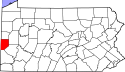 | |
| Boroughs |
| |
| Townships | ||
| Unincorporated communities | ||
| Footnotes | ‡This populated place also has portions in an adjacent county or counties | |
| Counties |  Map of the Pittsburgh Tri-State with green counties in the metropolitan area and yellow counties in the combined area. | |
|---|---|---|
| Major cities | ||
| Cities and towns 15k-50k (in 2010) | ||
| Airports | ||
| Topics | ||
| ||