Big Beaver, Pennsylvania
| Big Beaver, Pennsylvania | |
|---|---|
| Borough | |
 First Primitive Methodist Church of Beaver Falls | |
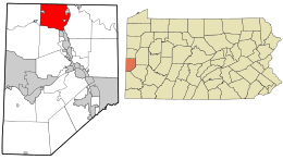 Location in Beaver County and the U.S. state of Pennsylvania. | |
| Coordinates: 40°49′22″N 80°22′11″W / 40.82278°N 80.36972°WCoordinates: 40°49′22″N 80°22′11″W / 40.82278°N 80.36972°W | |
| Country | United States |
| State | Pennsylvania |
| County | Beaver |
| Settled | 1802 |
| Incorporated | 1858 |
| Government | |
| • Type | Borough Council |
| Area[1] | |
| • Total | 18.03 sq mi (46.69 km2) |
| • Land | 17.79 sq mi (46.09 km2) |
| • Water | 0.23 sq mi (0.60 km2) |
| Elevation | 1,089 ft (332 m) |
| Population (2010) | |
| • Total | 1,970 |
| • Estimate (2016)[2] | 1,903 |
| • Density | 106.95/sq mi (41.29/km2) |
| Time zone | UTC-5 (Eastern (EST)) |
| • Summer (DST) | UTC-4 (EDT) |
| Area code(s) | 724 |
| FIPS code | 42-06240 |
Big Beaver is a borough in Beaver County, Pennsylvania, United States. The population was 1,970 at the 2010 census.
Geography
Big Beaver is located at 40°49′22″N 80°22′11″W / 40.82278°N 80.36972°W (40.822723, -80.369682).[3]
According to the United States Census Bureau, the borough has a total area of 18.0 square miles (47 km2), of which, 17.8 square miles (46 km2) of it is land and 0.2 square miles (0.52 km2) of it (1.00%) is water.
Surrounding neighborhoods
Big Beaver has nine borders, including New Beaver in Lawrence County to the north, Koppel to the northeast, North Sewickley Township to the east, Beaver Falls to the southeast, West Mayfield to the south-southeast, Chippewa Township to the south, and Darlington Township and New Galilee to the west. The borough of Homewood is situated entirely within Big Beaver to the southeast.
Demographics
| Historical population | |||
|---|---|---|---|
| Census | Pop. | %± | |
| 1960 | 2,381 | — | |
| 1970 | 2,739 | 15.0% | |
| 1980 | 2,815 | 2.8% | |
| 1990 | 2,298 | −18.4% | |
| 2000 | 2,186 | −4.9% | |
| 2010 | 1,970 | −9.9% | |
| Est. 2016 | 1,903 | [2] | −3.4% |
| Sources:[4][5][6] | |||
As of the census[5] of 2000, there were 2,186 people, 869 households, and 635 families residing in the borough. The population density was 122.7 people per square mile (47.4/km²). There were 905 housing units at an average density of 50.8 per square mile (19.6/km²). The racial makeup of the borough was 98.17% White, 0.69% African American, 0.23% Native American, 0.18% Asian, 0.18% from other races, and 0.55% from two or more races. Hispanic or Latino of any race were 0.78% of the population.
There were 869 households, out of which 26.5% had children under the age of 18 living with them, 63.2% were married couples living together, 7.1% had a female householder with no husband present, and 26.9% were non-families. 23.2% of all households were made up of individuals, and 10.7% had someone living alone who was 65 years of age or older. The average household size was 2.47 and the average family size was 2.90.
In the borough the population was spread out, with 20.1% under the age of 18, 5.5% from 18 to 24, 26.8% from 25 to 44, 29.5% from 45 to 64, and 18.1% who were 65 years of age or older. The median age was 44 years. For every 100 females, there were 95.2 males. For every 100 females age 18 and over, there were 96.3 males.
The median income for a household in the borough was $37,297, and the median income for a family was $43,523. Males had a median income of $34,688 versus $23,945 for females. The per capita income for the borough was $17,228. About 7.0% of families and 9.8% of the population were below the poverty line, including 16.2% of those under age 18 and 4.5% of those age 65 or over.
References
- ↑ "2016 U.S. Gazetteer Files". United States Census Bureau. Retrieved Aug 13, 2017.
- 1 2 "Population and Housing Unit Estimates". Retrieved June 9, 2017.
- ↑ "US Gazetteer files: 2010, 2000, and 1990". United States Census Bureau. 2011-02-12. Retrieved 2011-04-23.
- ↑ "Census of Population and Housing". U.S. Census Bureau. Archived from the original on May 12, 2015. Retrieved 11 December 2013.
- 1 2 "American FactFinder". United States Census Bureau. Archived from the original on 2013-09-11. Retrieved 2008-01-31.
- ↑ "Incorporated Places and Minor Civil Divisions Datasets: Subcounty Resident Population Estimates: April 1, 2010 to July 1, 2012". Population Estimates. U.S. Census Bureau. Archived from the original on June 17, 2013. Retrieved 11 December 2013.
| Wikimedia Commons has media related to Big Beaver, Pennsylvania. |
| Counties |  Map of the Pittsburgh Tri-State with green counties in the metropolitan area and yellow counties in the combined area. | |
|---|---|---|
| Major cities | ||
| Cities and towns 15k-50k (in 2010) | ||
| Airports | ||
| Topics | ||
| ||
Municipalities and communities of Beaver County, Pennsylvania, United States | ||
|---|---|---|
| Cities | 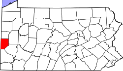 | |
| Boroughs |
| |
| Townships | ||
| Unincorporated communities | ||
| Footnotes | ‡This populated place also has portions in an adjacent county or counties | |