Geography of Iceland
| Native name: Ísland Nickname: Land of Fire and Ice | |
|---|---|
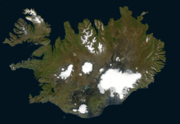 Satellite image of Iceland | |
.svg.png) | |
| Geography | |
| Location | North Europe |
| Coordinates | 65°00′N 18°00′W / 65.000°N 18.000°W |
| Adjacent bodies of water | Atlantic Ocean |
| Area | 103,001 km2 (39,769 sq mi) |
| Area rank | 18th |
| Coastline | 4,970 km (3,088 mi) |
| Highest elevation | 2,110 m (6,920 ft) |
| Highest point | Hvannadalshnúkur |
| Administration | |
| Largest settlement | Reykjavík (pop. 118,861) |
| Demographics | |
| Population | 330,000 (2015) |
| Pop. density | 3.3 /km2 (8.5 /sq mi) |
| Ethnic groups | Icelanders, Poles |
| Additional information | |
| Time zone | |
Iceland is an island country at the confluence of the North Atlantic and Arctic Oceans, east of Greenland and immediately south of the Arctic Circle, atop the constructive boundary of the northern Mid-Atlantic Ridge about 860 km (530 mi) from Scotland and 4,200 km (2,600 mi) from New York City. One of the world's most sparsely populated countries, Iceland's boundaries are almost the same as the main island – the world's 18th largest in area and possessing almost all of the country's area and population. It is the westernmost European country with more land covered by glaciers than in all of continental Europe.
Statistics
Island in North America (commonly regarded as a part of Northern Europe), straddling the Eurasian and North American plates between the Greenland Sea and the North Atlantic Ocean, northwest of the British Isles
Geographic coordinates: 65°00′N 18°00′W / 65.000°N 18.000°W
Extent (locations outside mainland in parentheses)
- North: Rifstangi, 66°32′3" N (Kolbeinsey, 67°08,9 N)
- South: Kötlutangi, 63°23′6" N (Surtsey, 63°17,7 N)
- West: Bjargtangar, 24°32′1" W
- East: Gerpir, 13°29′6" W (Hvalbakur, 13°16,6 W)
Area: 39,769 sq miles (103,001 km²)
- Total: 103,125 km²
- Land: 100,329 km²
- Water: 2,796 km²
- Coastline
- Iceland has a coastline of 4,970 km
- Maritime claims
- Territorial sea: 12 nmi (22.2 km; 13.8 mi)
- Exclusive economic zone: 200 nmi (370.4 km; 230.2 mi)
- Continental shelf: 200 nmi (370.4 km; 230.2 mi) or to the edge of the continental margin
- Elevation extremes
- Lowest point: Jökulsárlón Lagoon: -146 m, Atlantic Ocean 0 m
- Highest point: Hvannadalshnúkur 2,110 m
- Natural resources
Land use
- Arable land: 1.21%
- Permanent crops: 0%
- Other: 98.79% (2012)
- Total renewable water resources
- 170 km3 (2011)
- Freshwater withdrawal (domestic/industrial/agricultural)
- Total: 0.17 km3/yr (49%/8%/42%)
- Per capita: 539.2 m3/yr (2005)
- Natural hazards
Volcanism, earthquakes, avalanches, and glacial lake outburst flooding (or jökulhlaups)
- Environment—current issues
Water pollution from fertilizer runoff; inadequate wastewater treatment
Physical Geography
Iceland consists of eight geographical regions, Capital Region, Southern Peninsula, West, Westfjords, Northwest, Northeast, East and South.[1] Twenty per cent of the land is used for grazing, while only one per cent is cultivated. Iceland has lost most of the woodland that previously covered large areas of the country, but an ambitious reforestation program is currently underway.[2] Fossilized tree pollen and descriptions by the early settlers indicate that prior to human settlement, now thought to have occurred from around the year 800 onwards,[3][4] trees covered between thirty and forty per cent of the island. Today, however, there are only small patches of the original birch forests left, the most prominent being Hallormsstaðaskógur and Vaglaskógur. The country of Iceland contains thirty six islands. The longest river on the island is the Þjórsá at 230 kilometres (about 143 miles).[5] Iceland has three national parks: Vatnajökull National Park, Snæfellsjökull National Park, and Þingvellir National Park.[6]
The inhabited areas are on the coast, particularly in the southwest, while the central highlands are all but uninhabited. The island's terrain is mostly plateau interspersed with mountain peaks, icefields and a coast deeply indented by bays and fjords.
Highlands
The Highlands make up about half of Iceland's land area, which is of recent volcanic origin, and consists of a mountainous lava desert (highest elevation 2,110 m (6,923 ft) above sea level) and other wasteland. The area is mostly uninhabited.
Westfjords
The Westfjords region is composed of a large, mountainous peninsula on Iceland's northwestern coast. The coastline is marked by numerous fjords as it's name suggests. The peninsula contains Iceland's northernmost glacier, Drangajökull.
Southern Peninsula
The Southern Peninsula, also known as the Reykjanes Peninsula, is located in the southwestern corner of Iceland. The area contains little vegetation due to active volcanism and large lava fields. There are hot springs and sulphur springs in the southern portion of the peninsula, in the Kleifarvatn lake and the Krýsuvík geothermal area.
Capital Region
Home to Iceland's capital, Reykjavík, the Capital Region is the most densely populated area in Iceland. It is located on the southwest coast of the island near the Southern Peninsula. The majority of Reykjavik is located on the Seltjarnarnes peninsula. Mount Esja, at 914 m (2,999 ft), is the highest mountain in the vicinity of Reykjavík. Several natural harbours exist, and provide good fishing grounds. [7]
West
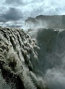
Located in the western portion of the island and north of the Capital Region. In Hvaljörður fjord rests the tallest waterfall in Iceland, Glymur. West is also home to Borgarfjörður, a fjord with volcanic activity such as Deildartunguhver- a powerful hotspring. The 804 metre Hafnarfjall Mountain rises over the landscape.[8]
South
The southern portion of Iceland contains some of it's most notable volcanoes such as Hekla, Eldgjá and Katla. Alongside the volcanoes exist numerous glaciers such as Vatnajökull, Mýrdalsjökull and Eyjafjallajökull. Basalt columns and black sand beaches are examples of the volcanic activity of the area.[9] The area also contains mountain ranges and Iceland's highest peak, Hvannadalshnjúkur, as well as the Vestmannaeyjar (Westman Islands) archipelago.
East
East Iceland contains the majority of the island's vegetation and birch forests.
Glaciers
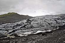
Around 10.2 per cent of the total land area is covered by glaciers, although these are now retreating at an accelerating rate.[10] The four largest Icelandic glaciers are:
- Vatnajökull (7,764 km²)
- Langjökull (868 km²)
- Hofsjökull (827 km²)
- Mýrdalsjökull (542 km²)
Other notable glaciers include:
- Drangajökull (145 km²)
- Eyjafjallajökull (70 km²)
- Tungnafellsjökull (33 km²)
- Þórisjökull (25 km²)
- Eiríksjökull (21 km²)
- Þrándarjökull (16 km²)
- Tindfjallajökull (11 km²)
- Torfajökull (10 km²)
- Snæfellsjökull (10 km²).
Climate

Because of the Gulf Stream's moderating influence, the climate is temperate and characterized by damp, cool summers and relatively mild but windy winters. Reykjavík has an average temperature of 12 °C (53.6 °F) in July and 1 °C (34 °F) in January[11] Köppen Climate Classification of Subpolar oceanic climate (Cfc) with most of the island classified as Tundra (ET)
Geology
Iceland has extensive volcanic and geothermal activity. The rift associated with the Mid-Atlantic Ridge, which marks the division between the Eurasian Plate and North American tectonic plates, runs across Iceland from the southwest to the northeast. This geographic feature is prominent at the Þingvellir National Park, where the promontory creates an extraordinary natural amphitheatre. The site was the home of Iceland's parliament, the Alþing, which was first convened in the year 930. It is a common misconception that Þingvellir is at the juncture between the North American and Eurasian continental plates. However, they are in fact at the juncture of the North American continental plate and a smaller plate (approx. 10,000 km2) called the Hreppar Microplate (Hreppaflekinn).[12] From 1963 to 1967, the island of Surtsey was created on the southwest coast by a volcanic eruption.
Geological activity
A geologically young land, Iceland is located on both the Iceland hotspot and the Mid-Atlantic Ridge, which runs right through it. This location means that the island is highly geologically active with earthquakes and many volcanoes, notably Hekla, Eldgjá, Herðubreið and Eldfell. Eyjafjallajökull (1,666 m) erupted in 2010, disrupting European air traffic.[13]
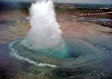
Iceland has many geysers, including Geysir, from which the English word geyser is derived.
With the widespread availability of geothermal power, and the harnessing of many rivers and waterfalls for hydroelectricity, most residents have access to inexpensive hot water, heating and electricity.
The island is composed primarily of basalt, a low-silica lava associated with effusive volcanism as has occurred also in Hawaii. Iceland, however, has a variety of volcanic types (composite and fissure), many producing more evolved lavas such as rhyolite and andesite. Iceland has hundreds of volcanoes with approximately thirty volcanic systems active.[14]
Environment—international agreements
Party to:
- Air Pollution, Air Pollution-Persistent Organic Pollutants, Biodiversity, Climate Change, Desertification, Endangered Species, Hazardous Wastes, Law of the Sea, Marine Dumping, Nuclear Test Ban, Ozone Layer Protection, Ship Pollution (MARPOL 73/78), Wetlands, Whaling
Signed, but not ratified:
Antipodes
Iceland is not antipodal to any land mass. The closest are the Balleny Islands off Antarctica, claimed by New Zealand. The antipodes of the northernmost of these, Young Island, lie between Flatey and Grímsey islands off the north-central Icelandic coast, about 10 km from either.
Maps and images
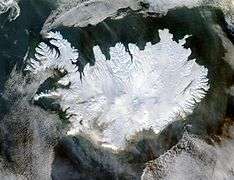 True colour satellite image of Iceland in winter
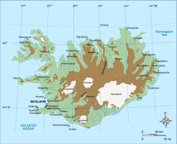
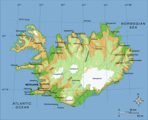 Map of Iceland showing major towns and geographical features
 Active volcanic areas and systems in Iceland
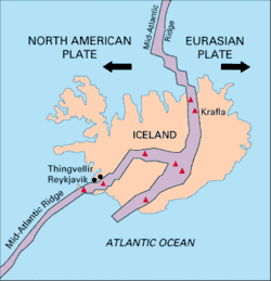 Map showing the Mid-Atlantic Ridge splitting Iceland and separating the North American and Eurasian Plates
 Ridge between the tectonic plates of Eurasia and North America
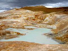 Iceland is rich in sulfur deposits.
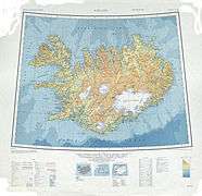 Topographic map of Iceland
See also
- Extreme points of Europe
- Highlands of Iceland
- Iceland hotspot
- Iceland plume
- List of earthquakes in Iceland
- List of extreme points of Iceland
- List of fjords of Iceland
- List of islands of Iceland
- List of lakes of Iceland
- List of national parks of Iceland
- List of rivers of Iceland
- List of valleys of Iceland
- List of waterfalls of Iceland
References
- ↑ "Iceland Regions - Iceland On The Web". www.icelandontheweb.com (in Icelandic). Retrieved 2018-10-01.
- ↑ "Forestry in a treeless land". Iceland Forest Service. Retrieved 12 October 2015.
- ↑ http://www.rae.ac.uk/submissions/ra1.aspx?id=187&type=hei&subid=3463
- ↑ "New View on the Origin of First Settlers in Iceland". Iceland Review Online. 4 June 2011. Retrieved 12 October 2015.
- ↑ "Þjórsá | Guide to Iceland". Guide to Iceland. Retrieved 2018-09-20.
- ↑ "National parks in Iceland". Inspired By Iceland. Retrieved 2018-09-20.
- ↑ "Iceland | Culture, History, & People". Encyclopedia Britannica. Retrieved 2018-10-02.
- ↑ Iceland, West. "the-classic-circle | Visit West Iceland". Visit West Iceland. Retrieved 2018-10-02.
- ↑ "Reynisfjara Black Sand Beach | Guide to Iceland". Guide to Iceland. Retrieved 2018-10-02.
- ↑ "Heildarstærð jökla á Íslandi 2014 ("Total surface area of Icelandic glaciers 2014")" (PDF). Loftmyndir ehf. Archived from the original (PDF) on 17 March 2015. Retrieved 12 October 2015.
- ↑ "Mánaðarmeðaltöl fyrir stöð 1 – Reykjavík ("Monthly data for station No 1 – Reykjavík")". Retrieved 12 October 2015.
- ↑ "Plate boundaries, rifts and transforms in Iceland" (PDF). JÖKULL No. 58, 2008. Institute of Earth Sciences, University of Iceland. Retrieved 19 March 2014.
- ↑ "The World Factbook — Central Intelligence Agency". www.cia.gov. Retrieved 2018-09-17.
- ↑ Carmichael, I.S.E. (1964). "The Petrology of Thingmuli, a Tertiary Volcano in Eastern Iceland" (PDF). Journal of Petrology. 5 (3): 435–460. doi:10.1093/petrology/5.3.435.
External links

- Iceland at the CIA World Factbook
![]()