Hofsjökull
| Hofsjökull | |
|---|---|
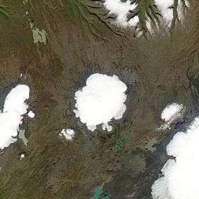 Satellite image of Hofsjökull. | |
| Highest point | |
| Elevation | 1,782 metres (5,846 ft) |
| Prominence | ≈1100 m |
| Coordinates | 64°49′N 18°49′W / 64.817°N 18.817°W |
| Geography | |
| Location | Southwestern Iceland |
| Geology | |
| Age of rock | Holocene |
| Mountain type | Subglacial shield volcano with caldera |
Hofsjökull (Icelandic: “temple glacier”) is the third largest glacier in Iceland after Vatnajökull and Langjökull and the largest active volcano in the country.[1] It is situated in the west of the Highlands of Iceland and north of the mountain range Kerlingarfjöll, between the two largest glaciers of Iceland. It covers an area of 925 km2, reaching 1,765 m (5,791 ft) at its summit.[2] The subglacial volcano is a shield type with caldera.[3]
Hofsjökull is the source of several rivers including the Þjórsá, Iceland's longest river.[4]
In the southeast of Iceland, between the easternmost glacier tongue of Vatnajökull (Axajökull) and Þrándarjökull, is a smaller glacier (area about 4 km²), which is also called Hofsjökull.
In 2015, Hofsjökull increased in mass, the first time in 20 years this had happened.[5]
See also
Notes
- ↑ Thordarson & Hoskuldsson, p. 72
- ↑ National Land Survey of Iceland (2001), National Land Survey of Iceland – Geographical information, archived from the original on 2010-04-06, retrieved 2008-08-14 /
- ↑ Thordarson & Hoskuldsson, p. 29
- ↑ Thordarson & Hoskuldsson, p. 83
- ↑ http://en.vedur.is/about-imo/news/nr/3229
References
- Thordurson, Thor; Hoskuldsson, Armann (2002), Classic Geology in Europe 3: Iceland, Harpenden, England: Terra Publishing, ISBN 1-903544-06-8
External links
| Wikimedia Commons has media related to Hofsjökull. |
- Hofsjökull in the Catalogue of Icelandic Volcanoes
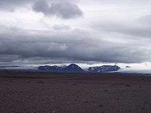
- (Photo)
Coordinates: 64°49′N 18°49′W / 64.817°N 18.817°W