Geology of Iceland
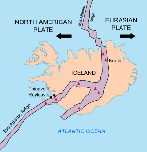
The geology of Iceland is unique and of particular interest to geologists. Iceland lies on the divergent boundary between the Eurasian plate and the North American plate. It also lies above a hotspot, the Iceland plume. The plume is believed to have caused the formation of Iceland itself, the island first appearing over the ocean surface about 16 to 18 million years ago.[1][2] The result is an island characterized by repeated volcanism and geothermal phenomena such as geysers.
The eruption of Laki in 1783 caused much devastation and loss of life, leading to a famine that killed approximately 25% of the island's human population[3] and resulting in a drop in global temperatures, as sulfur dioxide was spewed into the Northern Hemisphere. This caused crop failures in Europe and may have caused droughts in India. The eruption has been estimated to have killed over six million people globally,[4] making it one of the deadliest volcanoes, with Tambora being number one.
In the period from 1963 to 1967, the new island of Surtsey was created on the southwest coast by a volcanic eruption.
Geologic history
Opening of the North Atlantic
- Iceland plume
- Iceland hotspot
- Rifting of the north Atlantic
Glaciations
- Glacier extent
- Nunataks and ice free areas
- Interglacials
- Tuyas and subcanism
Holocene changes and volcanism
- Revegetation
- Increased volcanism
- Soil formation
- Isostatic rebound
- Holocene sediments
- Coastal erosion
Rock types
Volcanic deposits
- Tholeiitic volcanic series
- Alkalic volcanic series
- Hyaloclastite
- Tephras and ash
Intrusive rocks
- Dikes
- Sills
- Plutons
Sedimentary deposits
One of the rare examples of sedimentary rocks in Iceland is the sequence of marine and non-marine sediments present on the Tjörnes Peninsula in northern Iceland. These Pliocene and late Pleistocene deposits are composed of silt and sandstones, with fossils preserved in the lower layers.[5] The primary fossil types found in the Tjörnes beds are marine mollusk shells and plant remains (lignite).
- Vegetational changes
- Past climate
- Origin of the strata
- Fossil preservation
Active tectonics
The tectonic structure of Iceland is characterized by various seismically and volcanically active centers. Iceland is bordered to the south by the Reykjanes Ridge segment of the Mid-Atlantic Ridge and to the north by the Kolbeinsey Ridge. Rifting in the southern part of Iceland is focused in two main parallel rift zones. The Reykjanes Peninsula Rift in SW Iceland is the landward continuation of the Reykjanes Ridge that connects to the Western Volcanic Zone (WVZ). The more active Eastern Volcanic Zone (EVZ) represents a rift jump, although it is unclear how the eastward propagation of the main rifting activity has occurred. [6] The offset between the WVZ and the EVZ is accommodated by the South Iceland Seismic Zone, an area characterized by high earthquake activity. The EVZ transitions northward into the Northern Volcanic Zone (NVZ), which contains Krafla volcano. The NVZ is connected to the Kolbeinsey Ridge by the Tjörnes Fracture Zone, another major center of seismicity and deformation.
Glacial geology
Glaciers cover approximately 11% of Iceland, the largest of which being Vatnajökull. As many glaciers overlie active volcanoes, subglacial eruptions can pose hazards due to sudden floods produced by glacial meltwater, known as jökulhlaups. Icelandic glaciers have generally been retreating over the past 100 years, with Vatnajökull having lost as much as 10% of its volume.[7]
Human impact and natural catastrophes
See also
- Geography of Iceland
- Geological deformation of Iceland
- Geothermal power in Iceland
- Iceland plume
- List of fjords of Iceland
- List of glaciers of Iceland
- List of islands of Iceland
- List of lakes of Iceland
- List of rivers of Iceland
- List of volcanoes in Iceland
- List of waterfalls of Iceland
- Volcanology of Iceland
References
- ↑ Tobias Weisenberger (2013). "Introduction to the geology of Iceland".
- ↑ "Catalogue of the Active Volcanoes of the World, Vol. 24" (PDF). Archived from the original (PDF) on 2013-11-13. Retrieved 2012-08-01.
- ↑ Gunnar Karlsson (2000), Iceland's 1100 Years, p. 181
- ↑ How The Earth Was Made: The Age of Earth (video), History.com
- ↑ Símonarson, L. A., & Eiríksson, J. (2008). "Tjörnes-Pliocene and Pleistocene sediments and faunas" (PDF). Jökull. 58: 331–342.
- ↑ Einarsson, Páll (2008). "Plate boundaries, rifts and transforms in Iceland" (PDF). Jökull. 58: 35–58.
- ↑ Björnsson, H., & Pálsson, F. (2008). "Icelandic glaciers" (PDF). Jökull. 58: 365–386.
External links
- Maps and illustrative photos from Union College
- Trønnes, R.G. 2002: Field trip: Introduction. Geology and geodynamics of Iceland. In: S. Planke (ed.) Iceland 2002 – Petroloeum Geology Field Trip Guide, prepared for Statoil Faroes Licence Groups by Volcanic Basin Petroleum Research, Nordic Volcanological Institute and Iceland National Energy Authority, p. 23-43.
- Thor Thordarson. Outline of Geology of Iceland. Chapman Conference 2012
- Bamlett M. and J.F. Potter (1994) "Iceland". Geologists' Association Guide No.52.