Balleny Islands
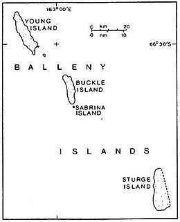 Map of the Balleny Islands | |
 Balleny Islands Location in Antarctica | |
| Geography | |
|---|---|
| Location | Antarctica |
| Coordinates | 66°55′S 163°45′E / 66.917°S 163.750°ECoordinates: 66°55′S 163°45′E / 66.917°S 163.750°E |
| Archipelago | Balleny Islands |
| Area | 800 km2 (310 sq mi) |
| Highest elevation | 1,705 m (5,594 ft) |
| Highest point | Brown Peak[1][2] |
| Administration | |
| Administered under the Antarctic Treaty System | |
| Demographics | |
| Population | Uninhabited |
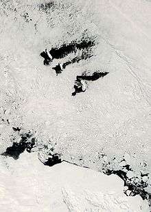
The Balleny Islands (66°55′S 163°45′E / 66.917°S 163.750°E) are a series of uninhabited islands in the Southern Ocean extending from 66°15' to 67°35'S and 162°30' to 165°00'E. The group extends for about 160 km (99 mi) in a northwest-southeast direction. The islands are heavily glaciated and of volcanic origin. Glaciers project from their slopes into the sea. The islands were formed by the so-called Balleny hotspot.
The group includes three main islands: Young, Buckle and Sturge, which lie in a line from northwest to southeast, and several smaller islets and rocks:
- northeast of Young Island: Seal Rocks, Pillar
- southeast of Young Island: Row Island, Borradaile Island (with Swan Base shelter hut)
- south of Buckle Island: Scott Cone, Chinstrap Islet, Sabrina Islet (with Sabrina Refuge shelter hut), and The Monolith
The islands are part of the Ross Dependency, claimed by New Zealand (see Territorial claims in Antarctica).
Islands and rocks from north to south
| Island/Rock | Area | Highest peak | ||
|---|---|---|---|---|
| km2 | sq mi | m | ft | |
| Young Island and satellite islets | ||||
| Seal Rocks | 0.0 | 0 | 15 | 49 |
| Pillar | 0.0 | 0 | 51 | 167 |
| Young Island | 255.4 | 98.6 | 1,340 | 4,400 (Freeman Peak) |
| Row Island | 1.7 | 0.66 | 183 | 600 |
| Borradaile Island | 3.5 | 1.4 | 381 | 1,250 |
| Beale Pinnacle | 0.0 | 0 | 61 | 200 |
| Buckle Island and satellite islets | ||||
| Buckle Island | 123.6 | 47.7 | 1,238 | 4,062 |
| Scott Cone | 0.0 | 0 | 31 | 102 |
| Eliza Cone | 0.0 | 0 | 67 | 220 |
| Chinstrap Islet | 0.0 | 0 | ||
| Sabrina Island | 0.2 | 0.077 | 90 | 300 |
| The Monolith | 0.1 | 0.039 | 79 | 259 |
| Sturge Island (no satellite islets) | ||||
| Sturge Island | 437.4 | 168.9 | 1,705[1] or 1524[2] |
5,594 or 5,000 (Brown Peak) |
The Antarctic Circle is close to Borradaile Island, in the eight kilometre channel between Young and Buckle Islands. Buckle Island and the nearby Sabrina Islet are home to several colonies of Adelie and chinstrap penguins.
The English whaling captains John Balleny and Thomas Freeman first sighted the group during 1839:[3] Balleny named the island group after himself and the individual islands after the London merchants whose financial backing had made the expedition possible. Freeman was the first person to land on any of the islands on 9 February 1839, and it was the first landing south of the Antarctic Circle. The islands' area totals 400 km2 (154 sq mi) and the highest point has been measured as 1,705 m (5,594 ft)[1] or approximately 1500m (5000 feet)[2] (the unclimbed Brown Peak on Sturge Island). Sealers sighted the islands in 1853 but did not land.[4]
Geology
In the archipelago, the Buckle, Sturge and Young Islands are examples of stratovolcanoes.[5] Strong earthquakes very close to the islands are rare, but tremors of moderate strength do occur over the Pacific–Antarctic Ridge, Macquarie Triple Junction and Pacific Rim between the Balleny Islands and Macquarie Island.[6] Other earthquakes occur near the Southeast Indian Ridge and Balleny Fracture Zone, including a magnitude 8.1 earthquake in 1998 that struck just over 700 km (430 mi) west-northwest of the Islands.[7]
See also
References
| Wikimedia Commons has media related to Balleny Islands. |
- W.E. LeMasurier; J.W. Thomson (1990). Volcanoes of the Antarctic Plate and Southern Oceans. American Geophysical Union. pp. 512 pp. ISBN 0-87590-172-7.
- 1 2 3 Brown Peak, Composite Gazetteer of Antarctica, Scientific Committee on Antarctic Research. US source.
- 1 2 3 Brown Peak, Composite Gazetteer of Antarctica, Scientific Committee on Antarctic Research. NZ source.
- ↑ Gunter Faure, Teresa M. Mensing, The Transantarctic Mountains: Rocks, Ice, Meteorites and Water (Springer, 2010), 555.
- ↑ R.K. Headland (ed.) Historical Antarctic sealing industry, Scott Polar Research Institute, University of Cambridge, 2018, p.169 ISBN 978-0-901021-26-7
- ↑ GVP, Smithsonian. "Volcanoes of Antarctica – Antarctica and South Sandwich Islands". Smithsonian Institution National Museum of Natural History Global Volcanism Program. Archived from the original on 14 May 2011. Retrieved 17 April 2011.
- ↑ Earthquakes, USGS. "World Seismicity Maps: South Pole". United States Geological Survey. Earthquake Hazards Program. Retrieved 17 April 2011.
- ↑ USGS. "M 8.1 – Balleny Islands region". United States Geological Survey. Retrieved 6 August 2017.