Capital Region (Iceland)
| Capital Region Höfuðborgarsvæðið | |
|---|---|
| Capital region | |
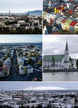 From upper left: Reykjavík from Perlan, rooftops from Hallgrímskirkja, Reykjavík from Hallgrímskirkja, Fríkirkjan, panorama from Perlan | |
 | |
| Coordinates: 64°11′05″N 21°36′47″W / 64.1846°N 21.6131°W | |
| Country | Iceland |
| Area | |
| • Total | 1,062.2 km2 (410.1 sq mi) |
| Population (2017) | |
| • Total | 222,590 |
| • Density | 204.2/km2 (529/sq mi) |
| Time zone | UTC+0:00 (GMT) |

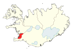
Greater Reykjavík (Icelandic: Höfuðborgarsvæðið, meaning "The Capital Region") is a region in southwestern Iceland that comprises the national capital Reykjavík and six municipalities around it.[1][2] Each municipality has its own elected council. Municipal governments cooperate extensively in various fields: for example waste policy, shared public transport and a joint fire brigade.
The area is by far the largest urban area in Iceland.[3] Greater Reykjavík's population of 216 940 is over 60% of the population of Iceland, in an area that is only just over 1% of the total size of the country. The size of the greater Reykjavík area is calculated from the area of its constituent municipalities, including large areas of hinterland, not the much smaller urban core of about 200 km2 (77 sq mi) [4]
Population and size
Of the seven municipalities that make up the Greater Reykjavík area, Reykjavík is by far the most populated with 122,460 inhabitants; Kjósarhreppur is the least populated with only 217 residents, but has the largest area: 287.7 km2 (111.1 sq mi). Seltjarnarnes is the smallest municipality with an area of 2.3 km2 (0.89 sq mi).
| Municipalities | Population[5] | Area (km2)[6] | Density (Pop/km2) |
|---|---|---|---|
| Reykjavík | 127,220 | 277.1 | 459.1 |
| Kópavogur | 35,980 | 83.7 | 429 |
| Hafnarfjörður | 28,200 | 143.3 | 197 |
| Garðabær | 15,700 | 74.4 | 211 |
| Mosfellsbær | 9,075 | 193.7 | 46.85 |
| Seltjarnarnes | 4,590 | 2.3 | 1,995 |
| Kjósarhreppur | 221 | 287.7 | 0.77 |
| Total | 220,986 | 1,062.2 | 203.48 |
References
- ↑ Association of municipalities in the Capital area English version Retrieved on 5. June 2010
- ↑ Sigurður Guðmundsson. „Hvernig eru hugtökin dreifbýli og landsbyggð skilgreind hér á landi?“ The Icelandic Web of Science. 18.8.2000. Retrieved on 6. June 2010 (In Icelandic)
- ↑ Statistics Iceland. Population by municipalities Archived 2012-04-17 at the Wayback Machine.. Retrieved on 5. June 2010
- ↑ Emilía Dagný Sveinbjörnsdóttir. „Hvað er Stór-Reykjavíkur svæðið stórt sem hlutfall af öllu landinu?“. The Icelandic Web of Science. 28.3.2002. Retrieved on 6. June 2010 (In Icelandic)
- ↑ Statistics Iceland. Population by municipalities Archived 2012-04-17 at the Wayback Machine.. Retrieved on 17. March 2012
- ↑ National Land Survey of Iceland. Sveitarfélagaskjárinn. Retrieved on 6. June 2010 (In Icelandic)
External links

Coordinates: 64°08′00″N 21°56′00″W / 64.13333°N 21.93333°W