Geography of the Faroe Islands
.jpg)
The Faroe Islands are an island group consisting of eighteen islands between the Norwegian Sea and the North Atlantic, about half-way between Iceland and Norway. Its coordinates are 62°N 7°W / 62°N 7°W. It is 1,393 square kilometres in area, and includes small lakes and rivers, but no major ones. There are 1,117 kilometres of coastline, and no land boundaries with any other country.
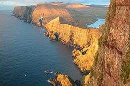
The Faroe Islands generally have cool summers and mild winters, with a usually overcast sky and frequent fog and strong winds. Although at a high latitude, due to the Gulf Stream their climate is ameliorated. The islands are rugged and rocky with some low peaks; the coasts are mostly bordered by cliffs. The Faroe Islands are notable for having the highest sea cliffs in Europe, and some of the highest in the world otherwise. The lowest point is at sea level, and the highest is at Slættaratindur, which is 882 metres above sea level. The landscape made roadbuilding difficult, and only recently has this been remedied by building tunnels.
Many of the Faroese islands tend to be elongated in shape. Natural resources include fish and hydropower.
Statistics
- Geographic coordinates
-
- 62°00′N 06°47′W / 62.000°N 6.783°W
- North: Enniberg, 62°29′,2 N
- South: Sumbiarsteinur, 61°21′,6 N
- West: Gáadrangur, 7°40′,1 W
- East: Stapin, 6°21′,5 W
- Area
- Land boundaries
- 0 km
- Coastline
- 1,117 km
- Maritime claims
-
- Territorial sea: 3 nmi (5.6 km; 3.5 mi)
- Continental shelf: 200 nmi (370.4 km; 230.2 mi) or agreed boundaries or median line
- Exclusive economic zone: 200 nmi (370.4 km; 230.2 mi) or agreed boundaries or median line
- Climate
- Subarctic oceanic climate (Köppen climate classification Cfc) moderated by North Atlantic Current; long, mild, windy winters; short, cool summers, damp in the South and West. Arctic climate (Köppen ET) in some mountains.
- Terrain
- Rugged, rocky, some low peaks; cliffs along most of coast. The coasts are deeply indented with fjords, and the narrow passages between islands are agitated by strong tidal currents.
- Elevation extremes
-
- Lowest point: Atlantic Ocean 0 m
- Highest point: Slættaratindur 880 m
- Natural resources
- Fish, whales, hydropower, wind, possible petroleum and gas
- Land use
-
- Arable land: 2.14%
- Permanent crops: 0%
- Other: 97.86% (2012)
- Environment—international agreements
- Marine dumping
Climate
| Climate data for Tórshavn (1981–2010, extremes 1961–2010) | |||||||||||||
|---|---|---|---|---|---|---|---|---|---|---|---|---|---|
| Month | Jan | Feb | Mar | Apr | May | Jun | Jul | Aug | Sep | Oct | Nov | Dec | Year |
| Record high °C (°F) | 11.6 (52.9) |
12.0 (53.6) |
12.3 (54.1) |
18.3 (64.9) |
19.7 (67.5) |
20.0 (68) |
20.2 (68.4) |
22.0 (71.6) |
19.5 (67.1) |
15.2 (59.4) |
14.7 (58.5) |
13.2 (55.8) |
22.0 (71.6) |
| Average high °C (°F) | 5.8 (42.4) |
5.6 (42.1) |
6.0 (42.8) |
7.3 (45.1) |
9.2 (48.6) |
11.1 (52) |
12.8 (55) |
13.1 (55.6) |
11.5 (52.7) |
9.3 (48.7) |
7.2 (45) |
6.2 (43.2) |
8.8 (47.8) |
| Daily mean °C (°F) | 4.0 (39.2) |
3.6 (38.5) |
4.0 (39.2) |
5.2 (41.4) |
7.0 (44.6) |
9.0 (48.2) |
10.7 (51.3) |
11.0 (51.8) |
9.6 (49.3) |
7.5 (45.5) |
5.5 (41.9) |
4.3 (39.7) |
6.8 (44.2) |
| Average low °C (°F) | 1.7 (35.1) |
1.3 (34.3) |
1.7 (35.1) |
3.0 (37.4) |
5.1 (41.2) |
7.1 (44.8) |
9.0 (48.2) |
9.2 (48.6) |
7.6 (45.7) |
5.4 (41.7) |
3.4 (38.1) |
2.1 (35.8) |
4.7 (40.5) |
| Record low °C (°F) | −8.8 (16.2) |
−11.0 (12.2) |
−9.2 (15.4) |
−9.9 (14.2) |
−3.0 (26.6) |
0.0 (32) |
1.5 (34.7) |
1.5 (34.7) |
−0.6 (30.9) |
−4.5 (23.9) |
−7.2 (19) |
−10.5 (13.1) |
−11.0 (12.2) |
| Average precipitation mm (inches) | 157.7 (6.209) |
115.2 (4.535) |
131.6 (5.181) |
89.5 (3.524) |
63.3 (2.492) |
57.5 (2.264) |
74.3 (2.925) |
96.0 (3.78) |
119.5 (4.705) |
147.4 (5.803) |
139.3 (5.484) |
135.3 (5.327) |
1,321.3 (52.02) |
| Average precipitation days (≥ 1.0 mm) | 22 | 17 | 21 | 16 | 13 | 12 | 13 | 13 | 18 | 22 | 21 | 22 | 210 |
| Average snowy days (≥ 0.1 mm) | 8.3 | 6.6 | 8.0 | 4.4 | 1.5 | 0 | 0 | 0 | 0.1 | 1.4 | 5.5 | 8.2 | 44 |
| Average relative humidity (%) | 90 | 89 | 89 | 87 | 88 | 88 | 90 | 90 | 90 | 90 | 89 | 90 | 89 |
| Mean monthly sunshine hours | 14 | 36 | 71 | 106 | 124 | 125 | 111 | 98 | 80 | 49 | 20 | 6 | 840 |
| Source #1: Danish Meteorological Institute[3] | |||||||||||||
| Source #2: NOAA (sun, humidity and precipitation days 1961–1990)[4][5] Danish Meteorological Institute[6] | |||||||||||||
Tórshavn receives frosts more often than other areas just a short distance to the south. Snow is also seen at a much higher frequency than outlying islands nearby. The area receives on average 49 frosts a year.[3]
| Climate data for Mykines, 105 m.a.s.l. | |||||||||||||
|---|---|---|---|---|---|---|---|---|---|---|---|---|---|
| Month | Jan | Feb | Mar | Apr | May | Jun | Jul | Aug | Sep | Oct | Nov | Dec | Year |
| Record high °C (°F) | 9.0 (48.2) |
9.5 (49.1) |
10.0 (50) |
12.5 (54.5) |
13.0 (55.4) |
15.0 (59) |
16.0 (60.8) |
16.0 (60.8) |
14.0 (57.2) |
11.5 (52.7) |
10.6 (51.1) |
9.5 (49.1) |
16.0 (60.8) |
| Average high °C (°F) | 5.1 (41.2) |
5.1 (41.2) |
5.2 (41.4) |
6.6 (43.9) |
8.0 (46.4) |
10.2 (50.4) |
10.9 (51.6) |
11.3 (52.3) |
10.2 (50.4) |
8.8 (47.8) |
6.0 (42.8) |
4.9 (40.8) |
7.7 (45.9) |
| Daily mean °C (°F) | 3.5 (38.3) |
3.5 (38.3) |
3.5 (38.3) |
4.8 (40.6) |
6.2 (43.2) |
8.5 (47.3) |
9.2 (48.6) |
9.6 (49.3) |
8.7 (47.7) |
7.4 (45.3) |
4.6 (40.3) |
3.3 (37.9) |
6.1 (43) |
| Average low °C (°F) | 1.7 (35.1) |
1.5 (34.7) |
1.5 (34.7) |
3.0 (37.4) |
4.7 (40.5) |
7.1 (44.8) |
7.8 (46) |
8.2 (46.8) |
7.3 (45.1) |
5.7 (42.3) |
2.7 (36.9) |
1.5 (34.7) |
4.4 (39.9) |
| Record low °C (°F) | −7.0 (19.4) |
−11.0 (12.2) |
−8.0 (17.6) |
−10.0 (14) |
−2.6 (27.3) |
1.0 (33.8) |
4.1 (39.4) |
4.2 (39.6) |
0.4 (32.7) |
−5.0 (23) |
−7.0 (19.4) |
−7.0 (19.4) |
−11.0 (12.2) |
| Average precipitation mm (inches) | 77 (3.03) |
56 (2.2) |
88 (3.46) |
53 (2.09) |
31 (1.22) |
49 (1.93) |
47 (1.85) |
61 (2.4) |
96 (3.78) |
95 (3.74) |
80 (3.15) |
90 (3.54) |
823 (32.4) |
| Average precipitation days (≥ 1.0 mm) | 17 | 12 | 18 | 13 | 9.2 | 12 | 12 | 11 | 15 | 18 | 16 | 19 | 171 |
| Average relative humidity (%) | 82 | 81 | 83 | 83 | 84 | 87 | 86 | 87 | 85 | 84 | 81 | 80 | 84 |
| Source: Danish Meteorological Institute[7] | |||||||||||||
While receiving more frost than most of the Faroe Islands, Mykines is more temperate in the winter than nearby Vágar. Snow is also less common despite the relatively lower winter temperatures due to the relatively low precipitation in the area. It also has a very mild tundra climate bordering on subpolar oceanic. Frost occurs on 46 days in an average year[7] It is also likely that the lower areas of the island experience less than this, as the weather station is located at 105 meters above sea level.[7]
| Climate data for Akraberg, Suðuroy, 101 m.a.s.l. | |||||||||||||
|---|---|---|---|---|---|---|---|---|---|---|---|---|---|
| Month | Jan | Feb | Mar | Apr | May | Jun | Jul | Aug | Sep | Oct | Nov | Dec | Year |
| Record high °C (°F) | 9.6 (49.3) |
8.8 (47.8) |
9.2 (48.6) |
13.0 (55.4) |
15.2 (59.4) |
17.2 (63) |
17.6 (63.7) |
18.4 (65.1) |
17.2 (63) |
11.8 (53.2) |
10.8 (51.4) |
9.8 (49.6) |
18.4 (65.1) |
| Average high °C (°F) | 5.4 (41.7) |
5.4 (41.7) |
5.5 (41.9) |
6.5 (43.7) |
8.1 (46.6) |
9.9 (49.8) |
11.1 (52) |
11.4 (52.5) |
10.2 (50.4) |
8.8 (47.8) |
6.6 (43.9) |
5.8 (42.4) |
7.9 (46.2) |
| Daily mean °C (°F) | 3.8 (38.8) |
3.9 (39) |
4.0 (39.2) |
4.8 (40.6) |
6.6 (43.9) |
8.4 (47.1) |
9.6 (49.3) |
10.0 (50) |
8.9 (48) |
7.5 (45.5) |
5.1 (41.2) |
4.2 (39.6) |
6.4 (43.5) |
| Average low °C (°F) | 1.9 (35.4) |
2.0 (35.6) |
2.0 (35.6) |
2.9 (37.2) |
5.0 (41) |
6.9 (44.4) |
8.1 (46.6) |
8.5 (47.3) |
7.2 (45) |
5.8 (42.4) |
3.2 (37.8) |
2.2 (36) |
4.6 (40.3) |
| Record low °C (°F) | −7.2 (19) |
−10.6 (12.9) |
−7.0 (19.4) |
−9.3 (15.3) |
−4.0 (24.8) |
0.0 (32) |
2.0 (35.6) |
3.0 (37.4) |
0.0 (32) |
−2.6 (27.3) |
−5.6 (21.9) |
−8.4 (16.9) |
−10.6 (12.9) |
| Average precipitation mm (inches) | 90 (3.54) |
60 (2.36) |
77 (3.03) |
48 (1.89) |
43 (1.69) |
51 (2.01) |
65 (2.56) |
65 (2.56) |
94 (3.7) |
108 (4.25) |
90 (3.54) |
95 (3.74) |
884 (34.8) |
| Average precipitation days (≥ 1.0 mm) | 18 | 13 | 17 | 12 | 10 | 11 | 12 | 12 | 16 | 18 | 17 | 19 | 173 |
| Average relative humidity (%) | 85 | 85 | 85 | 85 | 88 | 89 | 91 | 91 | 89 | 87 | 84 | 84 | 87 |
| Source: Danish Meteorological Institute[8] | |||||||||||||
Akraberg is milder than much of the Faroe Islands and experiences frost on 38 days in an average year,[8] possibly less in lower areas, as the weather station is located at an elevation of 101 meters above sea level.[8]
| Climate data for Vágar Airport, Vágar, 84 m.a.s.l. | |||||||||||||
|---|---|---|---|---|---|---|---|---|---|---|---|---|---|
| Month | Jan | Feb | Mar | Apr | May | Jun | Jul | Aug | Sep | Oct | Nov | Dec | Year |
| Record high °C (°F) | 10.3 (50.5) |
9.5 (49.1) |
12.5 (54.5) |
14.8 (58.6) |
20.8 (69.4) |
21.6 (70.9) |
24.0 (75.2) |
23.5 (74.3) |
20.5 (68.9) |
14.0 (57.2) |
12.0 (53.6) |
12.2 (54) |
24.0 (75.2) |
| Average high °C (°F) | 4.8 (40.6) |
4.8 (40.6) |
5.2 (41.4) |
6.4 (43.5) |
8.8 (47.8) |
10.8 (51.4) |
12.1 (53.8) |
12.3 (54.1) |
10.4 (50.7) |
8.6 (47.5) |
6.1 (43) |
5.3 (41.5) |
8.0 (46.4) |
| Daily mean °C (°F) | 2.7 (36.9) |
2.7 (36.9) |
3.1 (37.6) |
4.3 (39.7) |
6.6 (43.9) |
8.7 (47.7) |
10.2 (50.4) |
10.4 (50.7) |
8.6 (47.5) |
6.8 (44.2) |
4.2 (39.6) |
3.3 (37.9) |
6.0 (42.8) |
| Average low °C (°F) | 0.5 (32.9) |
0.6 (33.1) |
0.9 (33.6) |
2.1 (35.8) |
4.4 (39.9) |
6.6 (43.9) |
8.3 (46.9) |
8.5 (47.3) |
6.7 (44.1) |
4.8 (40.6) |
2.1 (35.8) |
1.1 (34) |
3.9 (39) |
| Record low °C (°F) | −10.0 (14) |
−11.7 (10.9) |
−10.6 (12.9) |
−9.9 (14.2) |
−5.0 (23) |
−0.3 (31.5) |
1.4 (34.5) |
1.0 (33.8) |
−2.5 (27.5) |
−6.4 (20.5) |
−10.0 (14) |
−10.9 (12.4) |
−11.7 (10.9) |
| Average precipitation mm (inches) | 163 (6.42) |
122 (4.8) |
141 (5.55) |
120 (4.72) |
83 (3.27) |
81 (3.19) |
115 (4.53) |
133 (5.24) |
151 (5.94) |
164 (6.46) |
140 (5.51) |
142 (5.59) |
1,555 (61.22) |
| Average precipitation days (≥ 1.0 mm) | 23 | 19 | 21 | 18 | 13 | 11 | 15 | 18 | 19 | 20 | 18 | 20 | 215 |
| Source: Danish Meteorological Institute[9] | |||||||||||||
Vágar has colder and snowier winters than most other places in the archipelago. Lower temperatures combined with higher precipitation are responsible for this, and measurable snow cover can be seen- a rarity in the Faroe Islands, in which snow cover (in areas which regularly experience it) is usually limited to a thin coating. The airport, at which data is recorded, is also located at a higher altitude on the island (84 meters above sea level[9]), which might result in lower temperatures and higher precipitation than lower-lying areas on the island. Frost occurs on average on 62 days of the year,[9] the most out of all stations included in the records of the Danish Meteorological Institute.
| Climate data for Kirkja, Fugloy, 53 m.a.s.l. | |||||||||||||
|---|---|---|---|---|---|---|---|---|---|---|---|---|---|
| Month | Jan | Feb | Mar | Apr | May | Jun | Jul | Aug | Sep | Oct | Nov | Dec | Year |
| Record high °C (°F) | 13.4 (56.1) |
12.0 (53.6) |
13.0 (55.4) |
14.9 (58.8) |
19.8 (67.6) |
20.0 (68) |
21.3 (70.3) |
20.8 (69.4) |
20.6 (69.1) |
18.8 (65.8) |
13.0 (55.4) |
14.5 (58.1) |
21.3 (70.3) |
| Average high °C (°F) | 6.7 (44.1) |
5.8 (42.4) |
6.5 (43.7) |
7.2 (45) |
9.2 (48.6) |
11.2 (52.2) |
12.8 (55) |
13.4 (56.1) |
11.8 (53.2) |
9.5 (49.1) |
7.5 (45.5) |
6.6 (43.9) |
9.0 (48.2) |
| Daily mean °C (°F) | 4.6 (40.3) |
3.7 (38.7) |
4.3 (39.7) |
5.2 (41.4) |
7.0 (44.6) |
9.0 (48.2) |
10.6 (51.1) |
11.2 (52.2) |
9.7 (49.5) |
7.5 (45.5) |
5.8 (42.4) |
4.4 (39.9) |
6.9 (44.4) |
| Average low °C (°F) | 2.4 (36.3) |
1.5 (34.7) |
1.8 (35.2) |
2.9 (37.2) |
4.9 (40.8) |
7.0 (44.6) |
8.8 (47.8) |
9.3 (48.7) |
7.7 (45.9) |
5.5 (41.9) |
3.8 (38.8) |
2.2 (36) |
4.8 (40.6) |
| Record low °C (°F) | −6.2 (20.8) |
−5.5 (22.1) |
−9.1 (15.6) |
−4.2 (24.4) |
−2.4 (27.7) |
1.5 (34.7) |
4.1 (39.4) |
4.9 (40.8) |
0.9 (33.6) |
−2.0 (28.4) |
−3.2 (26.2) |
−6.2 (20.8) |
−9.1 (15.6) |
| Average precipitation mm (inches) | 94 (3.7) |
87 (3.43) |
94 (3.7) |
84 (3.31) |
67 (2.64) |
66 (2.6) |
80 (3.15) |
83 (3.27) |
85 (3.35) |
111 (4.37) |
97 (3.82) |
93 (3.66) |
1,040 (40.94) |
| Average precipitation days (≥ 1.0 mm) | 18 | 17 | 18 | 12 | 13 | 9.8 | 9.7 | 13 | 15 | 17 | 18 | 15 | 175 |
| Source: Danish Meteorological Institute[9] | |||||||||||||
Kirkja has a very mild climate, similar to Akraberg. It has the lowest frequency of frosts out of all weather stations included in the records by the Danish Meteorological Institute, with 36 days of frost in an average year.[9] Snowfall is uncommon, due to mild temperatures and relatively low precipitation. The weather station is somewhat high at 53 meters above sea level,[9] which could possibly affect the data, but not as much as the previous stations.
| Climate data for Nólsoy, 80 m.a.s.l. | |||||||||||||
|---|---|---|---|---|---|---|---|---|---|---|---|---|---|
| Month | Jan | Feb | Mar | Apr | May | Jun | Jul | Aug | Sep | Oct | Nov | Dec | Year |
| Record high °C (°F) | 12.1 (53.8) |
10.6 (51.1) |
10.8 (51.4) |
13.3 (55.9) |
18.2 (64.8) |
18.6 (65.5) |
18.0 (64.4) |
17.8 (64) |
17.2 (63) |
14.0 (57.2) |
12.2 (54) |
11.5 (52.7) |
18.6 (65.5) |
| Average high °C (°F) | 5.2 (41.4) |
5.5 (41.9) |
5.8 (42.4) |
6.8 (44.2) |
8.8 (47.8) |
10.6 (51.1) |
11.9 (53.4) |
12.2 (54) |
10.6 (51.1) |
8.9 (48) |
6.8 (44.2) |
5.9 (42.6) |
8.2 (46.8) |
| Daily mean °C (°F) | 3.5 (38.3) |
3.8 (38.8) |
3.9 (39) |
4.7 (40.5) |
6.7 (44.1) |
8.5 (47.3) |
9.9 (49.8) |
10.2 (50.4) |
8.8 (47.8) |
7.3 (45.1) |
5.0 (41) |
4.0 (39.2) |
6.3 (43.3) |
| Average low °C (°F) | 1.2 (34.2) |
1.6 (34.9) |
1.6 (34.9) |
2.5 (36.5) |
4.8 (40.6) |
6.6 (43.9) |
8.2 (46.8) |
8.4 (47.1) |
6.8 (44.2) |
5.2 (41.4) |
2.8 (37) |
1.6 (34.9) |
4.3 (39.7) |
| Record low °C (°F) | −7.6 (18.3) |
−6.8 (19.8) |
−8.4 (16.9) |
−6.6 (20.1) |
−2.6 (27.3) |
0.4 (32.7) |
2.7 (36.9) |
2.4 (36.3) |
1.0 (33.8) |
−4.0 (24.8) |
−7.2 (19) |
−9.2 (15.4) |
−9.2 (15.4) |
| Average precipitation mm (inches) | 99 (3.9) |
72 (2.83) |
92 (3.62) |
59 (2.32) |
56 (2.2) |
54 (2.13) |
60 (2.36) |
66 (2.6) |
107 (4.21) |
126 (4.96) |
107 (4.21) |
109 (4.29) |
1,006 (39.61) |
| Average precipitation days (≥ 1.0 mm) | 19 | 15 | 18 | 13 | 12 | 11 | 12 | 13 | 18 | 20 | 19 | 20 | 189 |
| Source: Danish Meteorological Institute[9] | |||||||||||||
Nólsoy experiences a climate that is quite typical of the surrounding area and the Faroe Islands in general, and is similar to nearby Tórshavn. There are on average 44 days of frost a year.[9] Also, as in the case of previous weather stations, the location is higher on its respective island, and the climate of the lower areas of the island differs slightly.
| Climate data for Sandur, Sandoy, 5 m.a.s.l. | |||||||||||||
|---|---|---|---|---|---|---|---|---|---|---|---|---|---|
| Month | Jan | Feb | Mar | Apr | May | Jun | Jul | Aug | Sep | Oct | Nov | Dec | Year |
| Record high °C (°F) | 11.1 (52) |
13.2 (55.8) |
12.2 (54) |
13.2 (55.8) |
18.9 (66) |
19.0 (66.2) |
21.4 (70.5) |
19.8 (67.6) |
15.4 (59.7) |
14.8 (58.6) |
12.4 (54.3) |
12.4 (54.3) |
21.4 (70.5) |
| Average high °C (°F) | 5.7 (42.3) |
5.9 (42.6) |
6.3 (43.3) |
7.5 (45.5) |
9.8 (49.6) |
11.8 (53.2) |
13.0 (55.4) |
13.2 (55.8) |
11.3 (52.3) |
9.5 (49.1) |
7.1 (44.8) |
6.1 (43) |
8.9 (48) |
| Daily mean °C (°F) | 3.9 (39) |
4.1 (39.4) |
4.3 (39.7) |
5.5 (41.9) |
7.7 (45.9) |
9.6 (49.3) |
11.0 (51.8) |
11.2 (52.2) |
9.5 (49.1) |
7.8 (46) |
5.4 (41.7) |
4.2 (39.6) |
7.0 (44.6) |
| Average low °C (°F) | 1.6 (34.9) |
1.9 (35.4) |
2.1 (35.8) |
3.2 (37.8) |
5.4 (41.7) |
7.5 (45.5) |
9.1 (48.4) |
9.4 (48.9) |
7.5 (45.5) |
5.8 (42.4) |
3.2 (37.8) |
1.9 (35.4) |
4.9 (40.8) |
| Record low °C (°F) | −7.8 (18) |
−6.0 (21.2) |
−7.9 (17.8) |
−5.1 (22.8) |
−2.4 (27.7) |
0.7 (33.3) |
4.4 (39.9) |
3.1 (37.6) |
0.8 (33.4) |
−2.3 (27.9) |
−6.1 (21) |
−9.3 (15.3) |
−9.3 (15.3) |
| Average precipitation mm (inches) | 133 (5.24) |
89 (3.5) |
110 (4.33) |
69 (2.72) |
64 (2.52) |
58 (2.28) |
71 (2.8) |
78 (3.07) |
118 (4.65) |
146 (5.75) |
125 (4.92) |
131 (5.16) |
1,193 (46.97) |
| Average precipitation days (≥ 1.0 mm) | 19 | 15 | 18 | 13 | 11 | 11 | 12 | 11 | 16 | 19 | 17 | 19 | 179 |
| Source: Danish Meteorological Institute[9] | |||||||||||||
The climate of Sandur is typical for a low-lying coastal location in the south of the Faroe Islands, as the weather station for Sandur is located at 5 meters above sea level.[9] On average, Sandur experiences 41 days of frost a year.[9]
See also
Further reading
- Ostenfeld, C. H., and Eugenius Warming. Geography, Geology and Climate of the Faeröes, With the Historical Notes on the Botanical Investigation of These Islands. Copenhagen: H.H. Thiele, 1901.
- Peacock, Martin A. Recent Lines of Fracture in the Færoes in Relation to the Theories of Fiord Formation in Northern Basaltic Plateaux. Glasgow: Jackson, Wylie, 1928.
References
- ↑ Statistical Facts
- ↑ US.fo Archived 2011-07-20 at the Wayback Machine.
- 1 2 "Monthly means and extremes 1961–1990 and 1981–2010 for air temperature, atmospheric pressure, hours of bright sunshine and precipitation–Denmark, The Faroe Islands and Greenland" (PDF). Danish Meteorological Institute. pp. 16–19. Retrieved January 18, 2015.
- ↑ "TORSHAVN Climate Normals 1961-1990". National Oceanic and Atmospheric Administration. Retrieved November 15, 2012.
- ↑ "Sunshine data for Tórshavn 1961-1990". National Oceanic and Atmospheric Administration. Retrieved November 15, 2012.
- ↑ "The Climate of The Faroe Islands - with Climatological Standard Normals, 1961-1990 Greenland" (PDF). Danish Meteorological Institute. p. 28. Retrieved August 19, 2015.
- 1 2 3 "The Climate of The Faroe Islands - with Climatological Standard Normals, 1961-1990 Greenland" (PDF). Danish Meteorological Institute. Retrieved August 19, 2015.
- 1 2 3 "The Climate of The Faroe Islands - with Climatological Standard Normals, 1961-1990 Greenland" (PDF). Danish Meteorological Institute. Retrieved August 19, 2015.
- 1 2 3 4 5 6 7 8 9 10 11 "The Climate of The Faroe Islands - with Climatological Standard Normals, 1961-1990 Greenland" (PDF). Danish Meteorological Institute. Retrieved August 19, 2015.
- "Faroe Islands" World Fact Book 2004, CIA, Washington.