Garnet Range
| Garnet Range | |
|---|---|
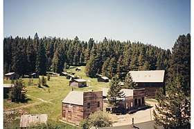 Garnet Ghost Town, Garnet Range | |
| Highest point | |
| Peak | Old Baldy Mountain |
| Elevation | 7,511 ft (2,289 m) |
| Coordinates | 46°42′38″N 112°52′17″W / 46.71056°N 112.87139°WCoordinates: 46°42′38″N 112°52′17″W / 46.71056°N 112.87139°W |
| Geography | |
 Garnet Range | |
| Country | United States |
| State | Montana |
The Garnet Range, highest point Old Baldy Mountain, elevation 7,511 feet (2,289 m),[1] is a mountain range northeast of Drummond, Montana in Powell County, Montana.
A popular historic site, Garnet Ghost Town, is in the Garnet Range. Situated on Bureau of Land Management (BLM) land, the ghost town is the remnant of a mining settlement that was inhabited from the late 1800s to the 1930s.[2] The town's population reached several thousand during its peak.[2] A visitor center and self-guided tours are available.[2]
Although heavily forested, no portion of the Garnet Range is part of the National Forest system. The BLM owns much of the range, including the 11,580-acre Wales Creek Wilderness Study Area.[3] The Wales Creek WSA is the last major unroaded drainage in the western Garnets, and features dense forests of lodgepole pine, spruce, douglas fir, larch, aspen, and subalpine fir.[4] Wales Creek WSA also hosts a thriving moose herd, goshawk nesting sites, a native cutthroat trout fishery, and four hot springs used in the past by miners and now by skiers and hunters.[4]
Another BLM Wilderness Study Area is in the eastern Garnets: the 11,380-acre Hoodoo Mountain WSA. This WSA is separated from unprotected BLM land in the Gallagher Creek drainage by a dirt road. Petrified wood is found along streams in the Gallagher Creek area.[4]
On the southern slope of the Garnets near the town of Drummond, the BLM's Rattler Gulch Area of Critical Environmental Concern protects 20 acres of exposed Madison Group limestone cliffs.[5] Parking is provided, as Rattler Gulch is a popular rock-climbing area.[6]
Grizzly bears have recently been confirmed inhabiting the Garnets.[7]
See also
Notes
- ↑ Recreational Map of Western Montana. Canon City, CO: Western GeoGraphics. 1990. ISBN 0-528-92551-2.
- 1 2 3 Montana Atlas & Gazetteer. Yarmouth, ME: DeLorme. 2004. p. 13. ISBN 0-89933-339-7.
- ↑ "National Landscape Conservation System – Wilderness Study Areas" (PDF). Archived from the original (PDF) on 22 February 2013. Retrieved 7 December 2011.
- 1 2 3 Cunningham, Bill (1990). Montana Wildlands. Helena, MT: American Geographic Publishing. pp. 43–44. ISBN 0-938314-93-9.
- ↑ Montana Atlas & Gazetteer. Yarmouth, ME: DeLorme. 2004. p. 5. ISBN 0-89933-339-7.
- ↑ rockclimbing.com. "Rattler Gulch". Archived from the original on 25 February 2008. Retrieved 14 December 2011.
- ↑ Chaney, Rob. "Radio collar confirms griz on Missoula fringe for 1st time". Missoulian. Retrieved 24 January 2013.
