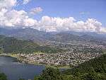
Gandaki Pradesh
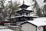
.JPG)
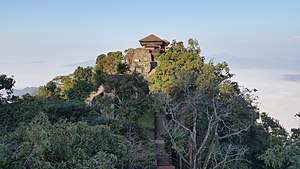
.jpg)

Gandaki Pradesh (Nepali: गण्डकी प्रदेश) is one of the seven federal provinces established by the current constitution of Nepal that was adopted on 20 September 2015.[1] Pokhara is the capital city. It borders the Tibet Autonomous Region of China to the north, Province No. 3 to the east, Karnali Pradesh to the west, and Province No. 5 and Uttar Pradesh of India to the south. The total area of the province is 21,504 km². According to the 2011 Nepal census, the population of the province was 2,403,757.[2]
Initially known as Province No. 4, the newly elected Provincial Assembly adopted Gandaki Pradesh as the permanent name for the province in July 2018.
History
The name of Gandaki Pradesh is based on River, Gandaki. All of the districts of Gandaki Pradesh are irrigated by one and one of the branches of Gandaki River. Gandaki Pradesh is formed by combining former two Zones of Nepal, those are Gandaki Zone and Dhaulagiri Zone, and Nawalpur region of former Nawalparasi District of Lumbini Zone. The name, Gandaki Pradesh is also related to Gandaki River Civilization.
Geography
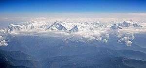
The province covers an area of 21,773 km2 which is about 14.66% of the total area of Nepal. The state is extends between 27°-20' N ~ 29°-20' N latitude and 82° 52' E ~ 85°-12' E longitude. In terms of terrain, the province is spread over the Himalayan, Hilly and Terai region of Nepal; 5,919 km2 (26.8%) of the area falls under the Himalayan region, 14,604 km2 (67.2%) of the area falls under the Hilly region and 1,310 km2 (6%) of the area falls under the Terai region.[3]
| Location | August
(°F) |
August
(°C) |
January
(°F) |
January
(°C) |
Annual
Precipitation (mm/in) |
|---|---|---|---|---|---|
| Pokhara | 74.8 | 23.8 | 50.4 | 10.2 | 2010.3/79.1 |
| Baglung | 72.1 | 22.3 | 47.5 | 8.6 | 1766.1/69.5 |
| Waling | 77.5 | 25.3 | 54.1 | 12.3 | 2089.7/82.3 |
| Besishahar | 72.3 | 22.4 | 47.5 | 8.6 | 1639.6/64.6 |
| Modi | 60.8 | 16 | 33.4 | 0.8 | 1094.7/43.1 |
Government and administration
The Governor acts as the head of the province while the Chief Minister is the head of the provincial government. The Chief Judge of the Pokhara High Court is the head of the judiciary.[5] The present Governor, Chief Minister and Chief Judge are Baburam Kunwar (governor), Prithvi Subba Gurung (chief minister) and Purushottam Bhandari.[6][7] The province has 60 provincial assembly constituencies and 18 federal House of Representative constituencies.[8]
Gandaki Pradesh has a unicameral legislature, like that of the other provinces in Nepal. The tenure of provincial assembly is of five years. The Provincial Assembly of Gandaki is temporarily housed at the Town Development Training Centre in Pokhara.[9]
Administrative subdivisions
Gandaki province is divided into 11 districts, which are listed below. A district is administrated by the head of the District Coordination Committee and the District Administration Officer. The districts are further dived to municipalities or rural municipalities. The municipalities include one metropolitan city and 26 municipalities. There are 58 rural municipalities in the province.[10]
Demographics
The province has a population of 2,403,016 which is 9.06% of the total population of Nepal. The population density is about 110 persons per square kilometre. The province has a population growth rate of -0.33%. The sex ratio is 89 males for 100 females, with a total of 948,028 males and 1,144,124 females recorded in 2011. The urban population of the region is 1,452,186 (60.5%) and the rural population is 943,652 (39.5%). About 50.1% of the population in the province are financially independent.[3]
| Rank | District | Pop. | Rank | District | Pop. | ||||
|---|---|---|---|---|---|---|---|---|---|
 Pokhara |
1 | Pokhara | Kaski | 414,141 | 11 | Putalibazar | Syangja | 44,876 |  Gaindakot |
| 2 | Vyas | Tanahun | 70,335 | 12 | Devchuli | Nawalpur | 42,603 | ||
| 3 | Kawasoti | Nawalpur | 62,421 | 13 | Kushma | Parbat | 39,600 | ||
| 4 | Gaindakot | Nawalpur | 58,836 | 14 | Besishahar | Lamgunj | 39,356 | ||
| 5 | Baglung | Baglung | 57,823 | 15 | Palungtar | Gorkha | 38,174 | ||
| 6 | Madhyabindu | Nawalpur | 54,140 | 16 | Galyang | Syangja | 36,967 | ||
| 7 | Waling | Syangja | 51,143 | 17 | Beni | Myagdi | 33,498 | ||
| 8 | Gorkha | Gorkha | 49,272 | 18 | Galkot | Baglung | 33,097 | ||
| 9 | Shuklagandaki | Tanahun | 48,456 | 19 | Jaimini | Baglung | 31,430 | ||
| 10 | Bhanu | Tanahun | 45,792 | 20 | Bhimad | Tanahun | 31,362 | ||
See also
References
- ↑ "Nepal Provinces". statoids.com. Retrieved 2016-03-21.
- ↑ "Gandaki Province in Nepal population". www.citypopulation.de. Retrieved 2018-06-04.
- 1 2 "Province Profile" (PDF). Government of Province No. 4.
- ↑ "Nepal Travel Weather Averages (Weatherbase)". Weatherbase. Retrieved 2018-04-28.
- ↑ "High Courts get their chief judges". Retrieved 2018-04-27.
- ↑ "Prithvi Subba Gurung appointed as Province 4 CM - The Himalayan Times". The Himalayan Times. 2018-02-12. Retrieved 2018-04-27.
- ↑ "President of Nepal administers oath to Chiefs of seven provinces | DD News". ddnews.gov.in. Retrieved 2018-04-27.
- ↑ "CDC creates 495 constituencies". The Himalayan Times. 2017-08-31. Retrieved 2018-04-27.
- ↑ "First Provincial Assembly meeting of province 4 begins". Retrieved 2018-04-27.
- ↑ "स्थानिय तह". 103.69.124.141. Retrieved 2018-04-27.
- ↑ http://parliament.gov.np/np/ncd.html
Places adjacent to Gandaki Pradesh | ||||||||||
|---|---|---|---|---|---|---|---|---|---|---|
| ||||||||||
