The Midlands
| The Midlands | |
|---|---|
 The East Midlands and West Midlands regions of England | |
| Sovereign state | United Kingdom |
| Country | England |
| Largest Cities |
1. Birmingham ≈2. Coventry ≈2. Leicester ≈2. Nottingham 5. Stoke-on-Trent |
| Principal 'cities' |
A
'Metro' cities
B Other large settlements
|
| Area | |
| • Total | 11,053 sq mi (28,627 km2) |
| Population (2011 census) | |
| • Total | 10,135,000 |
| • Density | 920/sq mi (350/km2) |
| • Urban | 8,079,000 |
| • Rural | 2,056,000 |
| Demonym(s) | Midlander |
| Time zone | UTC+0 (Greenwich Mean Time) |
| • Summer (DST) | UTC+1 (British Summer Time) |
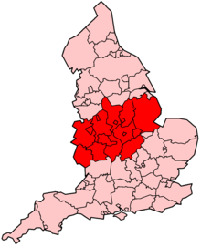
The Midlands is a cultural and geographic area roughly spanning central England that broadly corresponds to the early medieval Kingdom of Mercia. It borders South East England, South West England, North West England, Yorkshire and Humber, East of England and Wales. Its largest city is Birmingham, and the region was important in the Industrial Revolution of the 18th and 19th centuries. In modern terms the Midlands comprises the English statistical regions of the East Midlands and West Midlands. Almost all administrative functions for the English regions were abolished in 2012, although they remain constituencies of the European Parliament, and are proposed under the Sixth Periodic Review of Westminster constituencies to replace counties as the subdivisions of England used to draw parliamentary constituencies.
Extent
Although there is no precise definition, the Midlands, if defined as being made up of the regions of East Midlands and West Midlands, includes the counties of Derbyshire, Herefordshire, Leicestershire, Lincolnshire (not including its boroughs of North Lincolnshire and North East Lincolnshire), Northamptonshire, Nottinghamshire, Rutland, Shropshire, Staffordshire, Warwickshire, Worcestershire and the West Midlands metropolitan boroughs. If not following the official regional boundaries, the Midlands might be said to also include Peterborough (historically part of Northamptonshire), and the aforementioned boroughs of Lincolnshire. Additionally, there exists an informal region known as the South Midlands which could be defined to include Bedfordshire, Buckinghamshire, Oxfordshire and Gloucestershire.
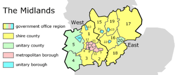
With more restricted boundaries than the traditional area known as the Midlands, two modern statistical regions together represent the latter: West Midlands and East Midlands. These are also constituencies of the European Parliament.
The West Midlands region comprises:
- the shire counties of Staffordshire (1), Warwickshire (2) and Worcestershire (3),
- the unitary counties of Herefordshire (4) and Shropshire (5),
- the metropolitan boroughs of Birmingham (6), Coventry (7), Dudley (8), Sandwell (9), Solihull (10), Walsall (11) and Wolverhampton (12), and
- the city of Stoke-on-Trent (13) and the borough of Telford and Wrekin (14); (unitary authorities).
The East Midlands region comprises:
- the shire counties of Derbyshire (15), Leicestershire (16), Lincolnshire (17), Northamptonshire (18) and Nottinghamshire (19),
- the unitary county of Rutland (20), and
- the cities of Derby (21), Leicester (22) and Nottingham (23); (unitary authorities).
The two regions have a combined estimated 2014 population of 10,350,000 (10,135,000; 2011 census), and an area of 11,053 sq mi (28,631 km²).
The largest Midlands conurbation, which includes the cities of Birmingham and Wolverhampton, is roughly covered by the metropolitan county of the West Midlands (which also includes the city of Coventry); with the related City Region extending into neighbouring areas of Shropshire, Staffordshire, Warwickshire and Worcestershire.
Various parts of the Midlands, particularly Warwickshire and Leicestershire, are on occasion referred to as the Heart of England, especially in tourist literature given that the geographic centre of England is generally considered to lie within this arc.
The various areas of the Midlands have their own distinctive character, giving rise to a high number of local history and industrial heritage groups. Nottingham played a notable part in the English Civil War, which is commemorated in a number of place names (Parliament Terrace, Parliament Street, Standard Hill). Areas such as Derbyshire's Amber Valley and Erewash combine attractive countryside with industrial heritage and are home to historic canals and sites associated with the mining industry. The Black Country, broadly the boroughs of Dudley, Sandwell, Wolverhampton and Walsall, played an important part in the Industrial Revolution.
"Midlands Engine" enterprise area
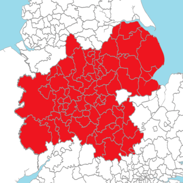
The Midlands Engine for Growth is a government initiative established in 2017 that seeks to make the Midlands an engine of growth for the UK economy. It is backed by businesses, local authorities, and 11 Local Enterprise Partnerships. Its boundaries are wider than those of the statistical regions of the West and East Midlands, in that it incorporates the whole of Lincolnshire, including the districts of North Lincolnshire and North East Lincolnshire (which, although part of the ceremonial county of Lincolnshire, are in Yorkshire and the Humber region); Bedfordshire (East of England region); Aylesbury Vale and Milton Keynes districts in Buckinghamshire, and Cherwell district in Oxfordshire (South East England region). It does not, however, include Rutland (East Midlands region), which is part of the Greater Cambridge Greater Peterborough Enterprise Partnership.[1]
Geography
The Midlands is predominantly low-lying and flat, although isolated hills such as Turners Hill have extensive views. Upland areas lie in the west and north of the region with the Shropshire Hills to the west, close to the Welsh border, and the Peak District area of the southern Pennines in the north of the region. The Shropshire Hills reach heights of over 500 m, including the Long Mynd, Clee Hills and Stiperstones ridge. Wenlock Edge, running through the middle of the Shropshire Hills Area of Outstanding Natural Beauty (AONB), is a long, low ridge, which extends for over 15 miles (24 km).[2] The Peak District reaches heights of between 300 m and 600 m; Kinder Scout is the highest point at 636 m.[3] Further south, the Welsh border reaches over 700 m high, at Black Mountain, which is thus the highest point in Herefordshire.
The Malverns are formed of some of the oldest rock in England (around 680 million years old) and extend for some 13 km (8 miles) through two West Midlands counties (Worcestershire and Herefordshire) as well as northern Gloucestershire in the southwest. The highest point of the hills is the Worcestershire Beacon at 425 m (1,394 ft) above sea level (OS Grid reference SO768452).[4][5]
Other areas of lower hills, in the range 200 m - 300 m, include Charnwood Forest in Leicestershire, Cannock Chase in Staffordshire, and the Lincolnshire Wolds (100 m - 200 m); the latter having some prominence despite their modest altitude given their location in typically low-lying Lincolnshire near to the east coast.
The Cotswolds – designated an AONB in 1966.[6] – extend for over 90 miles (140 km) through six counties (Oxfordshire, Gloucestershire, Wiltshire, Somerset, Warwickshire, and Worcestershire), but centred on Gloucestershire. They reach a highest point of 330 m at Cleeve Hill.
Climate
The Midlands has a temperate maritime climate, with cold, cloudy, wet winters and comfortable, mostly dry, mostly sunny summers.[7] The temperature usually ranges from −0.4 °C (31.3 °F) during winter nights to 24.1 °C (75.4 °F) during summer days. Due to its geographical location, which is furthest away from the coast than anywhere else in England, it typically receives mostly light winds, with warm days and cold nights. Sometimes the Midlands can have very cold nights such as a minimum of −18.7 °C (−1.7 °F) in Pershore on 20 December 2010. The previous day had a maximum of only −8.2 °C (17.2 °F), also in Pershore. Hot days are also possible, such as a maximum of 34 °C (93 °F) in Pershore on 19 July 2006. There can also be very mild winters nights, such as in Bidford-on-Avon when the temperature at 6 pm was as high as 15.2 °C (59.4 °F) on 9 January 2015. At 8 am the following morning the temperature was still at 13 °C (55 °F).[8][9][10]
| Climate data for Midlands | |||||||||||||
|---|---|---|---|---|---|---|---|---|---|---|---|---|---|
| Month | Jan | Feb | Mar | Apr | May | Jun | Jul | Aug | Sep | Oct | Nov | Dec | Year |
| Average high °C (°F) | 6.7 (44.1) |
7 (45) |
9.7 (49.5) |
12.5 (54.5) |
15.9 (60.6) |
18.8 (65.8) |
21.1 (70) |
20.8 (69.4) |
17.8 (64) |
13.7 (56.7) |
9.6 (49.3) |
6.9 (44.4) |
13.4 (56.1) |
| Average low °C (°F) | 1 (34) |
0.8 (33.4) |
2.4 (36.3) |
3.7 (38.7) |
6.5 (43.7) |
9.4 (48.9) |
11.5 (52.7) |
11.3 (52.3) |
9.3 (48.7) |
6.5 (43.7) |
3.5 (38.3) |
1.3 (34.3) |
5.6 (42.1) |
| Average rainfall mm (inches) | 74 (2.91) |
54 (2.13) |
58.8 (2.315) |
59.1 (2.327) |
58.5 (2.303) |
62.3 (2.453) |
60.8 (2.394) |
66.9 (2.634) |
66.2 (2.606) |
82 (3.23) |
77.1 (3.035) |
78.7 (3.098) |
798.4 (31.435) |
| Average rainy days (≥ 1 mm) | 12.9 | 10.2 | 11.5 | 10.6 | 10.2 | 9.7 | 9.4 | 10 | 9.7 | 12.2 | 12.5 | 12.4 | 131.3 |
| Mean monthly sunshine hours | 52.1 | 71.4 | 104.8 | 147 | 183.2 | 174.7 | 189.6 | 177.6 | 132.2 | 99.4 | 61.2 | 45 | 1,438.2 |
| Source: Met Office [11] | |||||||||||||
See also
- East Midlands topics
- West Midlands topics
- Regions of England
- Northern England
- Southern England
- Subdivisions of England
References
- ↑ "The Midlands Engine". The Local Enterprise Partnership for Derby, Derbyshire, Nottingham and Nottinghamshire. Retrieved 28 July 2017.
- ↑ "Some Shropshire Hills…". Shropshire Hills Area of Outstanding Natural Beauty. Retrieved 23 June 2016.
- ↑ "Peak District National Park Facts & Figures". Wheeldon trees Farm. Retrieved 23 June 2016.
- ↑ "The Malvern Hills". Abberley and Malvern Hills Geopark. Archived from the original on 21 July 2011. Retrieved 23 June 2016.
- ↑ "Malverns Complex". Herefordshire and Worcestershire Earth Heritage Trust. Retrieved 23 June 2016.
- ↑ "The Cotswolds". The Cotswolds. Retrieved 23 June 2016.
- ↑ Calculated using data from WorldClim.org. Hijmans, R.J.; Cameron, S.E.; Parra, J.L.; Jones, P.G.; Jarvis, A. (2005). "Very high resolution interpolated climate surfaces for global land areas. International Journal of Climatology". 25: 1965–1978.
- ↑ Snow and low temps 2010 http://www.metoffice.gov.uk/climate/uk/interesting/dec2010
- ↑ December 2010 http://www.metoffice.gov.uk/climate/uk/summaries/2010/december
- ↑ Record heat July 2006 http://www.metoffice.gov.uk/climate/uk/interesting/july2006/
- ↑ Office, Met. "Ragley Hall climate". www.metoffice.gov.uk.

Districts of the West Midlands Region | ||
|---|---|---|
| Herefordshire | 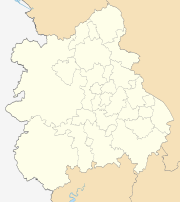 | |
| Shropshire | ||
| Staffordshire | ||
| Warwickshire | ||
| West Midlands | ||
| Worcestershire | ||
| Authority control |
|---|