Lincolnshire Wolds
| Lincolnshire Wolds | |
| Area of Outstanding Natural Beauty | |
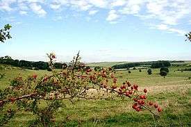  The Lincolnshire Wolds (top), location within Lincolnshire (bottom) | |
| Country | England |
|---|---|
| County | Lincolnshire |
| Location | Midlands |
| - coordinates | 53°21′0″N 0°6′0″W / 53.35000°N 0.10000°WCoordinates: 53°21′0″N 0°6′0″W / 53.35000°N 0.10000°W |
| Highest point | |
| - location | Wolds Top |
| - elevation | 168 m (551 ft) |
| Area | 560 km2 (216 sq mi) |
| Geology | chalk, clay, limestone, sandstone |
| Plants | hawthorn, gentian, kidney vetch |
| Animals | Kestrel, meadow pipit, short-eared owl, woodcock |
| Founded | 1973 |
| Management | Lincolnshire Wolds Countryside Service |
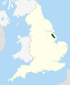 Location of the Lincolnshire Wolds AONB in the UK | |
The Lincolnshire Wolds is a range of hills in the county of Lincolnshire, England. It is a designated Area of Outstanding Natural Beauty (AONB), and the highest area of land in eastern England between Yorkshire and Kent. They run roughly parallel with the North Sea coast, from the River Humber in the north-west to the edge of the Lincolnshire Fens in the south-east.[1][2]
Geography
The Wolds comprise a series of low hills and steep valleys underlain by calcareous (chalk and limestone) and sandstone rock, laid down in the Cretaceous period. The characteristic open valleys of the Wolds were created during the last glacial period through the action of glaciation and meltwater.
Geologically, the Lincolnshire Wolds is a continuation of the Yorkshire Wolds which runs through the East Riding of Yorkshire; the point at which the ranges of hill crosses the Humber is known as the Humber Gap.[2]

The Lincolnshire Wolds can be divided into four distinct areas:[2]
- the main area of chalk hills in the north,
- the north west scarp,
- an area of ridges and valleys in the south west,
- the claylands in the south east.
The Red Hill nature reserve near the village of Goulceby is notable for the unusual red colour of its soil and underlying chalk.
Wolds Top is the highest point in the whole of Lincolnshire and is marked by a trig point just north of the village of Normanby le Wold, at approximately 551 feet (168 metres) above sea level (TF121964).[1]
Other hills include:
- Castcliffe Hill - TF301735 - 456 feet (139 m)
- Gaumer Hill - TF289778 - 423 feet (129 m)
- Meagram Top - TF392789 - 190 feet (58 m)
- Warden Hill - TF347737 - 371 feet (113 m)
- Tetford Hill - TF326761 - 466 feet (142 m)
- Hoe Hill - TF308731 - 417 feet (127 m)
The Wolds provide views across the flat fens and salt marshes of Lindsey and Holland: it is possible, from various points on the Wolds, to see all of the larger structures in the north and east of the county: the Belmont mast, Boston Stump, Grimsby Dock Tower, the Humber Bridge, Lincoln Cathedral, St James' Church in Louth (known locally as the 'Cathedral of the Wolds', though it holds only parish church status), the radar station near Normanby, Tattershall Castle and the wind turbines on the coast near Mablethorpe.
Waterways
| Name | Length | Source | Source Elevation (m) | Mouth | Mouth Elevation (m) | Notes |
|---|---|---|---|---|---|---|
| River Bain | Ludford | 130 | River Witham, Dogdyke | 2 | ||
| Great Eau | North Sea, Saltfleet Haven | |||||
| River Lud | North Sea, North Coates | Also known as the Louth Navigation due to its canalisation. | ||||
| River Lymn | Belchford | 91 | North Sea, Gibraltar Point | 0 | ||
| River Rase | Tealby | 118 | River Ancholme, Bishopbridge | 6 | ||
| River Waring | Belchford | 100 | River Bain, Horncastle | 28 |
AONB
The Lincolnshire Wolds were designated an Area of Outstanding Natural Beauty (AONB) in 1973, and are managed as such by the Lincolnshire Wolds Countryside Service.[3][4]
The Wolds Area of Outstanding Natural Beauty covers 560 square kilometres, while the Countryside Service recognise a wider Lincolnshire Wolds Character/Natural Area which incorporates the AONB and the neighbouring areas of the (geographical) Wolds to the north and south, which are not covered by the AONB.[2]
The Wolds AONB cuts across the council boundaries of Lincolnshire County Council, East Lindsey District Council, West Lindsey District Council and North East Lincolnshire Council.[1][2]
The boundaries of the AONB are marked by tourist signs incorporating stylized hills and trees, placed on roads leading into and out of the Wolds. The placing of these signs has not been uncontroversial, with some residents unhappy that they outline only the Wolds AONB and not the cultural/geographical area as a whole.
People and places
The Wolds are sparsely populated and have a rural character. They are 'ringed' by several small market towns that lie around their edge:[1]
- Alford
- Horncastle, billed on tourist signs as the "gateway to the Wolds", lies just outside the south end of the AONB
- Louth, "the capital of the Wolds"
- Market Rasen
- Caistor
- Spilsby
Many of the placenames in the Wolds indicate a strong Viking influence in the area's history. There is also an abundance of mediaeval 'lost villages' – settlements abandoned due to changes in land use, soil exhaustion and disease.
Several notable roads and paths run over the Wolds. Caistor High Street, the path of a Roman road and now the route of the B1225, runs from Caistor to Baumber near Horncastle. The ancient Bluestone Heath Road follows the course of an ancient drove road from west to east across the Wolds, and several "A" roads also run through the AONB.[1]
The Wolds are now promoted as a tourist destination: the area's connection with Tennyson (who was born in Somersby) is being exploited,[5][6] and farmers are being encouraged to diversify into the tourism industry. The roads of the Wolds are particularly popular with motorcyclists, and the area is home to Cadwell Park, one of the UK's top race circuits.[7][8]
The area is also popular with hikers: the Viking Way long-distance footpath runs from Barton-upon-Humber in North Lincolnshire across the Lincolnshire Wolds and into Rutland,[9][10] and there is a Youth Hostel in the middle of the Wolds at Woody's Top near the village of Tetford.[11][12]
References
- 1 2 3 4 5 Ordnance Survey maps:
Lincolnshire Wolds North (Map) (A1 ed.). 1:25000. Explorer. Ordnance survey of Great Britain. 3 April 2006. § 282. ISBN 978-0319238233.
Lincolnshire Wolds South (Map) (A1 ed.). 1:25000. Explorer. Ordnance survey of Great Britain. 3 April 2006. § 273. ISBN 978-0319238219. - 1 2 3 4 5 "NCA Profile: 43 Lincolnshire Wolds (NE440)". Publications and products. Natural England. Retrieved 13 October 2013.
- ↑ "Lincolnshire wolds". Lincolnshire wolds countryside service. Retrieved 13 October 2013.
- ↑ "AONB facts and figures". Natural England. Retrieved 13 October 2013.
- ↑ "The birthplace of Tennyson". St Margaret's Somersby PCC. Retrieved 13 October 2013.
- ↑ "Birth Place of Lord Alfred Tennyson, Somersby, Lincolnshire". Explore Lincolnshire. Retrieved 13 October 2013.
- ↑ "Cadwell park race circuit". Retrieved 13 October 2013.
- ↑ "Cadwell Park". British superbikes. Retrieved 13 October 2013.
A real mecca for bike fans, Cadwell Park hosts the biggest round of the British Superbike Championship, with thousands of spectators travelling to the circuit fondly nicknamed the "Mini-Nurburgring" every August Bank Holiday weekend. Cadwell Park is probably most famous for "the Mountain", where bikes frequently get airbourne, and it's the striking mix of twists, cambers and gradients that have led to the circuit's burgeoning popularity over the years.
- ↑ "The Viking way". Lincolnshire county council. Retrieved 13 October 2013.
- ↑ "The Viking way". Long Distance Walkers Association. Retrieved 13 October 2013.
- ↑ "Woody's Top". Youth Hostel Association. Retrieved 13 October 2013.
- ↑ "Woody's Top youth hostel". Visit Lincolnshire.
- "Landscape character". Lincolnshire Wolds Area of Outstanding Natural Beauty. Lincolnshire Wolds Countryside Service. Retrieved 12 October 2013.
- "43 Lincolnshire Wolds". National Character Areas. Natural England. Retrieved 12 October 2013.
- "The Lincolnshire Wolds". Areas of outstanding natural beauty. Natural England. Retrieved 12 October 2013.
- "The Lincolnshire Wolds AONB". Lincolnshire landscapes. Greater Lincolnshire nature partnership. Retrieved 12 October 2013.
- Rawding, C. (2001). The Lincolnshire Wolds in the nineteenth century. Lincoln: History of Lincolnshire Committee,.
- The Lincolnshire Wolds Landscape. Landscape Character Assessment. Natural England Publications, Communisis Print Management, Balliol Business Park West, Benton Lane, Newcastle upon Tyne, NE12 8EW: The Countryside Commission. 1993. Precursor to the Natural England designation
- Thorold., Henry; Yates, Jack (1968). Lincolnshire. The Shell Guide. London: Faber & Faber.
- "Spilsby Sandstone". Lexicon of Named Rock Units. British geological survey. Retrieved 12 October 2013.
- "Lincolnshire Limestone". Lexicon of Named Rock Units. British geological survey. Retrieved 12 October 2013.
External links
| Wikimedia Commons has media related to Lincolnshire Wolds. |
| East of England |  | |
|---|---|---|
| East Midlands | ||
| North East | ||
| North West | ||
| South East | ||
| South West | ||
| West Midlands | ||
| Yorkshire and Humber | ||
1 Now part of South Downs National Park • 2 Now part of New Forest National Park • 3 Partly in Wales | ||