Lehigh, Kansas
| Lehigh, Kansas | |
|---|---|
| City | |
 Skyline of Lehigh (2010) | |
 Location within Marion County and Kansas | |
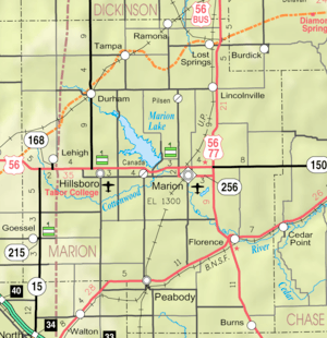 KDOT map of Marion County (legend) | |
| Coordinates: 38°22′24″N 97°18′10″W / 38.37333°N 97.30278°WCoordinates: 38°22′24″N 97°18′10″W / 38.37333°N 97.30278°W[1] | |
| Country | United States |
| State | Kansas |
| County | Marion |
| Township | Lehigh |
| Platted | 1881 |
| Incorporated | 1901 |
| Government | |
| • Type | Mayor–Council |
| • Mayor | David Terrell [2] |
| • City Clerk | Donna Terrell [2] |
| Area[3] | |
| • Total | 0.30 sq mi (0.8 km2) |
| • Land | 0.30 sq mi (0.8 km2) |
| • Water | 0 sq mi (0 km2) |
| Elevation[1] | 1,532 ft (467 m) |
| Population (2010)[4] | |
| • Total | 175 |
| • Estimate (2016)[5] | 167 |
| • Density | 580/sq mi (230/km2) |
| Time zone | UTC-6 (CST) |
| • Summer (DST) | UTC-5 (CDT) |
| ZIP code | 67073 |
| Area code | 620 |
| FIPS code | 20-39225 [1] |
| GNIS ID | 0477226 [1] |
Lehigh is a city in Marion County, Kansas, United States.[1] As of the 2010 census, the city population was 175.[6]
History

Early history
For many millennia, the Great Plains of North America was inhabited by nomadic Native Americans. From the 16th century to 18th century, the Kingdom of France claimed ownership of large parts of North America. In 1762, after the French and Indian War, France secretly ceded New France to Spain, per the Treaty of Fontainebleau.
19th century
In 1802, Spain returned most of the land to France. In 1803, most of the land for modern day Kansas was acquired by the United States from France as part of the 828,000 square mile Louisiana Purchase for 2.83 cents per acre.
In 1854, the Kansas Territory was organized, then in 1861 Kansas became the 34th U.S. state. In 1855, Marion County was established within the Kansas Territory, which included the land for modern day Lehigh.[7]
The source of the Lehigh name was not well documented. One of the rumors is the city being slightly higher altitude which was "lay high" above the prairie, the other rumor that it was named by representatives of Lehigh County, Pennsylvania who came to Kansas and considered settling the area in the 1870s or 1880s.[8]
Four and one half miles north of Lehigh is the junction of the old Santa Fe Trail and Chisolm Trail, which is near the site of the municipal water well for the city. The Santa Fe Trail was active across Marion County from 1821 to 1866,[9] and the Chisholm Trail was active from 1867 to 1871.[10]
As early as 1875, city leaders of Marion held a meeting to consider a branch railroad from Florence. In 1878, Atchison, Topeka and Santa Fe Railway and parties from Marion County and McPherson County chartered the Marion and McPherson Railway Company.[11] In 1879, a branch line was built from Florence to McPherson, in 1880 it was extended to Lyons, in 1881 it was extended to Ellinwood.[12] The line was leased and operated by the Atchison, Topeka and Santa Fe Railway. The line from Florence to Marion, was abandoned in 1968.[13] In 1992, the line from Marion to McPherson was sold to Central Kansas Railway. In 1993, after heavy flood damage, the line from Marion through Lehigh to McPherson was abandoned and removed. The original branch line connected Florence, Marion, Canada, Hillsboro, Lehigh, Canton, Galva, McPherson, Conway, Windom, Little River, Mitchell, Lyons, Chase, Ellinwood. The 1879 depot from Lehigh was moved to Walton, Kansas.[14][15]
A post office was established at Lehigh on April 23, 1880.[16]
20th century
Lehigh was incorporated in 1901 and at the time of the 1910 census had a population of 385. At one time it boasted a bank, several mercantile businesses, and a German weekly Mennonite newspaper, Das Echo, started in 1897.[18]
The National Old Trails Road, also known as the Ocean-to-Ocean Highway, was established in 1912, and was routed through Lehigh, Hillsboro, Marion, Lost Springs.
Geography
Lehigh is located at 38°22′24″N 97°18′10″W / 38.37333°N 97.30278°W (38.373447, -97.302907).[1] According to the United States Census Bureau, the city has a total area of 0.30 square miles (0.78 km2), all of it land.[3] The county line is 3.5 miles west of Lehigh. The North and South Cottonwood River start a few miles northwest of Lehigh.
Area Events
- Lehigh Antique Tractor & Engine Show, every Memorial Day.[19]
Area attractions
- Santa Fe Trail
- Santa Fe Trail / Chisholm Trail Marker, approximately 3.5 miles west and next to U.S. Route 56 highway.
- Santa Fe Trail Markers, numerous markers in the area.
- Santa Fe Trail Self-Guided Auto Tour.
- Marion Reservoir, approximately 10 miles east of Lehigh.
Demographics
| Historical population | |||
|---|---|---|---|
| Census | Pop. | %± | |
| 1910 | 385 | — | |
| 1920 | 570 | 48.1% | |
| 1930 | 315 | −44.7% | |
| 1940 | 296 | −6.0% | |
| 1950 | 240 | −18.9% | |
| 1960 | 178 | −25.8% | |
| 1970 | 168 | −5.6% | |
| 1980 | 189 | 12.5% | |
| 1990 | 180 | −4.8% | |
| 2000 | 215 | 19.4% | |
| 2010 | 175 | −18.6% | |
| Est. 2016 | 167 | [5] | −4.6% |
| U.S. Decennial Census | |||
2010 census
As of the census[4] of 2010, there were 175 people, 70 households, and 49 families residing in the city. The population density was 583.3 inhabitants per square mile (225.2/km2). There were 84 housing units at an average density of 280.0 per square mile (108.1/km2). The racial makeup of the city was 96.6% White, 2.9% from other races, and 0.6% from two or more races. Hispanic or Latino of any race were 4.0% of the population.
There were 70 households of which 32.9% had children under the age of 18 living with them, 54.3% were married couples living together, 7.1% had a female householder with no husband present, 8.6% had a male householder with no wife present, and 30.0% were non-families. 27.1% of all households were made up of individuals and 12.9% had someone living alone who was 65 years of age or older. The average household size was 2.50 and the average family size was 3.02.
The median age in the city was 32.8 years. 29.7% of residents were under the age of 18; 8.7% were between the ages of 18 and 24; 24.6% were from 25 to 44; 23.4% were from 45 to 64; and 13.7% were 65 years of age or older. The gender makeup of the city was 50.9% male and 49.1% female.
2000 census
As of the census[20] of 2000, there were 215 people, 77 households, and 62 families residing in the city. The population density was 714.3 people per square mile (276.7/km²). There were 83 housing units at an average density of 275.7 per square mile (106.8/km²). The racial makeup of the city was 93.95% White, 4.65% Native American, and 1.40% from two or more races. Hispanic or Latino of any race were 1.40% of the population.
There were 77 households out of which 37.7% had children under the age of 18 living with them, 75.3% were married couples living together, 2.6% had a female householder with no husband present, and 18.2% were non-families. 18.2% of all households were made up of individuals and 6.5% had someone living alone who was 65 years of age or older. The average household size was 2.79 and the average family size was 3.14.
In the city, the population was spread out with 31.6% under the age of 18, 4.2% from 18 to 24, 27.0% from 25 to 44, 20.0% from 45 to 64, and 17.2% who were 65 years of age or older. The median age was 36 years. For every 100 females, there were 97.2 males. For every 100 females age 18 and over, there were 90.9 males.
As of 2000 the median income for a household in the city was $38,958, and the median income for a family was $41,875. Males had a median income of $35,000 versus $20,714 for females. The per capita income for the city was $14,554. About 6.8% of families and 8.6% of the population were below the poverty line, including 19.0% of those under the age of eighteen and none of those sixty five or over.
Government

Lehigh has a government consisting of a Mayor and Five City Council. The council meets the 2nd Monday of each month at 7:30PM.[2]
- City Hall, 110 E Main St.
- U.S. Post Office, 112 W Main St.
Education
Primary and secondary education
Lehigh is a part of USD 410 Hillsboro.[21][22] The high school is a member of T.E.E.N., a shared video teaching network between five area high schools.[23] All students attend schools in Hillsboro.
- Hillsboro High School, located in Hillsboro.
- Hillsboro Middle School, located in Hillsboro.
- Hillsboro Elementary School, located in Hillsboro.
Lehigh Rural High School was closed after the spring graduation in 1966. The Lehigh High School mascot was Lehigh Eagles.[24]
Media
- Hillsboro Star-Journal, local newspaper from Hillsboro.
- Hillsboro Free Press, county newspaper for Marion County.
- The Newton Kansan, regional newspaper from Newton.
- The Salina Journal, regional newspaper from Salina.
Radio
Lehigh is served by numerous radio stations of the Wichita-Hutchinson listening market area,[25] and satellite radio. See Media in Wichita, Kansas.
Television
Lehigh is served by over-the-air ATSC digital TV of the Wichita-Hutchinson viewing market area,[26] cable TV, and satellite TV. See Media in Wichita, Kansas.
Infrastructure
Transportation
U.S. Route 56 highway is 0.5 miles (0.80 km) south of the city.
Utilities
- Internet
- TV
- Satellite is provided by DirecTV, Dish Network.
- Terrestrial is provided by regional digital TV stations.
- Electricity
- Rural is provided by Flint Hills RECA.
- Water
- City is provided by City of Lehigh.
- Rural is provided by Marion County RWD #4.
Gallery
- Historic Images of Lehigh, Special Photo Collections at Wichita State University Library.
 Cooperative Grain and Supply (2010)
 Old grain elevator (2010)
 Greeting Sign at corner of Main St and State Highway 168 (2010)
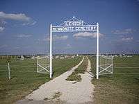 Lehigh Mennonite Cemetery, 1/2 mile south of Lehigh (2010)
See also
Further reading
References
- 1 2 3 4 5 6 Geographic Names Information System (GNIS) details for Lehigh, Kansas; United States Geological Survey (USGS); October 13, 1978.
- 1 2 3 Lehigh - Directory of Public Officials
- 1 2 "US Gazetteer files 2010". United States Census Bureau. Archived from the original on 2012-07-14. Retrieved 2012-07-06.
- 1 2 "American FactFinder". United States Census Bureau. Retrieved 2012-07-06.
- 1 2 "Population and Housing Unit Estimates". Retrieved June 9, 2017.
- ↑ "2010 City Population and Housing Occupancy Status". U.S. Census Bureau. Archived from the original on July 21, 2011. Retrieved March 6, 2011.
- ↑ The History of Marion County and Courthouse
- ↑ Marion County Kansas - Past and Present; Sondra Van Meter; 1972.
- ↑ History of the Cottonwood Crossing Chapter, Santa Fe Trail Association.
- ↑ Route of the Chisholm cattle trail in Kansas; Kansas Historical Society, 1960s.
- ↑ Marion County Kansas : Past and Present; Sondra Van Meter; MB Publishing House; LCCN 72-92041; 344 pages; 1972.
- ↑ Fourth Annual Report of the Board of Railroad Commissioners for the Year Ending December 1, 1886 in State of Kansas; Kansas Publishing House; 1886.
- ↑ Railway Abandonment 1968
- ↑ Photo of 1879 Lehigh depot.
- ↑ End of line is new beginning for Lehigh depot; The Wichita Eagle; September 6, 2017.
- ↑ "Kansas Post Offices, 1828-1961 (archived)". Kansas Historical Society. Archived from the original on 9 October 2013. Retrieved 14 June 2014.
- ↑ Blackmar, Frank Wilson (1912). Kansas: A Cyclopedia of State History, Volume 2. Standard Publishing Company. p. 137.
- ↑ Krahn, Cornelius (1956). "Global Anabaptist Mennonite Encyclopedia Online". Global Anabaptist Mennonite Encyclopedia Online.
- ↑ Lehigh Antique Tractor & Engine Show
- ↑ "American FactFinder". United States Census Bureau. Retrieved 2008-01-31.
- ↑ USD 410
- ↑ Kansas School District Boundary Map Archived 2011-07-21 at the Wayback Machine.
- ↑ T.E.E.N. video teaching network
- ↑ "Wilsey Beats Ada In Finals", The Salina Journal, 5 March 1961, p.17.
- ↑ Wichita-Hutchinson Radio market.
- ↑ Wichita-Hutchinson TV market.
External links
| Wikimedia Commons has media related to Lehigh, Kansas. |
- City
- Schools
- USD 410, school district for Hillsboro, Lehigh, Durham, nearby rural areas of Marion County
- USD 410 School District Boundary Map, KDOT
- Historic
- Marion County cemetery list, archive of KsGenWeb
- Marion County history bibliography, Marion County school bibliography, Kansas Historical Society
- Maps
- Lehigh City Map, KDOT
- Topo Map of Lehigh / Goessel area, USGS
- Marion County Maps: Current, Historic, KDOT
Municipalities and communities of Marion County, Kansas, United States | ||
|---|---|---|
| Cities | 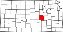 | |
| Unincorporated communities | ||
| Ghost towns | ||
| Townships | ||
| Footnotes | ‡This populated place also has portions in an adjacent county or counties | |