Menno Township, Marion County, Kansas
| Menno Township Marion County, Kansas | |
|---|---|
| Township | |
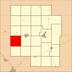 Location within Marion County | |
 Menno Township Marion County, Kansas Location within the state of Kansas | |
| Coordinates: 38°18′50″N 097°18′34″W / 38.31389°N 97.30944°WCoordinates: 38°18′50″N 097°18′34″W / 38.31389°N 97.30944°W | |
| Country | United States |
| State | Kansas |
| County | Marion |
| Area | |
| • Total | 36 sq mi (90 km2) |
| Dimensions | |
| • Length | 6.0 mi (9.7 km) |
| • Width | 6.0 mi (9.7 km) |
| Elevation | 1,476 ft (450 m) |
| Population (2010)[1] | |
| • Total | 330 |
| • Density | 9.2/sq mi (3.5/km2) |
| Time zone | UTC−06:00 (CST) |
| • Summer (DST) | UTC−05:00 (CDT) |
| Area code | 620 |
| FIPS code | 20-45800 [2] |
| GNIS feature ID | 477340 [3] |
| Website | County Website |
Menno Township is a township in Marion County, Kansas, United States. As of the 2010 census, the township population was 330.[1]
Geography
Menno Township covers an area of 36 square miles (93.2 km2).
Cities and towns
The township contains the following settlements:
- No cities or unincorporated communities.
Cemeteries
The township contains the following cemeteries:
- Alexanderwohl Mennonite Church Cemetery, located in Section 33 T20S R1E.[4]
- Gnadenfeld Community Cemetery (Schroeder Cemetery), located in Section 16 T20S R1E.[4]
- Lutheran Church Cemetery (Early), located in Section 11 T20S R1E.[4]
- Richert Cemetery, located in Section 22 T20S R1E.[4]
- Springfeld / Springfield K.M.B. Cemetery, located in Section 8 T20S R1E.[4]
- Steinbach Community Cemetery, located in Section 14 T20S R1E.[4]
- Wedel Cemetery (a.k.a. Blumenfeld Cemetery), located in Section 31 T20S R1E.[4]
- Wiebe Cemetery P.A. (a.k.a. North Springfield Cemetery), located in Section 7 T20S R1E.[4]
- Schroeder / Hochfeld Cemetery, located in Section 20 T20S R1E.[4]
- Blumfeld Cemetery (a.k.a. Wedel Cemetery), located in Section 31 T20S R1E.[4]
- Duerksen Cemetery, located in Section 14 T20S R1E.[4]
- John Banman Cemetery, located in Section 19 T20S R1E.[4]
- Heinrich Franzen Cemetery, located in Section 17 T20S R1E.[4]
- Andrew Schmidt Cemetery, located in Section 19 T20S R1E.[4]
- Peter Schmidt Cemetery, located in Section 29 T20S R1E.[4]
- Peter Unrau Cemetery, located in Section 29 T20S R1E.[4]
Transportation
Further reading
References
- 1 2 "2010 Total Population - Township of Menno". U.S. Census Bureau. Retrieved June 17, 2013.
- ↑ "American FactFinder". United States Census Bureau. Retrieved 2011-05-14.
- ↑ U.S. Geological Survey Geographic Names Information System: Township of Menno
- 1 2 3 4 5 6 7 8 9 10 11 12 13 14 15 16 Marion County Cemetery List. Archived 2013-05-09 at the Wayback Machine.
- ↑ Marion County Highway Map; KSDOT.
External links
- Marion County Website
- City-Data.com
- Marion County Maps: Current, Historic, KDOT
Places adjacent to Menno Township, Marion County, Kansas | |
|---|---|
Municipalities and communities of Marion County, Kansas, United States | ||
|---|---|---|
| Cities | 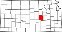 | |
| Unincorporated communities | ||
| Ghost towns | ||
| Townships | ||
| Footnotes | ‡This populated place also has portions in an adjacent county or counties | |
This article is issued from
Wikipedia.
The text is licensed under Creative Commons - Attribution - Sharealike.
Additional terms may apply for the media files.