Khulna District
| Khulna খুলনা জেলা | |
|---|---|
| District | |
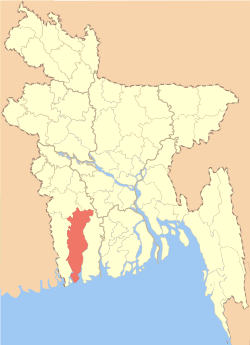 Location of Khulna in Bangladesh | |
| Coordinates: 22°21′N 89°18′E / 22.35°N 89.30°ECoordinates: 22°21′N 89°18′E / 22.35°N 89.30°E | |
| Country |
|
| Division | Khulna Division |
| Area | |
| • Total | 4,389.11 km2 (1,694.64 sq mi) |
| Population (2011 census) | |
| • Total | 2,318,527 |
| • Density | 530/km2 (1,400/sq mi) |
| Literacy rate | |
| • Total | 57.81% |
| Time zone | UTC+6 (BST) |
| Postal code | 9000 |
| Website |
www |
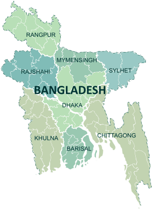
Khulna District (Bengali: খুলনা জেলা, Khulna Jela also Khulna Zila) is a district of Bangladesh. It is located in the Khulna Division. It is bordered on the north by the Jessore District and the Narail District, on the south by the Bay of Bengal, on the east by the Bagerhat District, and on the west by the Satkhira District.[1]
Ethnic groups and religions
History
Khulna is named after a goddess of the Hindu religion, Khulleshwari. In 1947, the district of Khulna had a slight Hindu majority of 52% but was included in Pakistan rather than India (see Radcliffe Line). Now the district's total population is about 80% Muslim. Now it is the third largest district in Bangladesh.
Geography and climate
Khulna District has a total area of 4,389.11 square kilometres (1,694.64 sq mi).[3] It borders Jessore District to the north, Narail District to the northeast, Bagerhat District to the east, the Bay of Bengal to the south, and Satkhira District to the west.[1]
Major rivers of Khulna District are the Rupsa (a continuation of the Bhairab and Atrai), Arpangachhia, Shibsa, Pasur, and the Koyra.[1]
Sub-districts
Khulna District (Zila) is divided into 9 upazilas and 8 metropolitan thanas (the latter forming the Khulna city area).
- Terokhada Upazila
- Batiaghata Upazila
- Dacope Upazila
- Dumuria Upazila
- Dighalia Upazila
- Koyra Upazila
- Paikgachha Upazila
- Phultala Upazila
- Rupsa Upazila
- Daulatpur Thana
- Khalishpur Thana
- Khan Jahan Ali Thana
- Khulna Kotwali Thana
- Sonadanga Thana
- Labanchara Thana
- Harintana Thana
- Arangghata Thana
Economy
Khulna is a port city. It is the most rapidly increasing city in the south. Mongla is the major sea port of the country. In Daulatpur there are several jute mills. By road, railway and riverway it is connected to other parts of the country. This infrastructure plays a vital role in the city's economy, which also depends upon fishing and salt industries. Khulna has a newsprint mill that will about reopen in the near future. The Khulna shipyard receives limited support from the Bangladesh Navy by building small, ocean-going ships. The Khulna textile and hardboard mills will reopen soon under private ownership.
Places of interest
- The Sundarbans is the largest mangrove forest in the world. The royal Bengal tiger inhabits the area; it is said that seeing the tiger enables a person to understand what a tiger means. There are many other rare animals in the area, including monkeys, chitra deer, crocodiles, wild cocks, wild pigs and thousands of kinds of birds.
- The historically famous Shait Gambuj Mosque (Sixty Dome Mosque) is in the Bagerhat District. It is famous for Khan Jahan Ali's mazar. A lake near the mosque has crocodiles. You can also visit Khulna Shipyard Ltd . It is the largest Shipyard in Bangladesh & It is also making the largest War ship for Bangladesh Navy.
- From Kuakata, both the rising and the setting of the sun into the ocean can be seen.
Education
Khulna is under the jurisdiction of the Jessore Education Board. This board varies the SSC and HSC standard.
BL College, Azam Khan Commerce College, Daulatpur College(Day-Night), Khulna University, KUET, Khulna Medical College etc. are the prominent educational institution in Khulna district.
See also
References
| Wikimedia Commons has media related to Khulna District. |
- 1 2 3 Sandipak Mallik (2012). "Khulna District". In Sirajul Islam and Ahmed A. Jamal. Banglapedia: National Encyclopedia of Bangladesh (Second ed.). Asiatic Society of Bangladesh.
- ↑ "C-1 Population By Religious Community". Government of Bangladesh.
- ↑ "District Statistics 2011: Khulna" (PDF). Bangladesh Bureau of Statistics. Retrieved October 29, 2017.
| Upazila/Thana: | ||
|---|---|---|