Delhi Gurgaon Expressway
| Delhi-Gurugram Expressway (दिल्ली गुरुग्राम एक्सप्रेसवे) | |
|---|---|
| Route information | |
| Length | 27.7 km (17.2 mi) |
| History | Completed in 2008 |
| Major junctions | |
| West end | Gurgaon/Manesar |
| East end | Delhi |
| Location | |
| States | Delhi, Haryana |
| Major cities | Delhi, Gurgaon(Now Gurugram) |
| Highway system | |
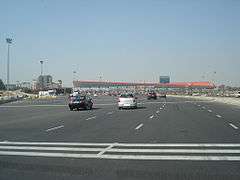
The 32-lane now adjunct toll gate at the Delhi-Gurugram border was the largest in South Asia and the second largest in Asia.[1]
Expressway also connects both cities with the airport
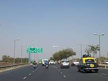
The Delhi-Gurugram Expressway is a 27.7 km (17.2 mi) six to eight lane[2] expressway connecting the national capital, Delhi and the Millennium city of Gurgaon (Now Gurugram), Haryana in the National Capital Region of India. The expressway is a part of the Golden Quadrilateral project, which itself is a part of the National Highway Development Project. The ₹10 billion (US$139.3 million), 27.7 km (17.2 mi) expressway was thrown open on January 23, 2008. This expressway is the busiest inter-city route in India and handles more than 180,000 PCUs daily.[3] It starts at Dhaula Kuan in Delhi and terminates on the outskirts of Gurgaon(Gurugram).
Authorities involved
See also
References
- ↑ "Excess cars made tolling a taxing truth at first: Expressway builder". Express India. Archived from the original on 20 November 2008. Retrieved 2010-09-16.
- ↑ "DSC Limited : Creating Infra Wealth". dsclimited. Retrieved 2015-07-10.
- ↑ TNN, Jan 8, 2009, 03.35am IST (2009-01-08). "Easy entry for Visa card holders- Times of India". The Times of India. Retrieved 2010-09-16.
External links
| Wikimedia Commons has media related to Delhi Gurgaon Expressway. |

| By state | |
|---|---|
| Types |
|
| Organisations | |
| See also | |
| |
This article is issued from
Wikipedia.
The text is licensed under Creative Commons - Attribution - Sharealike.
Additional terms may apply for the media files.