Faridabad district
| Faridabad district | |
|---|---|
| District of Haryana | |
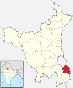 Location of Faridabad district in Haryana | |
| Country | India |
| State | Haryana |
| Administrative division | Faridabad |
| Headquarters | Faridabad |
| Tehsils | 1. Faridabad, 2. Ballabgarh |
| Area | |
| • Total | 2,151 km2 (831 sq mi) |
| Population (2011) | |
| • Total | 1,809,733 |
| • Density | 840/km2 (2,200/sq mi) |
| Demographics | |
| • Literacy | 83% |
| Website | Official website |
Faridabad district is one of the 22 districts of the Indian state of Haryana with Faridabad city the district headquarters. The Delhi-Mathura National Highway 2 (Shershah Suri Marg) passes through the centre of the district, which occupies an area of 2,151 square kilometres (831 sq mi) and as of the 2011 ensus of India had a population of 1,809,733 Haryana government has created a new Faridabad division which would cover the districts - Faridabad, Nuh and Palwal.[1]
As of 2011 it was the second most populous district of Haryana after Gurugram district.[2]
Origin of name
The district is named after its headquarters, Faridabad city, which in turn is named after its founder, Shaikh Farid, the treasurer of Jahangir who built a town here. On Talab Road near Gopi Colony (Old Faridabad), his tomb or maqbara can still be seen.
History
Faridabad district was carved out from erstwhile Gurgaon district on 15 August 1979 as the 12th district of Haryana.
Economy
Faridabad was formerly Haryana's leading industrial city and a popular choice for setting up industry due to its location on the Delhi-Mathura Road. However, the emergence of Gurgaon as a powerhouse for industrial development in the state[3] has led to its decline. The city is noted for its henna production in the agriculture sector while tractors, motorcycles, switch gears, refrigerators, shoes and tyres are other products made in the city. The IT revolution has completely bypassed Faridabad, opting instead for the cities of Noida, Okhla or Gurgaon. In part this was due to government apathy, in part due to the rising levels of pollution and congestion in the city.
Demographics
According to the 2011 census, Faridabad district has a population of 1,809,733,[2] roughly equal to the nation of The Gambia[4] or the US state of Nebraska.[5] This gives it a ranking of 266th in India (out of a total of 640).[2]
The district has a population density of 2,298 inhabitants per square kilometre (5,950/sq mi) .[2] Its population growth rate over the decade 2001–2011 was 31.75%.[2] Faridabad has a sex ratio of 871 females for every 1000 males,[2] and a literacy rate of 83%.[2]
Villages
There are large number of villages comes under Faridabad district. Some famous villages are Pali, Nangla Gujran, Pakhal, Neemka, Dhauj, Gazipur, Atali, Badkhal, Mohna, Tigaon, Jasana, Mujesar, Sikri.
References
- ↑ "Admn revamp: 2 divisions, one police range created". The Tribune. 3 January 2017. Retrieved 15 February 2017.
- 1 2 3 4 5 6 7 "District Census 2012". Census2011.co.in. 2011. Retrieved 2011-09-30.
- ↑ Athique, Adrian; Hill, Douglas (2009). The Multiplex in India: A Cultural Economy of Urban Leisure. Taylor & Francis. ISBN 978-1-135-18187-1.
- ↑ US Directorate of Intelligence. "Country Comparison:Population". Retrieved 2011-10-01.
Gambia, The 1,797,860 July 2011 est.
- ↑ "2010 Resident Population Data". U. S. Census Bureau. Archived from the original on 2013-10-19. Retrieved 2011-09-30.
Nebraska 1,826,341
- ↑ "Faridabad District : Census 2011 data". Retrieved 5 November 2017.
External links
Places adjacent to Faridabad district | ||||||||||
|---|---|---|---|---|---|---|---|---|---|---|
| ||||||||||