Outer Ring Road, Hyderabad
| Outer Ring Road,Hyderabad, Telangana | |
|---|---|
_at_Narsinghi.jpg) 8-lane ring road expressway | |
| Route information | |
| Length | 158 km (98 mi) |
| Existed | December 2005 – present |
| Location | |
| States | Telangana |
| Highway system | |
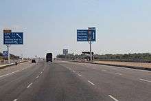
Nehru Outer Ring Road or Outer Ring Road is a 158 kilometer, 8-lane ring road expressway encircling the capital city of Hyderabad, Telangana, India. It is built by HMDA at a cost of ₹6,696 crores.[1] with an assistance of ₹3,123 crores from Japan International Cooperation Agency.[2] The expressway is designed for speeds up to 120 km/h.[3] A large part, 124 km (covering urban nodes viz., Hi- Tech city, Nanakramguda Financial District, Hyderabad International Airport, IKP Knowledge park, Hardware Park, Telangana State Police Academy, Singapore Financial District, and Games village) of the 158-km was opened by December 2012.[4]
It gives an easy connectivity between NH 44, NH 65, NH 161, NH 163 and NH 765 from Hyderabad to Srisailam as well as state highways leading to Vikarabad Nagarjunasagar and Karimnagar /Mancherial.[5] The Ring Road also helps in reducing the travel time from Rajiv Gandhi International Airport to cities like Nizamabad & Adilabad as it connects to NH44. The expressway is fenced and 33 radial roads connect it with the Inner Ring Road,[6] and the upcoming Regional Ring Road.
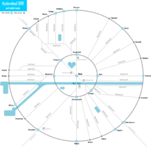
Route map
| Outer Ring Road, Hyderabad | ||||||||||||||||||||||||||||||||||||||||||||||||||||||||||||||||||||||||||||||||||||||||||||||||||||||||||||||||||||||||||||||||||||||||||||
|---|---|---|---|---|---|---|---|---|---|---|---|---|---|---|---|---|---|---|---|---|---|---|---|---|---|---|---|---|---|---|---|---|---|---|---|---|---|---|---|---|---|---|---|---|---|---|---|---|---|---|---|---|---|---|---|---|---|---|---|---|---|---|---|---|---|---|---|---|---|---|---|---|---|---|---|---|---|---|---|---|---|---|---|---|---|---|---|---|---|---|---|---|---|---|---|---|---|---|---|---|---|---|---|---|---|---|---|---|---|---|---|---|---|---|---|---|---|---|---|---|---|---|---|---|---|---|---|---|---|---|---|---|---|---|---|---|---|---|---|---|
| ||||||||||||||||||||||||||||||||||||||||||||||||||||||||||||||||||||||||||||||||||||||||||||||||||||||||||||||||||||||||||||||||||||||||||||
|
Information correct to 18 July 2016. | ||||||||||||||||||||||||||||||||||||||||||||||||||||||||||||||||||||||||||||||||||||||||||||||||||||||||||||||||||||||||||||||||||||||||||||
History
The construction started in December 2005 and the project was initiated by the then chief minister Y.S Raja Shekhar Reddy government and completed in phases by May 2018, after delays. The project was completed in 2 phases and is estimated to cost ₹3000 Crores.
- Phase I - Construction of 22 mi (35 km) Gachibowli to Shamshabad NH44 (₹500 Crores).
- Phase II - Construction of 140 mi (230 km) (₹2500 Crores).
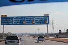
Exit & Entry Junctions
There are 14 junctions on the Outer Ring Road, they are:
- Shamshabad Junction
- Telangana State Police Academy Junction (TSPA Junction)
- Nanakramguda Junction
- Gachibowli Junction
- Pantancheru Junction
- Dommarapochampalli Junction
- Shamirpet Junction
- Cherial Junction
- Annojiguda Junction, Ghatkesar
- Pedda Amberpet Junction
- Bongloor Junction
- Kandlakoya Junction
The ORR passes through the villages in Ranga Reddy and Medak districts viz. Ghatkesar, Shamshabad, Tukkuguda, Kollur, Narsingi, Gachibowli, Patancheru, Bowrampet, Gowdavelli, Shamirpet, Pedda Amberpet, Bongloor and Medchal.
Traffic studies
The traffic studies on NH 44 and NH 65 concluded that a 4/6 lane road is due. The traffic movement on the existing inner ring road proved that the existing 4-lane road was inadequate. Due to the anticipated growth in the region and the development of proposed satellite townships around the ring road and beyond, an 8-lane carriageway was planned with a design life of 20 years.
The conclusion was to develop a highway with access control provides highway grade separations or interchanges for all intersecting highways. Once it had been decided to develop the route as an expressway, all intersecting highways should be terminated, rerouted or provided with a grade separation. The proposed corridor was access-controlled and limited access was to be provided at National Highway/SHI Major road crossings. A 2-lane service roads designed to carry two-way traffic, were proposed on both sides of the corridor. Low level underpasses were to be provided for connecting both the service roads at every 1–2 km, where the terrain permits.
Opening timeline
- 14 November 2008: Gachibowli – Narsingi – Shamshabad (for Hyderabad International Airport) (22 km)[16]
- 7 July 2010: Shamshabad – Pedda Amberpet (38 km)[17]
- 14 August 2011: Narsingi – Patancheru (23.7 km)[18]
- 3 December 2012: (part completed in 27 April 2018) Patancheru – Gowdavalli, and Kandlakoya – Shamirpet (38 km)[19]
- 4 March 2015: Pedda Amberpet – Ghatkesar (14 km)[20]
- 15 July 2016: Ghatkesar - Shameerpet (23 km)[21][22]
Land Acquisition
The First Phase land required was 750 acres (3.0 km2), out of which the private land acquired was 500 acres (2.0 km2). The land required for Second Phase is about 5,500 acres (22 km2), of which the Govt. land is about 1,000 acres (4.0 km2). The estimated Cost of Acquisition is ₹250 Crores.
Criticism
Much before the outer ring road (ORR) became a ring road, it underwent several changes in the road alignments. Influential farmers and realtors changed the alignment to best serve their interests at the cost of small and marginal farmers.[23]
The High Court of Andhra Pradesh passed a landmark judgement on 9 September 2010 in which the land acquisition proceedings were quashed for various reasons.[24]
See also
References
- ↑ Archived 6 December 2010 at the Wayback Machine.
- ↑ Archived 2 January 2011 at the Wayback Machine.
- ↑ ORR to be drivers delight. Ibnlive.in.com (2011-08-21). Retrieved on 2013-12-06.
- ↑ Another Outer Ring Road stretch to be opened today - Times Of India. Timesofindia.indiatimes.com (2012-12-03). Retrieved on 2013-12-06.
- ↑ Cities. Deccan Chronicle. Retrieved on 2013-12-06.
- ↑ HMDA seeks approval to work on 16 radial roads. The Hindu (2012-12-03). Retrieved on 2013-12-06.
- 1 2 3 "Medchal and Qutubullapur Mandal". Metropolitan Development Master Plan. Hyderabad Metropolitan Development Authority. Retrieved 21 July 2016.
- ↑ "Patancheruvu Mandal". Metropolitan Development Master Plan. Hyderabad Metropolitan Development Authority. Retrieved 21 July 2016.
- ↑ "Kisara Mandal". Metropolitan Development Master Plan. Hyderabad Metropolitan Development Authority. Retrieved 21 July 2016.
- 1 2 "Shankarpally, Serilingampally and Ramachandrapuram Mandal". Metropolitan Development Master Plan. Hyderabad Metropolitan Development Authority. Retrieved 21 July 2016.
- ↑ "Ghatkesar Mandal". Metropolitan Development Master Plan. Hyderabad Metropolitan Development Authority. Retrieved 21 July 2016.
- 1 2 3 "Hayathnagar Manda". Metropolita Development Master Plan. Hyderabad Metropolitan Development Authority. Retrieved 21 July 2016.
- 1 2 3 4 5 "Moinabad and Rajendranagar Mandal". Metropolitan Development Master Plan. Hyderabad Metropolitan Development Authority. Retrieved 21 July 2016.
- ↑ "Ibrahimpatanam and Manchal Mandal". Metropolitan Development Master Plan. Hyderabad Metropolitan Development Authority. Retrieved 21 July 2016.
- 1 2 "Maheshwaram Mandal". Metropolitan Development Master Plan. Hyderabad Metropolitan Development Authority. Retrieved 21 July 2016.
- ↑ "First phase of Hyderabad Outer Ring Road thrown open". Thaindian News.
- ↑ "For smooth traffic flow". The Hindu Business Line. Retrieved 5 January 2016.
- ↑ "Narsingi-Patancheru ORR stretch opened". IBNLive. Retrieved 5 January 2016.
- ↑ "Another Outer Ring Road stretch to be opened today - Times of India". The Times of India. Retrieved 5 January 2016.
- ↑ "ORR: Pedda Amberpet-Ghatkesar stretch opens". The Hindu. 5 March 2015. Retrieved 5 January 2016.
- ↑ "ORR: Ghatkesar - Shameerpet stretch opens". TOI. 15 July 2016. Retrieved 5 July 2016.
- ↑ "Work to be Resumed on ORR Kandlakoya Interchange". The New Indian Express. Retrieved 5 January 2016.
- ↑ Money, muscle decide outer ring road course - Times Of India. Timesofindia.indiatimes.com (2005-05-10). Retrieved on 2013-12-06.
- ↑
External links
| Wikimedia Commons has media related to Outer Ring Road, Hyderabad. |