Dearborn River
| Dearborn River | |
|---|---|
 | |
| Country | Cascade and Lewis and Clark County, Montana |
| Physical characteristics | |
| Main source | 47°18′33″N 112°49′10″W / 47.30917°N 112.81944°W[1] |
| River mouth |
3,432 feet (1,046 m)[1] 47°07′41″N 111°54′37″W / 47.12806°N 111.91028°WCoordinates: 47°07′41″N 111°54′37″W / 47.12806°N 111.91028°W[1] |
| Length | 70 mi (110 km) |
| Discharge |
|
| Basin features | |
| River system | Missouri River |
| Basin size | 410 sq mi (1,100 km2) |
The Dearborn River is a tributary of the Missouri River, approximately 70 mi (113 km) long, in central Montana in the United States. It rises in the Lewis and Clark National Forest, near Scapegoat Mountain[2] in the Lewis and Clark Range of the Rocky Mountains at the continental divide, in western Lewis and Clark County. It flows generally southeast through secluded canyons, and joins the Missouri near Craig.
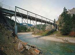
It is crossed by the Dearborn River High Bridge, which was constructed in 1897.
It is a popular destination for whitewater rafting and fly fishing. Whirling disease has become a significant problem among trout in the river.
The Dearborn is a Class I river for stream access for recreational purposes from the highway 431 bridge to its confluence with the Missouri river.[3]
See also
Notes
- 1 2 3 "Dearborn River". Geographic Names Information System. United States Geological Survey.
- ↑ Woodger, Elin; Toropov, Brandon (1 January 2009). Encyclopedia of the Lewis and Clark Expedition. Infobase Publishing. p. 112. ISBN 978-1-4381-1023-3.
- ↑ Stream Access in Montana Archived March 10, 2009, at the Wayback Machine.
