Crazy Mountains
| Crazy Mountains | |
|---|---|
 Crazy Mountains | |
| Highest point | |
| Peak | Crazy Peak |
| Elevation | 11,214 ft (3,418 m) |
| Coordinates | 46°01′04″N 110°16′36″W / 46.01778°N 110.27667°WCoordinates: 46°01′04″N 110°16′36″W / 46.01778°N 110.27667°W |
| Dimensions | |
| Length | 40 mi (64 km) N/S |
| Width | 15 mi (24 km) E/W |
| Area | 600 sq mi (1,600 km2) |
| Geography | |
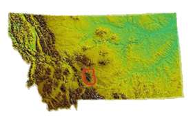 Location within Montana
| |
| Country | United States |
| State | Montana |
| Parent range | Rocky Mountains |
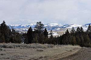
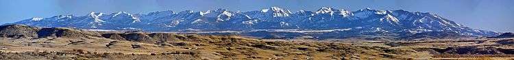
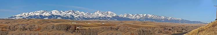
The Crazy Mountains, often called the Crazies, are a mountain range in the northern Rocky Mountains in the U.S. state of Montana.
Geography
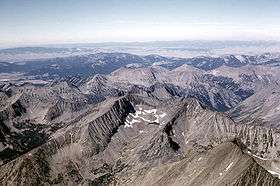
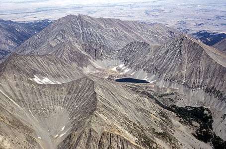
Spanning a distance of 40 miles (64 km), the Crazy Mountains are located between the Musselshell and Yellowstone rivers. The highest peak is Crazy Peak at 11,214 feet (3,418 m). Rising over 7,000 feet (2,130 m) above the Great plains to the east, the Crazies dominate their surroundings and are plainly visible just north of Interstate 90.
The Crazy Mountains form an isolated island range east of the Continental Divide. Other isolated ranges in Montana include the Castle Mountains, Little Belt Mountains, Big Snowy Mountains, Little Snowy Mountains, Highwood Mountains, Sweet Grass Hills, Bull Mountains and, in the southeastern corner of the state near Ekalaka, the Long Pines and Short Pines.
Geology
The Big Timber Stock, a large igneous intrusion, forms the bedrock in the Crazy Mountains.[1] The stock is of Tertiary age, and consists of diorite and gabbro with zones of Quartz Monzodiorite, and which has been intruded by many dikes and sills.
Geological features of the Crazy Mountains include:
Adjacent Counties
- Meagher County, Montana - north
- Sweet Grass County, Montana - east
- Park County, Montana - west, south
Wildlife
Due to the eastern location, these mountains are drier and less densely forested than other mountain ranges in Montana. There are at least 40 alpine lakes in the range, 15 of which are named. The Crazy Mountains sit in both Gallatin National Forest and Lewis and Clark National Forest. The Crazies support a healthy herd of mountain goats and the occasional elusive wolverine.
Access
The Crazies are almost completely surrounded by private lands making access into the mountains somewhat difficult, especially in the southern section where the highest peaks are located.[2][3]
Name origin
The name Crazy Mountains is said to be a shortened form of the name "Crazy Woman Mountains" given them, in compliment to their original Crow name, after a woman who went insane and lived in them after her family was killed in the westward settlement movement.[4]
The Crow people called the mountains Awaxaawapìa Pìa, roughly translated as "Ominous Mountains", or even rougher and less accurately, "Crazy Mountains". They were famous to the Crow people for having metaphysical powers and being unpredictable—a place used for vision quests.[5]

See also
Notes
- ↑ Preliminary geologic map of the Ringling 30' x 60' quadrangle, central Montana, by McDonald, Catherine, Lopez, D.A., Berg, R.B., and Gibson, R. I., Publishing Organization: Montana Bureau of Mines and Geology, Series and Number: Open-File Reports 511. Publication Date: 2005 Map Scale: 1:100,000
- ↑ Reel, Monte. "This Land Is No Longer Your Land". Bloomberg. Retrieved 23 January 2018.
- ↑ McLaughlin, Kathleen (21 Jan 2018). "Class war in the American west: the rich landowners blocking access to public lands". Guardian News. Retrieved 23 January 2018.
- ↑
- (This is an apocryphal account likely based more on myth than reality. The name is said to have arisen out of a translation error between early white explorers and the Crow natives who valued the Crazy Mountains as a location for vision quests. They attempted to convey this to the explorers, who, likely confused by the notions of vision quest, came to understand the Crazies as a place where one goes crazy.) Melroy, Mark (1986). Islands on the Prairie-The Mountain Ranges of Eastern Montana-Montana Geographic Series #13. Helena, Montana: Montana Magazine. p. 100. ISBN 0-938314-24-6.
- ↑ "Foundation Document for Honoring Tribal Legacies: An Epic Journey of Healing". University of Oregon and National Park Service. Missing or empty
|url=(help);|access-date=requires|url=(help)
External links
| Wikimedia Commons has media related to Crazy Mountains. |
- Crazy Mountains: Backdrop to Big Timber SweetgrassCounty.Com
- Fishing, Hiking and Camping in the Crazy Mountains BigSkyFishing.Com
- "Crazy Mountains". Peakbagger.com.
