Stone County, Arkansas
| Stone County, Arkansas | |
|---|---|
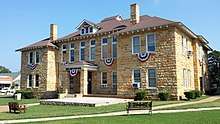 Stone County courthouse in Mountain View | |
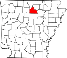 Location in the U.S. state of Arkansas | |
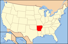 Arkansas's location in the U.S. | |
| Founded | April 21, 1873 |
| Seat | Mountain View |
| Largest city | Mountain View |
| Area | |
| • Total | 609.43[1] sq mi (1,578 km2) |
| • Land | 606.59[1] sq mi (1,571 km2) |
| • Water | 2.84[1] sq mi (7 km2), 0.5%[1] |
| Population (est.) | |
| • (2016) | 12,539 |
| • Density | 20/sq mi (8/km2) |
| Congressional district | 1st |
| Time zone | Central: UTC−6/−5 |
Stone County is located in the Ozark Mountains in the U.S. state of Arkansas. The county is named for rugged, rocky area terrain of the Ozarks. Created as Arkansas's 74th county on April 21, 1873, Randolph County has two incorporated cities: Mountain View, the county seat and most populous city, and Fifty-Six. The county is also the site of numerous unincorporated communities and ghost towns.
Most of the county is sparsely populated forested Ozark hills; including the northern fifth of the county managed by the United States Forest Service as the Ozark National Forest. The remainder of the county is used for poultry, ranching, and timber production. The White River runs along the eastern boundary of Stone County. The county contains six protected areas in addition to the Ozark National Forest: Blanchard Springs Caverns within the Ozark National Forest, two Natural Areas, two Wildlife Management Areas and the Ozark Folk Center, which preserves and interprets Ozark cultural heritage, especially traditional mountain folk music and crafts. Other features such as log cabins, one-room school houses, community centers, and museums, as well as annual cultural events, preserve the history and culture of Stone County.
Randolph County occupies 609.43 square miles (1,578.4 km2) and contained a population of 12,394 people in 5,325 households as of the 2010 Census, ranking it 57th in both size and population among the state's 75 counties.
Geography
Stone County is located in the Ozark Mountains, one of the six ecoregions of Arkansas. The Ozarks are a mountainous subdivision of the U.S. Interior Highlands, and Stone County contains the Springfield Plateau, Salem Plateau, and the relatively steeper Boston Mountains subsets. The county is roughly split along an east-west line near Mountain View, the centrally located county seat,[2] with areas north within the Springfield Plateau, and areas south within the Boston Mountains. Areas along the White River, which forms the county's northeastern boundary, are dissected bluffs of the Salem Plateau rather than riparian floodplains.[3] According to the U.S. Census Bureau, the county has a total area of 609.43 square miles (1,578.4 km2), of which 606.59 square miles (1,571.1 km2) is land and 2.84 square miles (7.4 km2) (0.5%) is water.[1]
The county is located approximately 105 miles (169 km) north of Little Rock, 151 miles (243 km) northwest of Memphis, Tennessee, and 278 miles (447 km) southwest of St. Louis, Missouri.[Note 1] Stone County is surrounded by three Ozark counties, Searcy County to the west, Baxter County to the northwest, Izard County to the northeast, and three border counties with the Arkansas River Valley, Van Buren County to the southwest, Cleburne County to the south, and Independence County (which also contains a small piece of the Arkansas Delta) to the east.
Hydrology
National protected area
- Ozark National Forest (part)
Demographics
| Historical population | |||
|---|---|---|---|
| Census | Pop. | %± | |
| 1880 | 5,089 | — | |
| 1890 | 7,043 | 38.4% | |
| 1900 | 8,100 | 15.0% | |
| 1910 | 8,946 | 10.4% | |
| 1920 | 8,779 | −1.9% | |
| 1930 | 7,993 | −9.0% | |
| 1940 | 8,603 | 7.6% | |
| 1950 | 7,662 | −10.9% | |
| 1960 | 6,294 | −17.9% | |
| 1970 | 6,838 | 8.6% | |
| 1980 | 9,022 | 31.9% | |
| 1990 | 9,775 | 8.3% | |
| 2000 | 11,499 | 17.6% | |
| 2010 | 12,394 | 7.8% | |
| Est. 2016 | 12,539 | [5] | 1.2% |
| U.S. Decennial Census[6] 1790–1960[7] 1900–1990[8] 1990–2000[9] 2010–2016[10] | |||
2010 Census
As of the 2010 census,[11] there were 12,394 people, 5,325 households, and 3,590 families residing in the county. The population density was 20 people per square mile (7.9/km²). There were 6,712 housing units at an average density of 11 per square mile (4.3/km²). The racial makeup of the county was 96.8% White, 0.1% Black or African American, 0.7% Native American, 0.4% Asian, 0.0% Pacific Islander, 0.4% from other races, and 1.6% from two or more races. 1.3% of the population were Hispanic or Latino of any race.
There were 5,325 households out of which 26.0% had children under the age of 18 living with them, 67.4% were married couples living together, 7.2% had a female householder with no husband present, and 32.6% were non-families. 28.9% of all households were made up of individuals and 36.6% had someone living alone who was 65 years of age or older. The average household size was 2.30 and the average family size was 2.81.
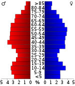
In the county, the population was spread out with 20.6% under the age of 18, 6.2% from 18 to 24, 19.4% from 25 to 44, 31.0% from 45 to 64, and 22.8% who were 65 years of age or older. The median age was 37.2 years. For every 100 females there were 97.8 males. For every 100 females age 18 and over, there were 96.2 males.
The median income for a household in the county was $30,380, and the median income for a family was $36,765.[12] Males had a median income of $28,258 versus $25,341 for females.[13] The per capita income for the county was $16,090. About 16.6% of families and 23.4% of the population were below the poverty line, including 35.7% of those under age 18 and 20.6% of those age 65 or over.[14]
2000 Census
As of the 2000 census,[16] there were 11,499 people, 4,768 households, and 3,461 families residing in the county. The population density was 19 people per square mile (7/km²). There were 5,715 housing units at an average density of 9 per square mile (4/km²). The racial makeup of the county was 97.27% White, 0.08% Black or African American, 0.77% Native American, 0.05% Asian, 0.03% Pacific Islander, 0.15% from other races, and 1.64% from two or more races. 1.08% of the population were Hispanic or Latino of any race.
There were 4,768 households out of which 26.90% had children under the age of 18 living with them, 62.30% were married couples living together, 7.10% had a female householder with no husband present, and 27.40% were non-families. 24.80% of all households were made up of individuals and 11.20% had someone living alone who was 65 years of age or older. The average household size was 2.38 and the average family size was 2.82.
In the county, the population was spread out with 22.20% under the age of 18, 7.10% from 18 to 24, 23.60% from 25 to 44, 28.50% from 45 to 64, and 18.60% who were 65 years of age or older. The median age was 43 years. For every 100 females there were 96.90 males. For every 100 females age 18 and over, there were 95.30 males.
The median income for a household in the county was $22,209, and the median income for a family was $28,009. Males had a median income of $20,904 versus $16,118 for females. The per capita income for the county was $14,134. About 14.10% of families and 18.90% of the population were below the poverty line, including 26.20% of those under age 18 and 12.10% of those age 65 or over.
Government
The county government is a constitutional body granted specific powers by the Constitution of Arkansas and the Arkansas Code. The quorum court is the legislative branch of the county government and controls all spending and revenue collection. Representatives are called justices of the peace and are elected from county districts every even-numbered year. The number of districts in a county vary from nine to fifteen, and district boundaries are drawn by the county election commission. The Stone County Quorum Court has nine members.[17] Presiding over quorum court meetings is the county judge, who serves as the chief operating officer of the county. The county judge is elected at-large and does not vote in quorum court business, although capable of vetoing quorum court decisions.[18][19]
| Year | GOP | Dem | Others |
|---|---|---|---|
| 2016 | 73.75% 4,113 | 21.57% 1,203 | 4.68% 261 |
| 2012 | 70.53% 3,776 | 25.33% 1,356 | 4.15% 222 |
| 2008 | 66.38% 3,534 | 30.02% 1,598 | 3.61% 192 |
| 2004 | 57.45% 3,188 | 40.64% 2,255 | 1.91% 106 |
| 2000 | 53.97% 2,623 | 42.04% 2,043 | 4.00% 194 |
| 1996 | 34.36% 1,526 | 50.15% 2,227 | 15.49% 688 |
| 1992 | 33.18% 1,672 | 52.03% 2,622 | 14.78% 745 |
| 1988 | 55.17% 2,186 | 43.61% 1,728 | 1.21% 48 |
| 1984 | 57.48% 2,325 | 40.89% 1,654 | 1.63% 66 |
| 1980 | 45.11% 1,793 | 49.51% 1,968 | 5.39% 214 |
| 1976 | 27.06% 1,014 | 72.54% 2,718 | 0.40% 15 |
| 1972 | 67.38% 1,989 | 32.45% 958 | 0.17% 5 |
| 1968 | 37.05% 987 | 26.20% 698 | 36.75% 979 |
| 1964 | 40.26% 942 | 58.72% 1,374 | 1.03% 24 |
| 1960 | 49.36% 959 | 46.17% 897 | 4.48% 87 |
| 1956 | 46.14% 651 | 53.58% 756 | 0.28% 4 |
| 1952 | 54.95% 700 | 44.98% 573 | 0.08% 1 |
| 1948 | 33.56% 644 | 61.80% 1,186 | 4.64% 89 |
| 1944 | 47.57% 549 | 51.30% 592 | 1.13% 13 |
| 1940 | 38.41% 406 | 60.93% 644 | 0.66% 7 |
| 1936 | 32.12% 248 | 67.49% 521 | 0.39% 3 |
| 1932 | 18.78% 261 | 79.14% 1,100 | 2.09% 29 |
| 1928 | 43.62% 499 | 54.90% 628 | 1.49% 17 |
| 1924 | 32.31% 210 | 59.38% 386 | 8.31% 54 |
| 1920 | 39.25% 367 | 55.19% 516 | 5.56% 52 |
| 1916 | 30.41% 298 | 69.59% 682 | 0.00% 0 |
| 1912 | 18.46% 113 | 55.07% 337 | 26.47% 162 |
| 1908 | 33.33% 267 | 61.92% 496 | 4.74% 38 |
| 1904 | 43.15% 233 | 51.30% 277 | 5.56% 30 |
| 1900 | 30.28% 231 | 68.15% 520 | 1.57% 12 |
| 1896 | 18.96% 172 | 80.26% 728 | 0.77% 7 |
Communities
Cities
- Fifty-Six
- Mountain View (county seat)
Unincorporated communities
- Alco
- Allison
- Arlberg
- Bothersome, historic
- Buckhorn, historic
- Chalybeate Springs
- Flag
- Fox
- Hanover
- Harness, historic
- Hedges, historic
- Luber
- Kahoka
- Marcella
- Meadow Creek
- Melrose
- Mozart
- Newnata
- Old Lexington
- Onia
- Optimus
- Parma
- Pleasant Grove, aka Red Stripe
- Pleasant Hill
- Red Stripe, historic
- Rushing
- Shaved Navel, historic
- St. James, fka Shaved Navel, fka Buckhorn
- Sunnyland
- Timbo
- Turkey Creek
- West Richwoods
Townships
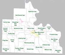
Townships in Arkansas are the divisions of a county. Each township includes unincorporated areas; some may have incorporated cities or towns within part of their boundaries. Arkansas townships have limited purposes in modern times. However, the United States Census does list Arkansas population based on townships (sometimes referred to as "county subdivisions" or "minor civil divisions"). Townships are also of value for historical purposes in terms of genealogical research. Each town or city is within one or more townships in an Arkansas county based on census maps and publications. The townships of Stone County are listed below; listed in parentheses are the cities, towns, and/or census-designated places that are fully or partially inside the township. [21][22]
- Arbana (small part of Mountain View)
- Blue Mountain (most of Mountain View)
- Bryan
- Farris
- Flag
- Franklin
- Harris (small part of Mountain View)
- Jones
- Liberty
- Locust Grove
- Marcella
- Northwest (Fifty-Six)
- Optimus
- Red River
- Red Stripe
- Richwoods
- Roasting Ear
- Smart
- Sylamore
- Timbo
- Turkey Creek
- Union
- Washington
- Wilson
Infrastructure
Major highways
The county also contains the Sylamore Scenic Byway.
See also
Notes
References
- 1 2 3 4 5 Arkansas State Highway and Transportation Department in cooperation with the U.S. Department of Transportation (2014-10-16). Arkansas County Polygons (SHP file) (Map). Arkansas GIS Office. Retrieved January 1, 2017.
- ↑ Transportation Planning and Policy Division (October 6, 2016) [October 31, 2001]. General Highway Map, Stone County, Arkansas (PDF) (Map) (Revised ed.). 1:62,500. Little Rock: Arkansas State Highway and Transportation Department. OCLC 919441822. Retrieved September 23, 2018.
- ↑

- ↑ "Google Maps (Search for Mountain View, AR)". Google. Retrieved September 23, 2018.
- ↑ "Population and Housing Unit Estimates". Retrieved June 9, 2017.
- ↑ "U.S. Decennial Census". United States Census Bureau. Retrieved August 27, 2015.
- ↑ "Historical Census Browser". University of Virginia Library. Retrieved August 27, 2015.
- ↑ Forstall, Richard L., ed. (March 27, 1995). "Population of Counties by Decennial Census: 1900 to 1990". United States Census Bureau. Retrieved August 27, 2015.
- ↑ "Census 2000 PHC-T-4. Ranking Tables for Counties: 1990 and 2000" (PDF). United States Census Bureau. April 2, 2001. Retrieved August 27, 2015.
- ↑ "State & County QuickFacts". United States Census Bureau. Archived from the original on July 15, 2011. Retrieved May 19, 2014.
- ↑ "American FactFinder". United States Census Bureau. Retrieved September 25, 2018.
- ↑ "Earnings in the Past 12 Months". United States Census Bureau. 2010. Missing or empty
|url=(help);|access-date=requires|url=(help) - ↑ "Income in the Past 12 Months". United States Census Bureau. 2010. Retrieved September 25, 2018.
- ↑ "Selected Economic Characteristics". United States Census Bureau. 2010. Retrieved September 25, 2018.
- ↑ Based on 2000 census data
- ↑ "American FactFinder". United States Census Bureau. Retrieved 2011-05-14.
- ↑ "Stone County". Association of Arkansas Counties. Retrieved September 25, 2018.
- ↑ Teske, Steven (March 24, 2014). "Quorum Courts". Encyclopedia of Arkansas History and Culture. Butler Center for Arkansas Studies at the Central Arkansas Library System. Retrieved January 23, 2016.
- ↑ Goss, Kay C. (August 28, 2015). "Office of County Judge". Encyclopedia of Arkansas History and Culture. Butler Center for Arkansas Studies at the Central Arkansas Library System. Retrieved January 23, 2016.
- ↑ "Dave Leip's Atlas of U.S. Presidential Elections". Retrieved November 18, 2016.
- ↑ 2011 Boundary and Annexation Survey (BAS): Stone County, AR (PDF) (Map). U. S. Census Bureau. Archived from the original (PDF) on 2012-10-19. Retrieved 2011-08-07.
- ↑ "Arkansas: 2010 Census Block Maps - County Subdivision". United States Census Bureau. Retrieved May 29, 2014.
External links
Places adjacent to Stone County, Arkansas | ||||||||||
|---|---|---|---|---|---|---|---|---|---|---|
| ||||||||||
Municipalities and communities of Stone County, Arkansas, United States | ||
|---|---|---|
| Cities | | |
| Unincorporated communities | ||
| Ghost town | ||

Coordinates: 35°52′46″N 92°08′50″W / 35.87944°N 92.14722°W