Drew County, Arkansas
| Drew County, Arkansas | |
|---|---|
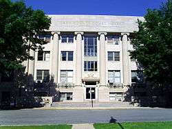 Drew County Courthouse in Monticello | |
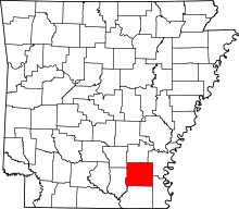 Location in the U.S. state of Arkansas | |
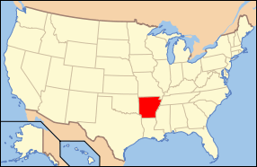 Arkansas's location in the U.S. | |
| Founded | November 26, 1846 |
| Named for | Thomas Drew |
| Seat | Monticello |
| Largest city | Monticello |
| Area | |
| • Total | 836 sq mi (2,165 km2) |
| • Land | 828 sq mi (2,145 km2) |
| • Water | 7.3 sq mi (19 km2), 0.9% |
| Population (est.) | |
| • (2016) | 18,651 |
| • Density | 22/sq mi (8/km2) |
| Congressional district | 4th |
| Time zone | Central: UTC−6/−5 |
| Website |
drewcounty |
Drew County is a county located in the southeast region of the U.S. state of Arkansas. As of the 2010 census, the population was 18,509, making it the thirty-ninth most populous of Arkansas's seventy-five counties.[1] The county seat and largest city is Monticello.[2] Drew County was formed on November 26, 1846, and named for Thomas Drew,[3] the third governor of Arkansas.
Located on the edge of the Arkansas Timberlands and the Arkansas Delta, its fertile soils produced prosperity for early settlers in the antebellum era. Cotton was the major commodity crop, but corn, apples, peaches and tomatoes were also grown. Following the Civil War, the boundaries of Drew County changed.
In the late 19th and early 20th centuries, timber harvesting became an important industry. As a variety of industries began to move to the county, several colleges were founded in the county in the early part of the 20th century, one developing as University of Arkansas at Monticello. Today, the county has a diverse economy and is an economic center in southeast Arkansas.
Geography
According to the U.S. Census Bureau, the county has a total area of 836 square miles (2,170 km2), of which 828 square miles (2,140 km2) is land and 7.3 square miles (19 km2) (0.9%) is water.[4]
Loggy Bayou is a swamp in Drew County, not to be confused with a bayou of the same name in northwestern Louisiana.
Major highways
Adjacent counties
- Lincoln County (north)
- Desha County (northeast)
- Chicot County (southeast)
- Ashley County (south)
- Bradley County (west)
- Cleveland County (northwest)
Demographics
| Historical population | |||
|---|---|---|---|
| Census | Pop. | %± | |
| 1850 | 3,276 | — | |
| 1860 | 9,078 | 177.1% | |
| 1870 | 9,960 | 9.7% | |
| 1880 | 12,231 | 22.8% | |
| 1890 | 17,352 | 41.9% | |
| 1900 | 19,451 | 12.1% | |
| 1910 | 21,960 | 12.9% | |
| 1920 | 21,822 | −0.6% | |
| 1930 | 19,928 | −8.7% | |
| 1940 | 19,831 | −0.5% | |
| 1950 | 17,959 | −9.4% | |
| 1960 | 15,213 | −15.3% | |
| 1970 | 15,157 | −0.4% | |
| 1980 | 17,910 | 18.2% | |
| 1990 | 17,369 | −3.0% | |
| 2000 | 18,723 | 7.8% | |
| 2010 | 18,509 | −1.1% | |
| Est. 2016 | 18,651 | [5] | 0.8% |
| U.S. Decennial Census[6] 1790–1960[7] 1900–1990[8] 1990–2000[9] 2010–2016[1] | |||

As of the 2000 census,[11] there were 18,723 people, 7,337 households, and 5,091 families residing in the county. The population density was 23 people per square mile (9/km²). There were 8,287 housing units at an average density of 10 per square mile (4/km²). The racial makeup of the county was 70.30% White, 27.16% Black or African American, 0.25% Native American, 0.42% Asian, 0.02% Pacific Islander, 1.00% from other races, and 0.85% from two or more races. 1.76% of the population were Hispanic or Latino of any race.
There were 7,337 households out of which 33.50% had children under the age of 18 living with them, 51.30% were married couples living together, 14.20% had a female householder with no husband present, and 30.60% were non-families. 26.00% of all households are made and 10.50% had someone living alone who was 65 years of age or older. The average household size was 2.46 and the average family size was 2.97.
In the county, the population was spread out with 25.80% under the age of 18, 12.60% from 18 to 24, 27.20% from 25 to 44, 21.50% from 45 to 64, and 12.80% who were 65 years of age or older. The median age was 34 years. For every 100 females there were 94.10 males. For every 100 females age 18 and over, there were 91.50 males.
The median income for a household in the county was $28,627, and the median income for a family was $37,317. Males had a median income of $30,794 versus $20,707 for females. The per capita income for the county was $16,264. About 13.10% of families and 18.20% of the population were below the poverty line, including 21.90% of those under age 18 and 21.80% of those age 65 or over.
Government
| Year | GOP | Dem | Others |
|---|---|---|---|
| 2016 | 60.17% 3,968 | 35.86% 2,365 | 3.98% 262 |
| 2012 | 58.60% 3,887 | 39.65% 2,630 | 1.75% 116 |
| 2008 | 58.40% 3,860 | 39.30% 2,598 | 2.30% 152 |
| 2004 | 52.20% 3,262 | 47.24% 2,952 | 0.56% 35 |
| 2000 | 46.54% 2,756 | 51.67% 3,060 | 1.79% 106 |
| 1996 | 29.20% 1,657 | 62.91% 3,570 | 7.89% 448 |
| 1992 | 30.77% 1,938 | 59.51% 3,748 | 9.71% 612 |
| 1988 | 53.29% 2,995 | 45.87% 2,578 | 0.84% 47 |
| 1984 | 56.10% 3,407 | 43.44% 2,638 | 0.46% 28 |
| 1980 | 36.74% 2,272 | 60.75% 3,757 | 2.50% 155 |
| 1976 | 31.57% 1,730 | 68.43% 3,750 | |
| 1972 | 74.06% 3,334 | 25.94% 1,168 | 0.00% 0 |
| 1968 | 22.27% 1,040 | 28.35% 1,324 | 49.39% 2,307 |
| 1964 | 51.18% 2,109 | 48.05% 1,980 | 0.78% 32 |
| 1960 | 26.36% 889 | 62.49% 2,107 | 11.15% 376 |
| 1956 | 35.28% 1,265 | 62.30% 2,234 | 2.43% 87 |
| 1952 | 31.46% 1,040 | 68.39% 2,261 | 0.15% 5 |
| 1948 | 8.98% 182 | 59.40% 1,204 | 31.62% 641 |
| 1944 | 18.92% 320 | 81.02% 1,370 | 0.06% 1 |
| 1940 | 10.06% 152 | 87.95% 1,329 | 1.99% 30 |
| 1936 | 5.38% 70 | 94.47% 1,229 | 0.15% 2 |
| 1932 | 10.06% 198 | 89.39% 1,760 | 0.56% 11 |
| 1928 | 25.56% 500 | 74.23% 1,452 | 0.20% 4 |
| 1924 | 35.12% 563 | 63.51% 1,018 | 1.37% 22 |
| 1920 | 35.17% 773 | 63.56% 1,397 | 1.27% 28 |
| 1916 | 34.00% 838 | 66.00% 1,627 | 0.00% 0 |
| 1912 | 26.45% 424 | 55.02% 882 | 18.53% 297 |
| 1908 | 36.54% 679 | 60.44% 1,123 | 3.01% 56 |
| 1904 | 37.44% 593 | 60.16% 953 | 2.40% 38 |
| 1900 | 33.77% 569 | 65.22% 1,099 | 1.01% 17 |
| 1896 | 25.46% 603 | 74.07% 1,754 | 0.46% 11 |
Communities
Cities
- Monticello (county seat)
- Tillar (partly in Desha County)
- Wilmar
Towns
Townships
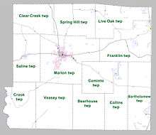
Townships in Arkansas are the divisions of a county. Each township includes unincorporated areas; some may have incorporated cities or towns within part of their boundaries. Arkansas townships have limited purposes in modern times. However, the United States Census does list Arkansas population based on townships (sometimes referred to as "county subdivisions" or "minor civil divisions"). Townships are also of value for historical purposes in terms of genealogical research. Each town or city is within one or more townships in an Arkansas county based on census maps and publications. The townships of Drew County are listed below; listed in parentheses are the cities, towns, and/or census-designated places that are fully or partially inside the township. [13][14]
- Bartholomew (contains Jerome)
- Bearhouse
- Clear Creek
- Collins
- Cominto
- Crook
- Franklin (contains part of Tillar)
- Live Oak (contains Winchester)
- Marion (contains Monticello)
- Saline (contains Wilmar)
- Spring Hill
- Veasey
Source:[15]
See also
References
- 1 2 "State & County QuickFacts". United States Census Bureau. Archived from the original on July 9, 2011. Retrieved May 20, 2014.
- ↑ "Find a County". National Association of Counties. Archived from the original on 2011-05-31. Retrieved 2011-06-07.
- ↑ Gannett, Henry (1905). The Origin of Certain Place Names in the United States. Govt. Print. Off. p. 109.
- ↑ "2010 Census Gazetteer Files". United States Census Bureau. August 22, 2012. Retrieved August 26, 2015.
- ↑ "Population and Housing Unit Estimates". Retrieved June 9, 2017.
- ↑ "U.S. Decennial Census". United States Census Bureau. Archived from the original on May 12, 2015. Retrieved August 26, 2015.
- ↑ "Historical Census Browser". University of Virginia Library. Retrieved August 26, 2015.
- ↑ Forstall, Richard L., ed. (March 27, 1995). "Population of Counties by Decennial Census: 1900 to 1990". United States Census Bureau. Retrieved August 26, 2015.
- ↑ "Census 2000 PHC-T-4. Ranking Tables for Counties: 1990 and 2000" (PDF). United States Census Bureau. April 2, 2001. Retrieved August 26, 2015.
- ↑ Based on 2000 census data
- ↑ "American FactFinder". United States Census Bureau. Archived from the original on 2013-09-11. Retrieved 2011-05-14.
- ↑ "Dave Leip's Atlas of U.S. Presidential Elections". Retrieved November 18, 2016.
- ↑ 2011 Boundary and Annexation Survey (BAS): Drew County, AR (PDF) (Map). U. S. Census Bureau. Archived from the original (PDF) on 2012-10-19. Retrieved 2011-08-07.
- ↑ "Arkansas: 2010 Census Block Maps - County Subdivision". United States Census Bureau. Retrieved May 28, 2014.
- ↑
"Summary Population and Housing Characteristics, CPH-1-5, Arkansas" (PDF). 2010 Census of Population and Housing. United States Census Bureau. September 2012. Retrieved May 31, 2014. External link in
|work=(help)
Places adjacent to Drew County, Arkansas | ||||||||||
|---|---|---|---|---|---|---|---|---|---|---|
| ||||||||||
Municipalities and communities of Drew County, Arkansas, United States | ||
|---|---|---|
| Cities | | |
| Towns | ||
| Unincorporated communities | ||
| Footnotes | ‡This populated place also has portions in an adjacent county or counties | |
Coordinates: 33°35′04″N 91°43′51″W / 33.58444°N 91.73083°W