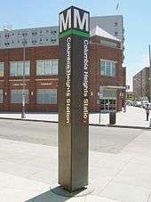
Columbia Heights station
Columbia Heights | ||||||||||||||||
|---|---|---|---|---|---|---|---|---|---|---|---|---|---|---|---|---|
|
| ||||||||||||||||
 | ||||||||||||||||
| Location |
3030 14th Street NW Washington, DC 20009 | |||||||||||||||
| Owned by | WMATA | |||||||||||||||
| Line(s) |
| |||||||||||||||
| Platforms | 1 island platform | |||||||||||||||
| Tracks | 2 | |||||||||||||||
| Connections |
| |||||||||||||||
| Construction | ||||||||||||||||
| Bicycle facilities | 4 racks, 12 lockers | |||||||||||||||
| Disabled access | Yes | |||||||||||||||
| Other information | ||||||||||||||||
| Station code | E04 | |||||||||||||||
| History | ||||||||||||||||
| Opened | September 18, 1999 | |||||||||||||||
| Traffic | ||||||||||||||||
| Passengers (2017) |
10,679 daily [1] | |||||||||||||||
| Services | ||||||||||||||||
| ||||||||||||||||
Columbia Heights is a Washington Metro station in Washington, D.C., on the Green and Yellow Lines. Due to successful redevelopment since the station's opening, Columbia Heights is one of the busiest Metro stops outside the downtown core, with over four million exits in 2010.[2]
Location
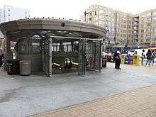
The station is located in Northwest Washington at 14th and Irving Streets (entrances at both the Southwest and Northeast corners), serving both the Columbia Heights and Mount Pleasant neighborhoods. It is also close to the Adams Morgan neighborhood. Service began on September 18, 1999.
Public art
Installed in 1999, Woven Identities is a mural and wall sculpture located in the Metro station. Installed as part of the DC Commission on the Arts and Humanities public art agenda the piece was created by D.C. architect Meghan Walsh,AIA and youth from Casa Del Pueblo Community Center. A series of painted panels, which appear like mosaics, the mural is abstract featuring faces representing the diversity of the Columbia Heights neighborhood. Neon lights of many colors glow from behind the framed painted mosaics.[3]
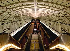
Station layout
| G | Street level | Exit/entrance |
| M | Mezzanine | One-way faregates, ticket machines, station agent |
| P Platform level |
Southbound | ← ← |
| Island platform, doors will open on the left | ||
| Northbound | → → | |
References
- ↑ "Metrorail Average Weekday Passenger Boardings" (PDF). WMATA. Retrieved August 29, 2018.
- ↑ "Columbia Heights neighborhood profile" (PDF). WDCEP. Retrieved May 16, 2012.
- ↑ WMATA (2010). "Columbia Heights Station". Art by Metro Line: Green Line. Washington Metropolitan Area Transit Authority. Retrieved December 18, 2010.
External links
| Wikimedia Commons has media related to Columbia Heights (WMATA station). |
- WMATA: Columbia Heights Station
- StationMasters Online: Columbia Heights Station
- The Schumin Web Transit Center: Columbia Heights Station
- Irving Street west entrance from Google Maps Street View
- Irving Street east entrance from Google Maps Street View
Coordinates: 38°55′43″N 77°01′57″W / 38.928718°N 77.032442°W