Pine Level, Coffee County, Alabama
| Pine Level, Alabama | |
|---|---|
| Unincorporated community | |
 Pine Level, Alabama  Pine Level, Alabama | |
| Coordinates: 31°28′33″N 86°11′11″W / 31.47583°N 86.18639°WCoordinates: 31°28′33″N 86°11′11″W / 31.47583°N 86.18639°W | |
| Country | United States |
| State | Alabama |
| County | Coffee |
| Elevation | 472 ft (144 m) |
| Time zone | UTC-6 (Central (CST)) |
| • Summer (DST) | UTC-5 (CDT) |
| Area code(s) | 334 |
| GNIS feature ID | 124825[1] |
Pine Level is an unincorporated community in Coffee County, Alabama, United States. Pine Level is located on Alabama State Route 141, 8.2 miles (13.2 km) northwest of Elba.
References
Municipalities and communities of Coffee County, Alabama, United States | ||
|---|---|---|
| Cities | 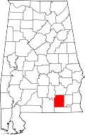 | |
| Towns | ||
| Unincorporated communities | ||
| Footnotes | ‡This populated place also has portions in an adjacent county or counties | |
This article is issued from
Wikipedia.
The text is licensed under Creative Commons - Attribution - Sharealike.
Additional terms may apply for the media files.