Clayton Historic District (Clayton, New York)
|
Clayton Historic District | |
 | |
  | |
| Location |
203-215 & 200-326 James St., 500-544 & 507-537 Riverside Dr., (original) |
|---|---|
| Coordinates | 44°14′31″N 76°5′22″W / 44.24194°N 76.08944°WCoordinates: 44°14′31″N 76°5′22″W / 44.24194°N 76.08944°W |
| Built | 1854 |
| Architect | Multiple |
| Architectural style |
Italianate, Romanesque (original) Late Victorian, Late 19th And 20th Century Revivals (increase) |
| NRHP reference # | 85002368 and 97000424[1] |
| Added to NRHP |
September 12, 1985 (original) May 09, 1997 (increase)[1] |
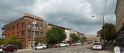
Clayton Historic District is a historic district in Clayton, New York. It was originally listed on the National Register of Historic Places in 1985, and later its boundaries were increased in 1997.[2][3]
It includes the Capt. Simon Johnston House, which is separately listed on the National Register.
References
- 1 2 National Park Service (2008-04-15). "National Register Information System". National Register of Historic Places. National Park Service.
- ↑ John Harwood (May 1985). "National Register of Historic Places Registration: Clayton Historic District". New York State Office of Parks, Recreation and Historic Preservation. Retrieved 2009-12-10. See also: "Accompanying 10 photos".
- ↑ Linda M. Garofalini (January 1997). "National Register of Historic Places Registration: Clayton Historic District (Boundary Increase)". New York State Office of Parks, Recreation and Historic Preservation. Retrieved 2009-12-10. See also: "Accompanying eight photos".
| Topics |   | |
|---|---|---|
| Lists by county |
| |
| Lists by city | ||
| Other lists | ||
| ||
This article is issued from
Wikipedia.
The text is licensed under Creative Commons - Attribution - Sharealike.
Additional terms may apply for the media files.