Civic Center/UN Plaza station
Civic Center/UN Plaza is a Bay Area Rapid Transit (BART) and Muni Metro station in the Civic Center of San Francisco. The westernmost of the dual BART/Muni stops on the Market Street Subway, Civic Center/UN Plaza acts as a major hub for passenger movement throughout the San Francisco Bay Area. With 18,432 exits each weekday, it is the fourth-busiest station in the BART system.
History
Service at this station began on November 5, 1973.[3]
In 2005, the station name was changed to Civic Center/UN Plaza during celebrations for the 60th anniversary of the United Nations and World Environment Day.[4][5] Additional fares gates to allow direction connections between Muni and BART (without having to go up to the fare mezzanine) were also proposed.[5]
Station layout and changes
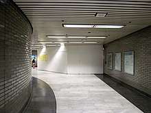
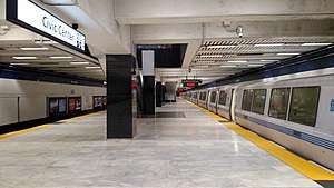
Like the three other shared BART/Muni stations in the Market Street Subway, Civic Center station has three levels: a fare mezzanine on the first level, an island platform for Muni Metro on the second level, and an island platform for BART on the third level. As with the other three stations, Civic Center was built with six entrances – three on each side of Market Street – leading to the fare concourse. A passageway to two additional entrances west of 8th Street and Hyde Street was opened later.[6] One of those entrances, on the north side of Market Street, was temporarily closed in December 2016 after a sewer pipe collapsed under the escalators.[7]
In August 2017, BART announced that both entrances would likely be permanently closed, as the passageway space is needed for a new electrical substation to increase Transbay Tube train frequency. The six original entrances (all of which are significantly closer to the faregates) will remain open.[8] The concourse has two BART fare payment areas and two Muni fare payment areas.[6]
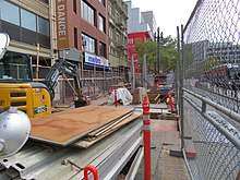
Following the 2015 addition of a canopy over an escalator at 19th Street Oakland station, which reduced escalator downtime by one-third, BART decided to add canopies to all downtown Oakland and San Francisco entrances.[9] The canopies will protect the escalator from weather damage, improve lighting, allow the escalator to be fully closed off when the station is not open, and provide a location for real-time train arrival information displays. The Civic Center station entrance at Market and 7th was chosen for early implementation; it was closed on December 11, 2017, with an expected construction time of seven months. The remaining station entrances will have similar canopies added beginning in 2019.[9]
In May 2018, BART proposed to close off a corridor that connects the 7th Street and 8th Street sides of the station because it was frequently used for drug use.[10]
See also
References
- ↑ Callwell, Robert (September 1999). "Transit in San Francisco: A Selected Chronology, 1850-1995" (PDF). San Francisco Municipal Railway. p. 57.
- ↑ "Monthly Ridership Reports". Bay Area Rapid Transit District. Retrieved February 6, 2017.
- ↑ "BART Chronology January 1947 – March 2009" (PDF). San Francisco Bay Area Rapid Transit District. March 2009. Archived from the original (PDF) on October 13, 2013.
- ↑ Cabanatuan, Michael (April 29, 2013). "BART station names growing unwieldy". San Francisco Chronicle. Retrieved February 26, 2018.
- 1 2 "CIVIC CENTER/U.N. PLAZA" (PDF). San Francisco Bay Area Rapid Transit District.
- 1 2 "Civic Center/UN Plaza Station map". San Francisco Bay Area Rapid Transit District. Archived from the original on March 3, 2014.
- ↑ "Civic Center Grove Street entrance closed for repairs" (Press release). San Francisco Bay Area Rapid Transit District. December 6, 2016.
- ↑ "Permanent entrance closures planned at Civic Center for traction power project" (Press release). San Francisco Bay Area Rapid Transit District. August 22, 2017.
- 1 2 "SF BART and Muni Escalator/Entrance Project". San Francisco Bay Area Rapid Transit District. Archived from the original on May 19, 2018.
- ↑ Turner, Emily (May 21, 2018). "BART Proposes Closing Walkway Favored By Drug Users At Civic Center Station". CBS SF BayArea.
External links
![]()
| Current lines |
| ||||||||||||
|---|---|---|---|---|---|---|---|---|---|---|---|---|---|
| Stations |
| ||||||||||||
| Infrastructure | |||||||||||||
| History | |||||||||||||
| General Managers |
| ||||||||||||
| Connecting services |
| ||||||||||||
| Other | |||||||||||||
| Buildings and business |
|
|---|---|
| Geography | |
| Public art | |
| Transportation | |
| |
| Muni Metro | |||||||
|---|---|---|---|---|---|---|---|
| Muni Metro system features | |||||||
| Heritage streetcar services | |||||||
| Other Muni services | |||||||
| Projects |
| ||||||
| Connecting services | |||||||
| Miscellaneous |
| ||||||
| |||||||||||||||||||||
| |||||||||||||||||||||
| |||||||||||||||||||||
| |||||||||||||||||||||
| |||||||||||||||||||||
| |||||||||||||||||||||
| |||||||||||||||||||||
| |||||||||||||||||||||