Butler Road station
Butler Road was a train station in South San Francisco, California, in operation until July 1983[1] on the Peninsula Commute, a commuter rail service run by Southern Pacific between San Francisco and communities on the San Francisco Peninsula. The Butler Road train shelter was built in 1926.[2]
 |
| Transportation in South San Francisco 1 2 3 4 |
History
The stop was next to the Shaw-Batcher steel mill, which opened in 1913; the mill was purchased by the Western Pipe and Steel Company in 1917.[3] 200 acres (81 ha) of land were acquired for a shipyard in August 1917,[4] and Shaw-Batcher was awarded a $30 million contract to build 18 merchant ships during World War I. The worksite population grew from 200 in early 1917 to 4,447 by July 1918, a month after the company's first ship was launched.[5] After the war, Western Pipe moved shipbuilding operations to San Pedro[6][7] and continued to produce pipe in South San Francisco, which was used in notable dam projects such as Hetch Hetchy, Grand Coulee, Shasta, and Folsom.[8] The shipyard was reactivated in 1939 for World War II,[9][10] and after the war ended, the site was sold in 1948 to Consolidated Steel (later United States Steel and its divisions),[11] which closed the mill in 1983.[11] Service to the Butler Road stop was also discontinued that year.[12]
The Butler Road stop was relatively little-used for much of its existence. In 1958, for example, only four of the 27 total northbound weekday commuter trains stopped at the station.[13] In 1978, only three of the 22 total northbound weekday trains stopped there.[14]
Butler Road, the road itself, has been renamed Oyster Point Boulevard.[15] The Peninsula Commute service was taken over by the State of California and renamed Caltrain in 1985, the name by which it is still known.
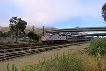
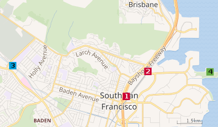
The Butler Road station was located between the still-operational Bayshore and South San Francisco stations.
Coordinates: 37°39′46″N 122°23′54″W / 37.66278°N 122.39833°W
References
- ↑ "Caltrans". National Railway Bulletin. Vol. 53–54. 1988. p. 38. Retrieved 2013-04-04.
- ↑ Janet McGovern (2012). Caltrain and the Peninsula Commute Service. Arcadia Publishing. p. 49. ISBN 978-0-7385-7622-0. Retrieved 2013-04-04.
- ↑ "Industry: Shaw Batcher Company, shipyards during World War I." flickr. South San Francisco Public Library. 1918. Retrieved 23 May 2018.
- ↑ "Big Ship Yard Soon for San Francisco". Sausalito News. 33 (35). 1 September 1917. Retrieved 24 May 2018.
- ↑ "For Peninsulans World War I was close to home struggle". San Jose Mercury News. 10 April 2009. Retrieved 23 May 2018.
- ↑ "S.F. Shipyards of Shaw-Batcher Co. May Close Down". San Pedro Daily News. XIX (135). 12 June 1920. Retrieved 24 May 2018.
- ↑ "Schwab Enters Shipbuilding Field Here". San Pedro Daily News. XIX (49). 24 March 1921. Retrieved 24 May 2018.
- ↑ Gustaitis, Rasa, ed. (2012). San Francisco Bay Shoreline Guide. Berkeley, California: University of California Press. p. 36. ISBN 978-0-520-27436-5. Retrieved 23 May 2018.
- ↑ "Western Pipe & Steel Co., South San Francisco CA and San Pedro CA". Shipbuilding History. 20 January 2014. Retrieved 23 May 2018.
- ↑ "S.S.F. Gets $10,000,000 Ship Job". The Times. San Mateo, California. 15 September 1939. Retrieved 23 May 2018. (subscription required)
- 1 2 "Bits of History: Exploring San Mateo County Historical Photographs". Retrieved 2013-04-04.
- ↑ Rail Passenger Development Plan, 1988-93 Fiscal Years (Report). Department of Transportation, State of California. March 1988. pp. 88, 122. Retrieved 24 May 2018.
- ↑ Jafafa Hots (Flickr member). "1958 San Francisco - San Jose Southern Pacific Passenger Time Tables Back". Retrieved 2013-04-04.
- ↑ Railsaroundthebay.net. "1978 Southern Pacific Timetable photo". Archived from the original on July 1, 2007. Retrieved 2013-04-04.
- ↑ South San Francisco Historical Society (2004). "South San Francisco (Images of America)". Arcadia Publishing. p. 4. ISBN 0-7385-2921-4. Retrieved 2013-04-04.
External links
- Butler Road on a 1978 Peninsula Commute timetable
- "Eastern South San Francisco. View north from Bethlehem Steel Company". Bits of History. Peninsula Library System. 1945. Retrieved 24 May 2018. This photograph shows the train line (from the lower left corner), Butler Road (running from lower left to lower right), and the Western Pipe factory.
- "South San Francisco during WW I". Bits of History. Peninsula Library System. Retrieved 24 May 2018.
San Bruno Road (later Airport Boulevard), Bayshore Highway, Butler Road (later Oyster Point Road), and Division Avenue (later Dubuque Ave.) during World War I, South San Francisco, CA.
| Stations |
| |
|---|---|---|
| Connecting services | ||
| Management | ||
| History | ||
| Projects |
| |
| Miscellaneous | ||
Category | ||