M Ocean View

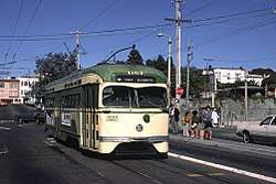
The M Ocean View is a Muni Metro light rail line in San Francisco, California. It was one of San Francisco's streetcar lines in the early 20th century.
History
The M Ocean View line began operation in 1925[2] with the outbound terminus at the intersection of Broad Street and Plymouth Avenue in the city's Ocean View District, where streetcars used a wye to turn around. Service along this route was replaced by buses in 1939, but rail service was shortly restored in 1944.[2] While many streetcar lines were permanently converted to buses after World War II, the M Ocean View remained a streetcar line due to its use of the Twin Peaks Tunnel. Service was diverted to Duboce Avenue, Church Street, and 17th Street on December 2, 1972 due to constriction of the Market Street Subway.[3] On August 30, 1980, the line was extended to Balboa Park BART station.[4] The full line was partially converted to modern light-rail operation with the opening of the Muni Metro system on December 17, 1980.[3] Eureka Valley in the Twin Peaks Tunnel was originally a stop in regular service, but the station was closed in 1972 and replaced, ten years later, by Castro Street Station when the Market Street Subway system opened.
In the early 1970s, Muni began planning an extension of the J Church line over new track to Balboa Park station, then over the M Ocean View line to the high-ridership San Francisco State University station and Stonestown Galleria station. A Final Environmental Impact Statement for the new track was released in 1983; it was opened for non-revenue moves in August 1991 and began revenue service in June 1993.[5][6] Original plans called for the two existing stations to be rebuilt with high-level platforms, and a pocket track to allow J Church trains to turn back. After objections from neighbors, the pocket track was removed from the plan.[6]
The first phase of the 19th Ave. Platform & Trackway Improvement Project required the line to replaced by buses south of St. Francis Circle from June 19 to October 23, 1993; the new platforms at the two stations were opened when service was restored, though several minor stops along 19th Avenue were left permanently closed.[6] The second phase required full bustitution beginning on July 30, 1994; rail service was restored to Stonestown on November 19 for holiday shopping, and on the rest of the line on January 28, 1995.[6] Some weekday J and M service was through-routed beginning on March 27, 1995; this lasted until a rail replacement project on the M in February 1998. Full combined J/M service was planned upon completion of the automated train control system and the Muni Metro Turnback; however, this was never implemented even after the construction projects were finished.[6]
In 2010, Muni replaced the rail junction just south of St. Francis Circle station. Rail service south of West Portal station was replaced with buses from May 17 to September 4.[7][8]
The line was temporarily replaced by buses from June 25 to August 24, 2018 due to the Twin Peaks Tunnel shutdown.[9]
Route description
The line runs from the Embarcadero Station in the Financial District to Geneva Avenue and San Jose Avenue near City College of San Francisco in the Balboa Park neighborhood. The downtown portion of the line runs through the Market Street Subway, which it shares with the four other Muni Metro lines. It continues through the much older Twin Peaks Tunnel, along with the K Ingleside and L Taraval lines, emerging at West Portal Station. From there, it follows West Portal Avenue to the Saint Francis Circle, where it then takes its own right-of-way to 19th Avenue. The portion of the line on 19th Avenue between where it joins 19th near Eucalyptus Drive and Junipero Serra Boulevard is a right-of-way separated from the street. This section has two stations with high-platforms, one at the Stonestown Galleria on Winston Drive and the other at San Francisco State University on Holloway Avenue. It continues on 19th Avenue past Junipero Serra to Randolph Street. At the end of Randolph, the M uses Orizaba Avenue to get to Broad Street and takes that to San Jose Avenue. The rest of the line follows San Jose Avenue to Geneva Avenue, where the line loops around the Metro yard there on the corner opposite from Balboa Park Station.

The M Ocean View line stops at large stations for the downtown section of the route and on 19th Avenue and at smaller stops on the rest of the line. Most of the smaller stops are nothing more than a sign on the side of the street designating a stop and a few others are concrete 'islands' in the middle of the street next to the tracks that provide access for wheelchairs. Muni bus routes provide service to all stations and other systems with access to the stations are noted.
19th Avenue Transit Study
19th Avenue/ M Ocean View Project | ||||||||||||||||||||||||||||||||||||||||||||||||||||||||||||||||||||||||||||||||||||||||||||||||||||||||||||||||||||||||||||||||||||||||||||||||||||||||||||||||||||||||||||||||||
|---|---|---|---|---|---|---|---|---|---|---|---|---|---|---|---|---|---|---|---|---|---|---|---|---|---|---|---|---|---|---|---|---|---|---|---|---|---|---|---|---|---|---|---|---|---|---|---|---|---|---|---|---|---|---|---|---|---|---|---|---|---|---|---|---|---|---|---|---|---|---|---|---|---|---|---|---|---|---|---|---|---|---|---|---|---|---|---|---|---|---|---|---|---|---|---|---|---|---|---|---|---|---|---|---|---|---|---|---|---|---|---|---|---|---|---|---|---|---|---|---|---|---|---|---|---|---|---|---|---|---|---|---|---|---|---|---|---|---|---|---|---|---|---|---|---|---|---|---|---|---|---|---|---|---|---|---|---|---|---|---|---|---|---|---|---|---|---|---|---|---|---|---|---|---|---|---|---|---|
| ||||||||||||||||||||||||||||||||||||||||||||||||||||||||||||||||||||||||||||||||||||||||||||||||||||||||||||||||||||||||||||||||||||||||||||||||||||||||||||||||||||||||||||||||||
M Ocean View moves at only 8.5 to 9.5 miles per hour (13.7 to 15.3 km/h) during afternoon commute hours over a 2-mile (3.2 km) distance along 19th Avenue/Highway 1. The slow speed is attributed to trains stopping at multiple busy street crossings.[10] In addition, the majority of riders access 19th Avenue stops from the west side of 19th, since Stonestown Galleria, San Francisco State University and Parkmerced are all located west of 19th. In order to access the stops, which are located in the median of 19th Avenue, pedestrians cross three lanes of traffic and a turn lane. In San Francisco, 55% of severe and fatal pedestrian accidents occur on 7% of its street miles, which includes the 19th Avenue/Highway 1 corridor.[11] In response, the San Francisco County Transportation Authority commissioned a study, published in 2014 to explore options to facilitate pedestrian access and improve travel times.
The option that has been selected is the full subway alternative. The M Ocean View and K Ingleside will remain underground along West Portal Avenue. The current West Portal station will most likely have to be redesigned as a two-level station with the K and M lines on the lower level and the L line on the upper level. The K/M lines will remain underground through Saint Francis Circle with the K line branching off and coming to the surface on Junipero Serra Boulevard just south of Saint Francis Circle. The M line will remain underground along the current right of way with a possible station at Ocean Avenue in Lakeside Village. The M line will continue underground with new subway stations at Stonestown, SF State, and Parkmerced. The line will end at Parkmerced with a long tail track which may connect to a future Daly City BART extension of the M line. The cost of this project is expected to be approximately $3 billion.[12]
Operation
The M Ocean View begins service at 5 a.m. weekdays, 6 a.m. Saturdays and 8 a.m. Sundays, with the end of service occurring around 12:30 a.m. each night. It operates a headway of 9 to 12 minutes during the day, and 15 to 20 minutes at night. There is no late night service along the entire M line, however part of the L-Owl diesel bus line runs from West Portal Station to Market Street and Steuart Street, near Embarcadero Station, and the 91 Owl line operates on 19th Avenue. On Sunday mornings only, there is a M-Owl diesel bus line that runs on surface streets from Market Street and Steuart Street to Balboa Park between the times owl service stops and the underground subway stations open.
Station and stop listing
inbound to outbound
| Station | Neighborhood | Other Muni Metro lines |
Notes |
|---|---|---|---|
| Financial District | Inbound terminus Connects to F Market & Wharves and BART Serves Ferry Building | ||
| Financial District | Connects to F Market & Wharves and BART | ||
| Financial District | Connects to F Market & Wharves and BART | ||
| Civic Center | Connects to F Market & Wharves and BART | ||
| Civic Center and Tenderloin | Connects to F Market & Wharves | ||
| Duboce Triangle | *Connects with J Church on surface stop at 14th Street Connects with F Market & Wharves streetcar | ||
| Castro | |||
| Forest Hill and Laguna Honda | |||
| West Portal | |||
| West Portal and 14th Avenue | West Portal | ||
| St. Francis Wood | |||
| Ocean | Merced Manor | right-of-way | |
| Eucalyptus | Merced Manor | right-of-way | |
| Parkmerced | Intersection of 19th and Winston serves Stonestown Galleria | ||
| Parkmerced | Intersection of 19th and Holloway serves nearby SFSU | ||
| 19th Avenue and Junipero Serra | Merced Heights | ||
| Randolph and 19th Avenue | Merced Heights | ||
| Merced Heights | |||
| Randolph and Bright | Ingleside | ||
| Broad and Orizaba | Ingleside | ||
| Broad and Capitol | Ingleside | ||
| Ingleside | |||
| San Jose and Farallones | Ingleside | ||
| San Jose and Lakeview | Ingleside | ||
| San Jose and Mount Vernon | Ingleside | ||
| San Jose and Niagara (outbound) | Ingleside | Outbound terminus Within walking distance of the Balboa Park station complex, with transfer to BART, J Church, and K Ingleside available |
References
- ↑ "TEP Route Data & Proposed Changes". San Francisco Municipal Transportation Agency (SFMTA). 2013. Retrieved 2013-12-15.
- 1 2 3 Demery, Jr., Leroy W. (November 2011). "U.S. Urban Rail Transit Lines Opened From 1980" (PDF). publictransit.us. Archived from the original (pdf) on November 4, 2013. Retrieved November 2, 2013.
- 1 2 Callwell, Robert (September 1999). "Transit in San Francisco: A Selected Chronology, 1850-1995" (PDF). San Francisco Municipal Railway.
- ↑ McKane, John; Perles, Anthony (1982). Inside Muni: The Properties and Operations of the Municipal Railway of San Francisco. Glendale, CA (US): Interurban Press. p. 198. ISBN 0-916374-49-1.
- ↑ Muni J Line Connection Project Final Environmental Impact Statement. Urban Mass Transit Administration and San Francisco Department of City Planning. May 1983 – via Internet Archive.
- 1 2 3 4 5 Callwell, Robert (September 1999). "Transit in San Francisco: A Selected Chronology, 1850-1995" (PDF). San Francisco Municipal Railway. pp. 76–79.
- ↑ "SFMTA Announces Details of St. Francis Circle Project to Begin in May" (Press release). San Francisco Municipal Transportation Agency. April 29, 2010.
- ↑ "SFMTA Prepares to Restore 61 Percent of Muni May 8 Service Cuts and Completes St. Francis Circle Project" (Press release). San Francisco Municipal Transportation Agency. September 2, 2010.
- ↑ "Twin Peaks Tunnel Improvements". San Francisco Municipal Transportation Agency. June 25, 2018. Archived from the original on June 26, 2018.
- ↑ 19th Avenue Transit Study (PDF) (Report). San Francisco County Transportation Authority. March 2014. Archived (PDF) from the original on 2 April 2015. Retrieved 22 March 2016.
- ↑ WalkFirst: Improving Safety & Walking Conditions in San Francisco (PDF) (Report). San Francisco Department of Public Health. October 2011. Retrieved 22 March 2016.
4.3 HIGH-INJURY DENSITY CORRIDORS
The identified corridors shown in blue in Map 3 represent 6.7% of San Francisco's street miles, and include 55% of all severe and fatal injuries and 51% of total pedestrian injuries in the five-year period. - ↑ https://www.sfmta.com/sites/default/files/projects/2016/Station%202%20Rail.pdf
External links
- Muni Metro and San Francisco rail map (195KB PDF)
- M Ocean View route information from the SF Muni Map Project
| Muni Metro | |||||||
|---|---|---|---|---|---|---|---|
| Muni Metro system features | |||||||
| Heritage streetcar services | |||||||
| Other Muni services | |||||||
| Projects |
| ||||||
| Connecting services | |||||||
| Miscellaneous |
| ||||||