City of David
| Part of a series on |
| Jerusalem |
|---|
-Aerial-Jerusalem-Temple_Mount-Temple_Mount_(south_exposure).jpg) |
| Sieges |
| Places |
| Positions |
| Other topics |
|
|
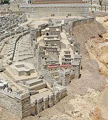
The City of David (Hebrew: עיר דוד, Ir David; literal translation to Arabic: مدينة داوود, Madina Dawud, common Arabic name: وادي حلوه, Wadi Hilweh) is an Israeli settlement and the archaeological site which is speculated to compose the original urban core of ancient Jerusalem.[1][2][3][4][5] First suggested in 1920, the name was used officially from the 1970s, following the capture of East Jerusalem by Israel, but today the name is questioned in the archaeological academic community.[1] In 1997 management of the park was taken over by Ir David Foundation.[1] Although it is located within the Jerusalem Municipality, it is considered a settlement,[6][7][8][9] having been built on land in the West Bank that was occupied by and annexed to Israel following the 1967 Six-Day War and 1980 Jerusalem Law. The international community regards Israeli settlements illegal under international law, although Israel disputes this. It is best known for its Iron Age structures attributed to Judean kings, and it also contains older Canaanite infrastructure dated to the Middle Bronze Age.
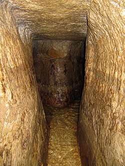
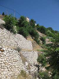
The site is now located under the Arab neighborhood of Wadi Hilweh, and extends down from the southern city walls of Jerusalem's Old City. The remains at the site include several water tunnels, one of which was built by King Hezekiah and still carries water, several pools including the Pool of Siloam known from the Old and New Testaments, and here or at the adjacent Ophel scholars expect to find, or claim to have found, the remains of the Acra,[10] a fortress built by Antiochus Epiphanes to subdue those Jerusalemites who were opposed to Hellenisation. City of David archaeologist Eilat Mazar believes that a so-called Large Stone Structure she has discovered at the upper area of the site and tentatively dated to the tenth to ninth century BC, may be the palace of King David.[11] Not far from that excavation area a number of bullae (seal impressions) were unearthed, bearing the names of Yehucal son of Shelemiah and Gedaliah son of Pashhur, two officials mentioned in the Book of Jeremiah.
The area is one of the most intensively excavated sites in the Holy Land.[12]
The debate within biblical archaeology over the location of the City of David began in the late 19th century with the excavations of Charles Warren and Hermann Guthe on the hill southeast of the Old City.[13][14] The 1909–11 work of Louis-Hugues Vincent and Montagu Brownlow Parker identified the earliest known settlement traces in the Jerusalem region,[15][16] suggesting the area was an ancient core of settlement in Jerusalem dating back to the Bronze Age.[17][18] It is on a narrow ridge running south from the Temple Mount in the predominantly Arab neighborhood of Wadi Hilweh, which is part of Silwan, an East Jerusalem suburb.[19][20] It is thought to have been a walled city in the Bronze Age which enjoyed the defensive advantages of its position, as it is almost surrounded by the Central or Tyropoeon Valley to its west, by the Hinnom Valley to the south, and the Kidron Valley on the east. In the pre-Israelite period, the area is thought to have been separated from the site of the later Temple Mount by the Ophel, an uninhabited area which became the seat of government under Israelite rule.[21] During the reign of Hezekiah, the walls of Jerusalem were expanded westward, across the Central Valley from the City of David and the Temple Mount, enclosing a previously unwalled suburb in the area known today as the Western Hill of the Old City.
The City of David/Wadi Hilweh is highly controversial in the context of the Israeli–Palestinian conflict. In 2018, a leaked report by the European Economic Community cited the area as one being developed for tourism to justify settlements and insist on Jewish heritage at the expense of its Palestinian context.[22]
Main archaeological sites
- The Gihon Spring, which lies on the eastern slope of the southeastern hill of Jerusalem aka the City of David, and is generally considered the very reason why the city first emerged at this specific location.[21]
The ancient water systems connected to the Gihon Spring[21] include natural, masonry-built, and rock-cut structures, such as
- The Spring Tower
- Warren's Shaft, a natural shaft, once thought to have been a water supply system
- The Siloam Channel, a water system that preceded the Siloam Tunnel
- The Siloam Tunnel, a water supply system where the Siloam inscription was found
- The Siloam Pool - two connected pools, an upper one from the Byzantine era, and the recently discovered, lower Second Temple-period pool.
Other built structures, spread over excavated sections known as Area A, B, C, ... include
- The Large Stone Structure
- The Stepped Stone Structure
- City walls and towers, houses, a columbarium, rock-cut vaulted tunnels once interpreted as royal Judahite tombs, a rock-cut pool where the Theodotus Inscription was discovered etc.
- A monumental stepped street probably used by Second Temple-period pilgrims and built over a large
- drainage system.
An adjacent and related excavation site is known as the
History of exploration
Archaeological exploration of the area began in the nineteenth century, with excavations undertaken by Charles Warren in 1867. Warren was sent by the Palestine Exploration Fund. Warren conducted an excavation of the area south of the Temple Mount and recovered a massive fortification. The finding led him to conduct more excavations at the area south of the Temple Mount. There he revealed a vertical shaft descending from a slanted underground tunnel to an spparent water source. He suggested that the shaft was used to supply water to the city, which he believed was the old biblical city of David. Today this shaft is called after its discoverer "Warren's shaft", but his interpretation has been proven wrong, as the shaft is not man-made and had not yet been discovered by Jerusalem's inhabitants in the 10th century BCE.
There have been numerous excavations since and several digs are currently underway. Complete chronological lists of the digs are available at the website of the Israel Antiquities Authority, dating to following periods:
Archaeological periods
Chalcolithic (4500–3500 BCE)
Chalcolithic remains include bits of pottery found in clefts in the bedrock by Macalister and Duncan.[27] The expedition also discovered a number of places where the bedrock had been cut in various ways. These included areas where the rock had been smoothed and others where it had been cut to form flow channels. There were also several groups of small basins, sometimes called cup marks, cut into the bedrock. These are assumed to have been used for some form of agricultural processing. Macalister and Duncan speculated that they were used in olive oil processing.[27] Edwin C. M. van den Brink, who notes that similar carved basins have been found at Beit Shemesh and near Modi'in-Maccabim-Re'ut speculates that they may have been created by repeated grinding and crushing activity, such as the grinding of grain or the crushing of olives.[28] Eilat Mazar speculates that they were used to collect rainwater.[21]
Early Bronze Age (3500–2350 BCE)
Pieces of pottery have been found.
Middle Bronze Age (2000–1550 BCE)
Middle Bronze Age Jerusalem is mentioned several times in Egyptian texts from the 19th–18th centuries BCE.[29] A town called Shalem is mentioned in this era in the biblical story of Melchizedek (Genesis 14:18–20), which may have been Jerusalem.
Late Bronze Age (1550–1200 BCE)
Pottery and bronze arrowheads dating form this period have been found.[21]
In 2010, a fragment of a clay tablet dating from the 14th century BCE was uncovered, making it the oldest written document yet uncovered in Jerusalem. It is dated by the writing it bears, in an ancient Akkadian cuneiform script. The text was deciphered by graduate student Takayoshi Oshima working under professor Wayne Horowitz. According to Horowitz, the quality of the writing indicates that this was a royal inscription, apparently a letter from the king of Jerusalem to the pharaoh in Egypt.[30] Professor Christopher Rollston points out that there is no mention of any personal names or titles and no place names in the document. He notes that the quality of the script is good but that this does not show that it is "international royal correspondence." He also suggests that caution should be taken before positing a definite date as it is not a stratified find, having been discovered after excavation in a 'wet sieving' process.[31]
Iron Age I (1200–980/70 BCE)
The Bible says Jerusalem was a Jebusite city, which was captured by troops under King David. The biblical description is very brief (2 Samuel 5:6–8 and 1 Chronicles 114–116), leaving space for speculation about how exactly the town was conquered, also due to the lost meaning of the ancient Hebrew word "tzinor". It is inferred from I Kings 11:27 that he breached the walls, and if the "tzinor" II Samuel 5:8 is understood as 'water shaft', then Joab climbed up first into the city by using the ancient water system at the Gihon Spring. The Bible then says that the Israelites continued to use the Jebusite walls, repairing them where needed, and extended the city northward, under King Solomon, to include the Temple Mount (I Kings 9:15).
Iron Age IIa (1000–900 BCE)

The period of the tenth and ninth centuries BCE has been the subject of an intense scholarly dispute, as well as of ongoing archaeological investigations.[32]
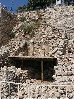
The 2005 discovery by archaeologist Eilat Mazar of a Large Stone Structure, which she dated to the tenth century BCE, would be evidence of buildings in Jerusalem of a size appropriate to the capital of a centralized kingdom at that time. Others, most notably Israel Finkelstein of Tel Aviv University, argue that the structure could, for the most part, be from the much later Hasmonean period.[33] However, new evidence continues to emerge from the dig. Mazar's date is supported by 10th century imported luxury goods found within the Large Stone Structure, including two Phoenician-style ivory inlays once attached to iron objects. Comparable objects found in a Phoenician tomb at Achziv suggest that they may have decorated a sword handle.[34] A quantity of luxury round, carinated bowls with red slip and hand burnishing support both the tenth century date and a sophisticated, urban lifestyle.[35] A bone has been radiocarbon dated by Elisabetta Boaretto at the Weizmann Institute, showing a probable date between 1050 and 780 BCE.[35] A large section of a "delicate and elegant" black-on-red jug, also found in the structure, is of a kind dated to the second half of the tenth century BCE.[36][37]
In 2010 Mazar announced the discovery of what she believed to be a 10th-century BCE city wall. According to Mazar, "It's the most significant construction we have from First Temple days in Israel," and "It means that at that time, the 10th century, in Jerusalem there was a regime capable of carrying out such construction." Aren Maeir, an archeology professor at Bar Ilan University, said he has yet to see evidence that the fortifications are as old as Mazar claims.[38] Doron Ben-Ami wrote in 2014 that, on the basis of his own excavations, there was no 10th century wall where Mazar claimed: "Had a fortified settlement existed in the City of David, then the course of the city wall on the west would have had to pass through the Givati excavation area. No such city wall has thus far been found. This means that the Iron IIA settlement was not fortified. It also means that the fortified city of the Iron IIB, which encompassed both the City of David and the Western Hill, had no need for a fortification line between these two sectors of the city.[39]
Necropolis

The elaborate rock-cut tombs of the Israelite period, dating from the 9th to the 7th centuries BCE, are found on the ridge on the eastern side of the Kidron Valley in and under the Arab village of Silwan.[40] These are large, elaborate tombs of skilfully cut into the stone face of the eastern slope, such as could only have been built by the highest-ranking members of a wealthy society. According to David Ussishkin, "here ministers, nobles and notables of the kingdom of Judah were buried."[40]
The architecture of the tombs and the manner of burial is different "from anything known from contemporary Palestine. Elements such as entrances located high above the surface, gabled ceilings, straight ceilings with a cornice,13 trough-shaped resting-places with pillows, above-ground tombs, and inscriptions engraved on the facade appear only here."[40] However, the stone benches were carved with headrests in a style borrowed from the Egyptian Hathor wig.[41] Ussishkin believes that the architectural similarity to building styles of the Phoenician cities validates the biblical description of Phoenician influence on the Israelite kingdoms, but speculates that some or all of the tombs may have been built by Phoenician aristocrats living in Jerusalem.[40]
Although only three partial inscriptions survive, the paleography makes the dating certain [40] and they suffice for most archaeologists to identify one tomb with the Biblical Shebna, steward and treasurer of King Hezekiah.[42]
Iron Age IIIb (8th century – 586 BCE)
This is the period that corresponds to the biblical Kings Hezekiah through Josiah and the destruction of the Kingdom of Judah by Nebuchadnezzar II.
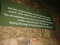
King Hezekiah secured the city's water supply against siege by digging the Siloam Tunnel through bedrock and covering over all signs of the Gihon Spring and the fortifications that had surrounded it in earlier periods. He built the Pool of Siloam as a water reservoir. Hezekiah then surrounded the new reservoir and the city's burgeoning western suburbs with a new city wall.[43][44]
Bullae with the names of Yehucal son of Shelemiah and Gedaliah son of Pashhur, two officials mentioned in the Book of Jeremiah, have been found.
Babylonian and Persian periods (586–322 BCE)
Two bullae in the neo-Babylonian style, one showing a priest standing beside an altar to the gods Marduk and Nabu.[45] A polished, black, stone Scaraboid seal showing a "Babylonian cultic scene" of two bearded men standing on each side of an altar dedicated to the Babylonian moon god Sin. The scaraboid is understood to have been produced in Babylonia, with space left below that altar for a personal name. In that space are Hebrew letters that Peter van der Veen has read as the name Shelomit.[46]
Hasmonean and Herodian periods (167 BCE – 70 CE)

Major archaeological finds include the Pool of Siloam, the Jerusalem pilgrim road, the palace of Queen Helena of Adiabene and the Jerusalem Water Channel. Active Roman-era excavations are also underway at the Givati Parking Lot dig site.[47]
Byzantine and early Islamic Periods (324–1099 CE)
Byzantine era mansion called the House of Eusebius.[48]
During the Givati Parking Lot dig a hoard of 264 gold coins was found from the time of Emperor Heraclius (7th century AD).
Modern period

Mid-19th century photographs taken by Scotsman James Graham (1853–57) show the City of David ridge as being devoid of housing. It is terraced and planted, apparently, with olive trees.[49]
Modern settlement began in 1873–1874, when the Meyuchas family, a Jewish rabbinical and merchant family that had lived in Jerusalem since their expulsion from Spain, moved a short distance outside the city walls to a house on the ridge.[50] During the latter stages of the Mandate era the houses of the nearby Arab village of Silwan expanded across the Kidron Valley and up the ridge as well. After the 1948 Arab–Israeli War, the whole area fell on the eastern side of the Green Line under Jordanian control and its Jewish population was expelled. Arab families continued to live on the ridge and to build houses there after 1967. From 1968 to 1977 the Israel Exploration Society started the first excavations at the Ophel, north of the City of David proper, headed by Benjamin Mazar and Eilat Mazar.[51]
Controversy
The right to control both the archaeological and the residential aspects of the City of David is hotly contested by Israelis and Palestinians.[52] There is a proposal to turn most of the area into an archaeological park,[53] and to transform a part of the Kidron Valley currently inhabited by Arabs into a park to be called the King's Garden.[54]
The City of David is highly controversial in the context of the Israeli–Palestinian conflict.[55][56][57] It is located in Wadi Hilweh, on the western ridge of the predominately Arab neighborhood of Silwan. Jews constitute the majority of the population. In October 2014, Uri Ariel, politician from The Jewish Home party and at that time Israeli Minister of Housing and Construction, caused controversy when he suggested he was considering taking up residence in the area.[58] The construction of the 16,000 m2 Kedem Compound, approved in April 2014,[59] was denounced by UNESCO in October 2016.[60]
Tourism
The entire site, including the Gihon Spring and the two Pools of Siloam, is incorporated in an archaeological park open to the public. Visitors can wade through the Siloam Tunnel, through which the waters of the ancient spring still flow,[61] although the change in the water table in recent times mean that the once intermittent karstic spring is now artificially maintained through pumping.
See also
Sites adjacent to the City of David:
- Acra (fortress)
- Ancient city walls around the City of David, actually north of it, where it borders the Ophel
- Givati Parking Lot dig
- Ophel, the saddle between the Temple Mount and the City of David
Other related topics:
- Excavations at the Temple Mount
- First Temple, aka "Solomon's Temple"
- Silwan, East Jerusalem suburb containing the City of David
- Tel Motza temple, contemporary with the First Temple
References
- 1 2 3 Wendy Pullan; Maximilian Sternberg; Lefkos Kyriacou; Craig Larkin; Michael Dumper (20 November 2013). "David's City in Palestinian Silwan". The Struggle for Jerusalem's Holy Places. Routledge. p. 77. ISBN 978-1-317-97556-4.
However, right into the early twentieth century only the Virgin's Found (Ain Umm el-Daraj) and the Waters of Siloam (Ain Silwan) had any known historic or religious significance and the area had virtually no specific meaning for Judaism or local Jewish religious practice. In 1920, a French archaeologist first suggested renaming Wadi Hilweh 'La Cité de David', explicitly privileging this specific, speculative biblical tie as the narrative leitmotif of the successive exeavations, which have revealed extremely varied findings, both in type and chronological attributions. It was only in the 1970s, when a major Israeli excavation project was conducted, there that 'David's City' became the official Israeli designation, initially having no particular religious connotation, today, the term itself is increasingly questioned in the archaeological academic community. Since El'Ad took over the management of the park in 1997, 'David's City' has essentially become a religious-nationalist battle cry that has transformed the area from an ordinary Palestinian neighbourhood with a few excavation pits, largely unknown to the Israeli public, into a religious settlement and major national biblical monument with hundreds of thousands of visitors a year and an official education site for Israeli school children and soldiers.
- ↑
- ↑ Ariel, D. T., & De Groot, A. (1978). "The Iron Age extramural occupation at the City of David and additional observations on the Siloam Channel." Excavation at the City of David, 1985.
- ↑ Broshi, M. (1974). "The expansion of Jerusalem in the reigns of Hezekiah and Manasseh." Israel Exploration Journal, 21–26.
- ↑ Reich, R., & Shukron, E. (2000). "The Excavations at the Gihon Spring and Warren's Shaft System in the City of David." Ancient Jerusalem Revealed. Jerusalem, 327–339.
- ↑ Wendy Pullan and Max Gwiazda, Jerusalem's 'City of David': The Politicisation of Urban Heritage, Divided Cities/Contested States Working Paper No. 6, 2008, p.12: "The 'City of David' is formally treated as a settlement; making homes for Jewish people is seen as an integral part of El-Ad's heritage stewardship"
- ↑ B'Tselem, The Israeli Information Center for Human Rights in the Occupied Territories, List of Settlement in the West Bank, updated May 2015
- ↑ The Independent, "Israeli foreign ministry cadets to defend 'legality' of West Bank settlements", 1 November 2015, "Among the new sessions to be added to the cadet's course are a lecture on the legality of the settlements based on the claim that the West Bank is not occupied territory, according to The Times of Israel. It also includes a tour of the “City of David” settlement in the Palestinian Silwan neighbourhood of East Jerusalem, to be led by settler leader David Be'eri, who seeks its transformation, based on biblical claims, into a Jewish area."
- ↑ Sixty-ninth session of the United Nations General Assembly, Israeli settlements in the Occupied Palestinian Territory, including East Jerusalem, and the occupied Syrian Golan: Report by the Secretary-General, A/69/348, 25 August 2014: "Archaeological excavations and parks are also used as a way to control land for settlements, mainly through the funding, participation and endorsement by the Government of Israel of archaeological projects led by settler organizations. Observer organizations report that several archaeological projects in the Old City of Jerusalem are being used as a means to consolidate the presence of settlements and settlers in the area. On 3 April 2014, despite several objections presented by Palestinian residents of the Silwan neighbourhood, a Palestinian community with a population of 45,000, located around the southern Old City wall in East Jerusalem, the Jerusalem District Planning and Building Committee approved a project known as the Kedem Compound.36 The Kedem Compound includes a museum, a visitors centre, and a parking lot covering around 16,000 square metres. The plan was presented by Israel's Nature and Parks Authority and the Ir David Foundation, also known as Elad, which works to strengthen the Jewish connection to Jerusalem, notably the Silwan area. The Kedem Compound would constitute a gateway to the City of David National Park, a touristic archaeological site controlled by the same organization."
- ↑ Eisenbud, D. (2015). "Archeological find in Jerusalem's City of David may answer ancient mystery", Jerusalem Post.
- ↑ Mazar, Eilat, 2009, "The Palace of King David, Excavations at the Summit of the City of David. Preliminary Report of Seasons 2005–2007." Jerusalem
- ↑ Light at the End of the Tunnel: Warren's Shaft Theory of David's Conquest Shattered Archived 2014-08-01 at the Wayback Machine., Ronny Reich and Eli Shukron, BAR January/February 1999: 22–33, 72, quote: "The area we are talking about – the eastern slope of the City of David and particularly the strip above the Gihon Spring – has been subject to more archaeological excavations and research than any site in Jerusalem, and even in Israel."
- ↑ Excavations in the City of David Under Ottoman Rule Archived 2011-07-21 at the Wayback Machine., quote: "Warren and Guthe's discoveries triggered the discussion on whether it was this very hill, on the southern outskirts of the Old City of Jerusalem, which was taken by King David and turned into his capital."
- ↑ Palestine Exploration Fund 1895, including a number of scholarly discussions on the debate around the location
- ↑ Excavations in the City of David Under Ottoman Rule Archived 2011-07-21 at the Wayback Machine., quote: "One of the peculiar outcomes of this "dig" was that the ancient graves discovered on the upper part of the slope and correctly dated by Vincent to the Early Bronze period, are still the most ancient remains known, not only on the southeastern hill but in all of Jerusalem. This discovery has actually provided the decisive proof that the southeastern hill is the site of the earliest human settlement of Jerusalem and confirms its identification as the biblical City of David."
- ↑ The Oxford Companion to Archaeology, p.167
- ↑ Israel Finkelstein, Neil Asher Silberman, David and Solomon: In Search of the Bible's Sacred Kings and the Roots of Western Tradition Simon and Schuster, 2007 p.129.
- ↑ Hillel Geva, 'Western Jerusalem at the End of the First Temple Period in Light of the Excavations in the Jewish Quarters,' in Andrew G. Vaughn, Ann E. Killebrew (eds.), Jerusalem in Bible and Archaeology: The First Temple Period, Society of Biblical Literature, 2003, pp.183–208, p.183.
- ↑ Aviad Glickman, L-4167597,00.html 'Silwan man who stoned Jewish vehicle gets 4 years,' at Ynet 27 Dec 2011.
- ↑ United Nations, Report of the Human Rights Council: Twelfth Session (14 September - 2 October 2009 UN 2010 p.98 (j).
- 1 2 3 4 5 Mazar, Eilat, "Excavations at the Summit of the City of David, Preliminary Report of Seasons 2005–2007," Shoham, Jerusalem and New York, 2009, p. 21.
- ↑ Oliver Holmes, 'Israel using tourism to legitimise settlements, says EU report,' The Guardian 1 February 2018:'Archaeology and tourism development by government institutions as well as private settler organisations established what it said was a “narrative based on historic continuity of the Jewish presence in the area at the expense of other religions and cultures”. Chief among them, the report warned, was the City of David, a government-funded archeological park in the Palestinian neighbourhood of Silwan that provides tours in the ruins of ancient Jerusalem. The site is operated by a settler organisation “promoting an exclusively Jewish narrative, while detaching the place from its Palestinian surroundings”.
- ↑ https://web.archive.org/web/20110721143144/http://www.archpark.org.il/excavations1a.shtml
- ↑ https://web.archive.org/web/20110721143153/http://www.archpark.org.il/excavations1b.shtml
- ↑ https://web.archive.org/web/20110721143202/http://www.archpark.org.il/excavations1c.shtml
- ↑ https://web.archive.org/web/20110721143214/http://www.archpark.org.il/excavations1d.shtml
- 1 2 Macalister, R.A. and Duncan, J.G., Excavations on the hill of Ophel, Jerusalem, 1923-1925; being the joint expedition of the Palestine Exploration Fund and the 'Daily Telegraph', London, 1926.
- ↑ Edwin C. M. van den Brink, "A New Fossil Director of the Chalcolithic Landscape in the Shephelah and the Samarian and Judaean Hill Countries: Stationary Grinding Facilities in Bedrock", IEJ 58.1 (2008), pp.1-23.
- ↑ Mazar, Eilat, "Excavations at the Summit of the City of David, Preliminary Report of Seasons 2005–2007," Shoham, Jerusalem and New York, 2009, p. 23.
- ↑ "Oldest written document ever found in J'lem," Hartman, July 12, 2010, Jerusalem Post.
- ↑ Rollston, Christopher. "Rollston's Reflections on the Fragmentary Cuneiform Tablet from the Ophel: A Critique of the Proposed Historical Context". Retrieved 15 July 2010.
- ↑ Rachel Ginsberg (2009-06-29). "The world of archeology is rocked by evidence of King David's palace unearthed in Jerusalem". Aish.com. Retrieved 2009-06-29.
- ↑ Israel Finkelstein, Ze'ev Herzog, Lily Singer-Avitz and David Ussishkin (2007), Has King David's Palace in Jerusalem Been Found?, Tel Aviv: Journal of the Institute of Archaeology of Tel Aviv University, 34(2), 142-164
- ↑ Mazar, Eilat, Excavations at the Summit of the City of David, Preliminary Report of Seasons 2005-2007, Shoham, Jerusalem and New York, 2009, pp. 52-3.
- 1 2 Mazar, Eilat, Excavations at the Summit of the City of David, Preliminary Report of Seasons 2005-2007, Shoham, Jerusalem and New York, 2009, p. 52.
- ↑ Color photo in Mazar, Eilat, Excavations at the Summit of the City of David, Preliminary Report of Seasons 2005-2007, Shoham, Jerusalem and New York, 2009, p. 53.
- ↑ Herzog, H. and Sinver-Avitz, L., Redefining the Center: The Emergence of State in Judah, Tel Aviv, 31/2, 2004, pp. 209-44.
- ↑ Jerusalem city wall dates back to King Solomon, Jerusalem Post, Fe. 23, 2010,
- ↑ Doron Ben-Ami (2014). "Notes on the Iron IIA Settlement in Jerusalem in Light of Excavations in the Northwest of the City of David". Tel Aviv. 41 (1): 3–19.
- 1 2 3 4 5 The Necropolis from the Time of the Kingdom of Judah at Silwan, Jerusalem, David Ussishkin, The Biblical Archaeologist, Vol. 33, No. 2 (May, 1970), pp. 33-46,
- ↑ Joffe, Alexander, The Rise of Secondary States in the Iron Age Levant, Journal of the Economic and Social History of the Orient, Vol. 45, No. 4, 2002, pp. 425-467.
- ↑ "Ancient Jerusalem's Funerary Customs and Tombs: Part Two, L. Y. Rahmani, The Biblical Archaeologist, Vol. 44, No. 4 (Autumn, 1981), pp. 229-235.
- ↑ Jerusalem: an archaeological biography, Hershel Shanks, Random House, 1995, p. 80.
- ↑ Jewish Quarter Excavations in the Old City of Jerusalem: The finds from areas A, W and X-2 : final report Volume 2 of Jewish Quarter Excavations in the Old City of Jerusalem: Conducted by Nahman Avigad, 1969-1982, Nahman Avigad, Hillel Geva, Israel Exploration Society, 2000.
- ↑ Mazar, Eilat, Excavations at the Summit of the City of David, Preliminary Report of Seasons 2005-2007, Shoham, Jerusalem and New York, 2009, pp. 77-8.
- ↑ Mazar, Eilat, Excavations at the Summit of the City of David, Preliminary Report of Seasons 2005-2007, Shoham, Jerusalem and New York, 2009, pp. 78-9.
- ↑ "2,000 year-old cameo found in Jerusalem," Aug. 30, 2010, Jerusalem Post.
- ↑ Macalister, R.A. and Duncan, J.G., Excavations on the hill of Ophel, Jerusalem, 1923-1925 being the joint expedition of the Palestine Exploration Fund and the 'Daily Telegraph', London, 1926.
- ↑ Photos available in "Picturing Jerusalem, James Graham and Michael Diness, photographers", ed. Nissan N. Perez, Israel Museum, 2007. p. 31 and others.
- ↑ Yemin Moshe: The Story of a Jerusalem Neighborhood, Eliezer David Jaffe, Praeger, 1988, p. 51
- ↑ Excavations on the South of the Temple Mount. The Ophel of Biblical Jerusalem, Qedem. Monographs of the Institute of Archaeology, The Hebrew University of Jerusalem, No. 29, 1989 ISSN 0333-5844
- ↑ Ahdaf Soueif, The dig dividing Jerusalem, The Guardian, 26 May 2010
- ↑ "The Jerusalem Archaeological Park – about". www.archpark.org.il. Archived from the original on 2016-12-24. Retrieved 2016-08-01.
- ↑ Abe Selig, Gan Hamelech residents wary of Barkat's redevelopment plan, Feb. 16, 2010, Jerusalem Post. Accessed August 1, 2016
- ↑ Rapoport, Meron, Shady Dealings in Silwan. Ed. Ehud Tagari. Trans. Shoshana L. Sappir. Ir Amim, May 2009
- ↑ Mizrachi, Yonathan, Archaeology in the Shadow of the Conflict Publication of Emek Shaveh, 2011
- ↑ Greenberg, Raphael. "Towards an Inclusive Archaeology in Jerusalem: The Case of Silwan/The City of David." Public Archaeology 8.1 (2009): 36
- ↑ Housing Minister Uri Ariel May Move to City of David, 25 October 2014.
- ↑ Sixty-ninth session of the United Nations General Assembly, Israeli settlements in the Occupied Palestinian Territory, including East Jerusalem, and the occupied Syrian Golan: Report by the Secretary-General, A/69/348, 25 August 2014: "On 3 April 2014, despite several objections presented by Palestinian residents of the Silwan neighbourhood, a Palestinian community with a population of 45,000, located around the southern Old City wall in East Jerusalem, the Jerusalem District Planning and Building Committee approved a project known as the Kedem Compound. The Kedem Compound includes a museum, a visitors centre, and a parking lot covering around 16,000 square metres. The plan was presented by Israel's Nature and Parks Authority and the Ir David Foundation, also known as Elad, which works to strengthen the Jewish connection to Jerusalem, notably the Silwan area. The Kedem Compound would constitute a gateway to the City of David National Park, a touristic archaeological site controlled by the same organization. Furthermore, Elad presented plans, covering an estimated area of 1,200 square metres for the construction of another tourist compound above a site known as the spring house in Silwan, an ancient structure built above the main spring. Palestinians in the area have been prevented from accessing one of their main sources of water, since Elad has blocked the entrance to the spring by walls and fences. According to the Ir Amim archaeological organization, the plan was submitted for objections in February 2014. According to Emek Shaveh, an organization of archaeologists, an examination of the placement of the excavations and the planned tourist centres (the Kedem Compound, the City of David Visitors Centre, and the Spring House tourist centre) shows that a contiguous line of Israeli settler presence along the entire northern boundary of the Silwan area is being created."
- ↑ 200 EX/PX/DR.25.2 Rev. PARIS, 12 October 2016: "The Executive Board... Deplores the Israeli decision to approve... the construction of the so-called “Kedem Center”, a visitor centre near the southern wall of the Al-Aqṣa Mosque/Al-Ḥaram Al-Sharif... and urges Israel, the occupying Power, to renounce the above-mentioned projects and to stop the construction works in conformity with its obligations under the relevant UNESCO conventions, resolutions and decisions;
- ↑ Archaeology and the City of David, Rick Sherrod, Good News: A Magazine of Understanding,
External links
| Wikimedia Commons has media related to City of David. |
- City of David
- From Shiloah to Silwan project
- Shady Dealings in Silwan: An Ir Amim Report
- Did I Find King David's Palace? Biblical Archaeology Review
- The Dig Dividing Jerusalem: Ahdaf Soueif writes on Silwan in the Guardian
- Amit Rosenblum. City of David: Conservation Maintenance, Israel Antiquities Authority Site - Conservation Department
- Ivanovsky E., Van Zaiden A., Vaknin Y., Asamain, T., Sabag, S. (2007). City of David, Givati Car Park: Stabilization and post-excavation conservation, Israel Antiquities Authority Site - Conservation Department
Neighborhoods of Jerusalem | ||
|---|---|---|
Jerusalem neighborhoods east of the 1949 armistice line are depicted in green, those west of the line in blue (see Green Line). | ||
| Old City |  | |
| Central Neighborhoods |
| |
| Northern Neighborhoods | ||
| Eastern Neighborhoods | ||
| Southern Neighborhoods | ||
| Western Neighborhoods | ||
| Historical Neighborhoods | ||
| ||
Coordinates: 31°46′25″N 35°14′08″E / 31.77361°N 35.23556°E