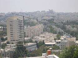
Ramat Eshkol
Ramat Eshkol (![]()
Historical background
In 1966, the border with Jordan ran parallel to Shmuel HaNavi Street. Beyond was a no man's land and the bunkers and fortifications of Ammunition Hill, the site of fierce battles between Jordanian and Israeli forces in the 1967 war.
According to ARIJ, Israel confiscated 416 dunams of land from the Palestinian neighbourhood of Shuafat in order to construct Ramat Eshkol.[3]
Ramat Eshkol (lit. "Eshkol Heights") was planned as a neighborhood with tree-lined streets, small parks, a neighborhood health clinic and a small commercial center with a supermarket. Most of the new apartment buildings were limited to four floors. The architecture included prefab elements, but outside walls were faced with a veneer of Jerusalem stone.[4]
Construction on Sderot Eshkol (Eshkol Boulevard), named for Israeli prime minister Levi Eshkol, began in 1968[5]
Israel Levitt of the Israel Defense Forces Engineering Corps cleared the mines on what is now Etzion Gaver street. Levitt, also a trained architect, designed the first buildings there. In January 1970, the first occupants moved in. There were no roads, and the nearest bus was on Shmuel Hanavi. The first minyan was held in an air raid shelter on Etzion Gaver street, before the completion of a synagogue.
Government policy at the time was to create a contiguous link from Shmuel Hanavi to French Hill and the campus of Hebrew University of Jerusalem on Mount Scopus.[6] A new bus line, number 9, was inaugurated to link the Mount Scopus campus with the campus in Givat Ram, built when the road to Mount Scopus was blocked by the Jordanians. The route of the bus followed the route of the convoy attacked on April 13, 1948, killing doctors and nurses of Hadassah Hospital.
Subdistricts
Building also began at this time in Givat HaMivtar. Plots were raffled off for the construction of single-family homes. A time limit was imposed on construction and access was difficult. The only access was via a muddy track. The construction of private homes on Ramat Hagolan Street in Ramat Eshkol also employed the lottery method.
Parks and memorials
After the Six-Day War, Ammunition Hill was restored and turned into a park and memorial site. Ramat Eshkol also has a park dedicated to Raoul Wallenberg, the Swedish diplomat who saved many Jews during World War II. The neighborhood's largest park is Gan HaHamishah Asar (Park of the Fifteen) commemorating fifteen soldiers killed in 1969 in one day of fighting during the War of Attrition.
Archaeology
The Eshkolot Tomb in Ramat Eshkol was discovered in the early 1970s during the excavation of building foundations. Eshkolot is the plural of Eshkol, meaning "cluster of grapes"; the tomb is named for the stone carving of a cluster of grapes over the entrance,[7] while the neighborhood is named for Levi Eshkol.
Today
Today, Ramat Eshkol is home to hundreds of religious Jewish families. It is an especially popular neighborhood for young American couples who have chosen to start their married life in Israel. A bustling hub for the surrounding areas, including Machal, Arzei HaBira, Sanhedria, Sanhedria Murchevet, Maalot Dafna and Givat HaMivtar, Ramat Eshkol boasts a large shopping center on Paran street, filled with eateries, groceries, a post office, nursing home and many other amenities. On a typical day, families, young mothers and their children can be seen running errands, going shopping and headed off to school and work.
The majority of Ramat Eshkol is made up of four-story apartment buildings, usually with small patches of grass in the front and back. On nearly every block, the neighborhood boasts another park, where children can be found playing with each other. The relative safety of the neighborhood allows children to roam about free during daylight hours—hanging out with their friends and learning independence.
References
- ↑ "Settlements in East Jerusalem". Foundation for Middle East Peace.
- ↑ "The Geneva Convention". BBC News. 10 December 2009. Retrieved 27 November 2010.
- ↑ Shu’fat Town Profile, ARIJ, 2013 p. 14
- ↑ "Jerusalem architecture since 1948". Jewish Virtual Library.
- ↑ "Ramat Eshkol - Eli Joseph's Jerusalem Real Estate Homepage and Buyer's Guide". A Jerusalem Home. Archived from the original on 25 December 2007.
- ↑ "Understanding Jerusalem". Middle East Quarterly.
- ↑ "1712-5-Eshkoloth-cave.jpg :: Zev Radovan's Gallery". Biblel and Pictures.
Neighborhoods of Jerusalem | ||
|---|---|---|
Jerusalem neighborhoods east of the 1949 armistice line are depicted in green, those west of the line in blue (see Green Line). | ||
| Old City |  | |
| Central Neighborhoods |
| |
| Northern Neighborhoods | ||
| Eastern Neighborhoods | ||
| Southern Neighborhoods | ||
| Western Neighborhoods | ||
| Historical Neighborhoods | ||
| ||
Coordinates: 31°48′9.36″N 35°13′24.44″E / 31.8026000°N 35.2234556°E