French Hill
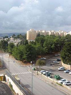
French Hill (Hebrew: הגבעה הצרפתית, HaGiv'a HaTzarfatit, Arabic: التلة الفرنسية, at-tel al-faransiya), also Giv'at Shapira (Hebrew: גִּבְעַת שַׁפִּירָא) is a neighborhood and Israeli settlement[1] in northern East Jerusalem. It is located on territory that has been occupied since the Six-Day War in 1967 and later unilaterally annexed by Israel under the Jerusalem Law in 1980 in a move not recognized internationally. The international community considers Israeli settlements in East Jerusalem, such as French Hill, illegal under international law, which the Israeli government disputes.[2]
Etymology
The source of the name French Hill is unclear. According to local legend, it was named after a British general, John French, 1st Earl of Ypres who is said to have had his headquarters on this hill. According to this legend there was a mistake with the translation to Hebrew that named the place after the country France (in Hebrew: Tzarfat). However, French never served in this region.[3][4] Had the neighborhood had been named for General French, the correct name in Hebrew would have been Giv'at French.[5] According to Israeli geographer Zev Vilnay, the land belonged to the Catholic Monastery of St Anne, whose monks hailed mainly from France.[6]
History
Under Jordanian rule, the area (Arabic: Karm el-Wiz)[7] was a military outpost.[8] According to Palestinian historian Walid Khalidi, a small number of Palestinians from Lifta moved to the area prior to 1967.[9]
In 1969, construction began on a new residential neighborhood to create a land link between West Jerusalem and the Hebrew University on Mount Scopus, which had been an Israeli enclave in Jordanian territory before the war.[10] The official name of the new neighborhood was Giv'at Shapira. Another section of French Hill, Tzameret HaBira, was populated mainly by American immigrants.[11]
Demographics
French Hill has a population of 6,631. Giv'at Shapira has a population density of 10.9 persons per dunam (10,900 people/km²), while Tzameret HaBira is less crowded, with 4.7 persons per dunam (4,700 people/km²). The population is mostly Jewish, including a large number of immigrants from South America and the former Soviet Union.[12]
In recent years, an increasing number of Arabs have been buying apartments in the neighborhood.[13] The neighborhood has also seen a large influx of Orthodox Jews in recent years. The ethnic mix is much more diverse than in most other Jewish areas in the city, partly due to the proximity of the Hebrew University and Hadassah Hospital on Mount Scopus.[13]
Schools and religious institutions
French Hill has 9 synagogues. One of them, Kehillat Ramot Zion (Hebrew: קהילת רמות ציון),[14] is a Conservative congregation. The first elementary school in Israel run by the Conservative movement, the Frankel School, was established in Givat Shapira.[15]
Arab-Israeli conflict
The French Hill intersection which connects northern Jerusalem to Maale Adumim and the Dead Sea has been the site of eleven Palestinian terror attacks.
According to an article by the US News and World Report, "the busy thoroughfare, which divides the Jewish neighborhood of French Hill from the Arab neighborhood of Shuafat, is the most accessible corner in the city for a West Bank terrorist looking for a crowd of Israelis."[16]
In 2004, members of the al-Aqsa Martyrs' Brigade shot and killed George Khoury, an Israeli Arab economics student, while he was jogging in French Hill.
Archaeology
A salvage dig in French Hill in 1970-1971 unearthed late Hellenistic and Herodian tombs. One of the 13 ossuaries discovered was inscribed with the name "Yehosef (Joseph) ben Haggai."[7]
Notable residents
References
- ↑ "Archived copy". Archived from the original on 2013-10-11. Retrieved 2014-02-18.
- ↑ "The Geneva Convention". BBC News. 10 December 2009. Retrieved 27 November 2010.
- ↑ "Trenches on the Web - Bio: General John French". Worldwar1.com. Retrieved 17 August 2017.
- ↑ "First World War.com - Who's Who - Sir John French". Firstworldwar.com. Retrieved 17 August 2017.
- ↑ "h2g2 - French Hill, Jerusalem - Edited Entry". Bbc.co.uk. Retrieved 17 August 2017.
- ↑ The Guide to Israel Zev Vilnay, Hamakor Press, Jerusalem, 1972, p. 130
- 1 2 French Hill, JSTOR 1356442
- ↑ "גבעת התחמושת". Givathatachmosht.org.il. Archived from the original on 9 April 2006. Retrieved 17 August 2017.
- ↑ Walid Khalidi All That Remains: The Palestinian Villages Occupied and Depopulated by Israel in 1948. Washington DC: Institute for Palestine Studies, 1992
- ↑ Understanding Jerusalem - Middle East Quarterly
- ↑ Statistical Yearbook of Jerusalem, 2002-2003. Jerusalem, Israel: Jerusalem Institute for Israel Studies; ISSN 0333-9831
- ↑ Statistical Yearbook of Jerusalem, 2002-2003 Jerusalem, Israel: Jerusalem Institute for Israel Studies; ISSN 0333-9831
- 1 2 Love thy neighbor, Jpost.com; accessed 15 August 2017.
- ↑ "ユニット型有料老人ホームについて". Ramot-zion.org. Retrieved 17 August 2017.
- ↑ "Jerusalem Neighborhood French Hill". Eifermanrealty.com. Retrieved 17 August 2017.
- ↑ "Archived copy". Archived from the original on 2012-03-24. Retrieved 2017-08-28.
Neighborhoods of Jerusalem | ||
|---|---|---|
Jerusalem neighborhoods east of the 1949 armistice line are depicted in green, those west of the line in blue (see Green Line). | ||
| Old City |  | |
| Central Neighborhoods |
| |
| Northern Neighborhoods | ||
| Eastern Neighborhoods | ||
| Southern Neighborhoods | ||
| Western Neighborhoods | ||
| Historical Neighborhoods | ||
| ||
| Wikimedia Commons has media related to French Hill. |
Coordinates: 31°48′20.52″N 35°14′20.37″E / 31.8057000°N 35.2389917°E