Beit HaKerem, Jerusalem
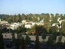
Beit HaKerem (Hebrew: בית הכרם; lit. "house of the vineyard") is a largely secular upscale neighborhood in southwest Jerusalem, Israel.[1] It is located between Kiryat Moshe to the northwest and Bayit VeGan to the south. Beit HaKerem has a population of 15,000.[2]
History
Remnants from the First Temple, Second Temple, Byzantine and Mamluk periods were discovered in a dig on HaSatat Street in 2006.[3] It is named for the biblical city of Beit Hakerem near Jerusalem[4] mentioned in Jeremiah 6:1 and Nehemiah 3:14.
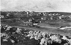
The neighborhood was founded in 1922 as one of six garden cities developed in Jerusalem during the days of the British Mandate for Palestine.[5] Beit HaKerem was planned by Ricard Kaufmann, an architect notable for his Bauhaus style, and was at the time separated from the rest of the city by large swaths of undeveloped land.[6] Beit Hakerem has continued to maintain its 'green' character.
According to a census conducted in 1931 by the British Mandate authorities, Beit HaKerem had a population of 550 inhabitants, in 148 inhabited houses.[7]
In the 1960s and 1970s, many university professors and students sought housing in Beit Hakerem due to its proximity to the Givat Ram campus of the Hebrew University, built when the Mount Scopus campus was cut off from Jerusalem in 1948.[8]
Education
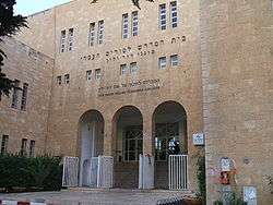
The neighborhood has 25 kindergartens, four elementary schools and three high schools considered among the most prestigious in Jerusalem.[9] The David Yellin College of Education, established in 1913, is located in Beit HaKerem,[10] as is the David Shapell College of Jewish Studies.[11] A footbridge from Beit HaKerem over the Begin Highway connects to the Givat Ram campus of the Hebrew University of Jerusalem.
Parks and monuments
Gan Ha'esrim park in Beit Hakerem (Park of the Twenty) commemorates 20 residents who died in Israel's War of Independence. Denmark Square (Kikar Denya) honors the Danish people for rescuing 90 percent of its Jewish population during the Holocaust. The monument in the square is shaped like a boat, recalling the boats on which Jews were smuggled to Sweden.[12] Two connecting parks for kids, Gan HaShachar and Gan HaGai, are also located in the neighborhood.
Transportation
The Jerusalem Light Rail, which began service in late 2011, passes through Beit HaKerem and has three stops there—Ha-'Haluts, Denia Square and Yefe Nof—providing convenient, rapid transportation to the Jerusalem Central Bus Station, the Binyanei Hauma international convention center, the soon to be completed (2018) terminus of the high-speed rail to Tel Aviv (28 minutes), Cinema City, the Machaneh Yehudah market, as well as to downtown Jerusalem, Zion Square, the Ben Yehudah pedestrian mall, Jerusalem City Hall, the Mamilla shopping mall and the Old City near Jaffa Gate and Damascus Gate.
Public services
Denmark Square in the center of Beit Hakerem has a number of shops, including an ice cream store, a large dairy restaurant, a pizza and falafel store, two banks, hair salons, clothing stores, a candy store, a flower store, a stationery store, a post office, Clalit health clinic, a book store, and a supermarket.[13]
Also in Beit Hakerem is the national headquarters of Yad Sarah, the largest voluntary organization in Israel, lending medical equipment and providing other services for free or at nominal costs.
In the area bordering both Beit Hakerem and Ramat Beit Hakerem there is another larger shopping area with another supermarket, a soap store, a pharmacy, a wine store, a flower store, a housewares store, a children’s clothing store, a health food store, a jewelry store, an ice cream store, a bank, a number of restaurants and cafés, and a bookstore. There is a private residence for senior citizens above the shops. The Shaare Zedek Medical Center, one of Jerusalem's main hospitals, is located across the street.
Notable residents

- Nir Barkat, Mayor of Jerusalem
- Yehoram Gaon, singer, actor, director, producer, and TV and radio host
- Anat Hoffman, President of Women Of The Wall
- Elon Lindenstrauss, Mathematician.
- Reuven Rivlin, President of The State Of Israel
- Alice Shalvi,[14] Educator
- Karnit Flug, Governor of The Bank Of Israel
- Chava Turniansky, Prass Israel 2013
References
- ↑ Riding Out the Storm
- ↑ Jerusalem neighborhoods
- ↑ Israel Antiquities Authority - Articles
- ↑ Carta's Official Guide to Israel and Complete Gazetteer to all Sites in the Holy Land. (3rd edition 1993) Jerusalem, Carta, p.233, ISBN 965-220-186-3 (English)
- ↑ British Mandate:Garden suburbs
- ↑ Jerusalem and its Environs:Quarters, Neighborhoods, Villages, Ruth Kark
- ↑ Mills, 1932, p. 38
- ↑ The Way They Were, In Jerusalem, Jerusalem Post
- ↑ The Way They Were, In Jerusalem, Jerusalem Post
- ↑ David Yellin College of Education
- ↑ "Home - Shapell's /Darche Noam". Shapell's /Darche Noam. Retrieved 2016-11-21.
- ↑ Parshat Va-eira 5764 - Aloh Na'aleh - OU.ORG
- ↑ "Beit Hakerem". Website of Jerusalem Municipality. Retrieved 2016-11-21.
- ↑ An interview with Alice Shalvi
External links
![]()
Neighborhoods of Jerusalem | ||
|---|---|---|
Jerusalem neighborhoods east of the 1949 armistice line are depicted in green, those west of the line in blue (see Green Line). | ||
| Old City |  | |
| Central Neighborhoods |
| |
| Northern Neighborhoods | ||
| Eastern Neighborhoods | ||
| Southern Neighborhoods | ||
| Western Neighborhoods | ||
| Historical Neighborhoods | ||
| ||
Coordinates: 31°46′44″N 35°11′24″E / 31.77889°N 35.19000°E