Cairo, New York
| Cairo, New York | |
|---|---|
| Town | |
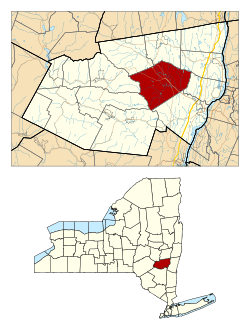 Location in Greene County and the state of New York | |
| Coordinates: 42°18′08″N 73°59′44″W / 42.30222°N 73.99556°WCoordinates: 42°18′08″N 73°59′44″W / 42.30222°N 73.99556°W | |
| Country | United States |
| State | New York |
| County | Greene |
| Established | 1803 |
| Government | |
| • Type | Town Council |
| • Town Supervisor | Daniel Benoit (R) |
| • Town Council |
Members
|
| Area[1] | |
| • Total | 60.08 sq mi (155.61 km2) |
| • Land | 59.83 sq mi (154.95 km2) |
| • Water | 0.25 sq mi (0.66 km2) |
| Population (2010) | |
| • Total | 6,670 |
| • Estimate (2016)[2] | 6,454 |
| • Density | 107.88/sq mi (41.65/km2) |
| Time zone | UTC-5 (EST) |
| • Summer (DST) | UTC-4 (EDT) |
| FIPS code | 36-039-11649 |
Cairo /ˈkɛəroʊ/ is a town in Greene County, New York, United States. The population was 6,610 at the 2010 census.[3] The town is in the south part of the county, partly in the Catskill Park. The town contains a hamlet also named Cairo.
History
The first settler arrived around 1772, but many new families moved in after the American Revolution. In 1803, the town of Cairo was formed from the towns of Catskill, Coxsackie, and Durham. Formerly known as "Canton", the town's name was changed in 1808 to "Cairo".[4] The accepted pronunciation is "care-oh", and newcomers are quickly advised of this.
From 1800 the Susquehannah Turnpike, a private toll road, ran through the town. The only railroad, the Canajoharie and Catskill Railroad, ran through the town, but only operated from about 1839 to 1842.
Geography
According to the United States Census Bureau, the town has a total area of 60.1 square miles (155.8 km²), of which 60.0 square miles (155.3 km²) is land and 0.2 square miles (0.4 km², or 0.27%) is water.
Catskill Creek flows through the town.
Demographics
| Historical population | |||
|---|---|---|---|
| Census | Pop. | %± | |
| 1820 | 2,353 | — | |
| 1830 | 2,912 | 23.8% | |
| 1840 | 2,862 | −1.7% | |
| 1850 | 2,831 | −1.1% | |
| 1860 | 2,479 | −12.4% | |
| 1870 | 2,283 | −7.9% | |
| 1880 | 2,287 | 0.2% | |
| 1890 | 2,191 | −4.2% | |
| 1900 | 2,176 | −0.7% | |
| 1910 | 1,841 | −15.4% | |
| 1920 | 1,487 | −19.2% | |
| 1930 | 1,772 | 19.2% | |
| 1940 | 1,905 | 7.5% | |
| 1950 | 1,944 | 2.0% | |
| 1960 | 2,825 | 45.3% | |
| 1970 | 3,546 | 25.5% | |
| 1980 | 4,729 | 33.4% | |
| 1990 | 5,418 | 14.6% | |
| 2000 | 6,358 | 17.3% | |
| 2010 | 6,670 | 4.9% | |
| Est. 2016 | 6,454 | [2] | −3.2% |
| U.S. Decennial Census[5] | |||
As of the census[6] of 2000, there were 6,355 people, 2,579 households, and 1,709 families residing in the town. The population density was 106.0 people per square mile (40.9/km²). There were 3,322 housing units at an average density of 55.4 per square mile (21.4/km²). The racial makeup of the town was 96.87% White, 0.55% Black or African American, 0.33% Native American, 0.22% Asian, 0.60% from other races, and 1.43% from two or more races. Hispanic or Latino of any race were 3.67% of the population.
There were 2,579 households out of which 29.9% had children under the age of 18 living with them, 51.6% were married couples living together, 10.3% had a female householder with no husband present, and 33.7% were non-families. 28.4% of all households were made up of individuals and 14.0% had someone living alone who was 65 years of age or older. The average household size was 2.44 and the average family size was 3.00.
In the town, the population was spread out with 25.2% under the age of 18, 6.2% from 18 to 24, 26.3% from 25 to 44, 25.1% from 45 to 64, and 17.3% who were 65 years of age or older. The median age was 40 years. For every 100 females, there were 93.8 males. For every 100 females age 18 and over, there were 90.1 males.
The median income for a household in the town was $35,995, and the median income for a family was $41,820. Males had a median income of $36,590 versus $25,538 for females. The per capita income for the town was $19,407. About 6.1% of families and 10.4% of the population were below the poverty line, including 10.3% of those under age 18 and 10.9% of those age 65 or over.
Communities and locations in Cairo
- Acra – A hamlet west of Cairo hamlet on Route 23.
- Cairo – The hamlet and census-designated place of Cairo.
- Gayhead – A hamlet at the north town line.
- Purling – A hamlet south of Cairo hamlet.
- Round Top – A hamlet southwest of Purling.
- South Cairo – A hamlet southeast of Cairo hamlet on Route 23.
- South Durham – A hamlet at the west town line.
- Woodstock[7] – A populated place north of Cairo on Route 32, along Catskill Creek.
Public safety
Cairo has two fire companies: Cairo Fire District and Round Top Vol. Fire Co. Inc. Cairo Ambulance responds to medical emergencies in the town.
Notable people
- Joseph Alden (1807–1885), born in Cairo, noted academic and author of over seventy books[8]
- Jennifer Connelly (born 1970), born in Cairo, Academy Award-winning actress[9]
- Jack Diamond, bootlegger and gangster, twice shot in town, once at a private dinner, and another time at the Aratoga Inn He also owned a home in Acra.
- Rob LeDonne (born 1987 in Brooklyn, NY), attended Cairo-Durham Central Schools, writer for numerous TV shows and periodicals[10][11]
- Thurlow Weed (1797–1882), born in Cairo, newspaper editor and political boss who promoted, by turns (and sometimes simultaneously), the National Republican, Anti-Masonic, Whig and Republican parties
References
- ↑ "2016 U.S. Gazetteer Files". United States Census Bureau. Retrieved Jul 5, 2017.
- 1 2 "Population and Housing Unit Estimates". Retrieved June 9, 2017.
- ↑ "Geographic Identifiers: 2010 Demographic Profile Data (G001): Cairo town, Greene County, New York". American Factfinder. U.S. Census Bureau. Retrieved December 29, 2016.
- ↑ Vasiliev, Ren. From Abbotts to Zurich: New York State Placenames. Syracuse University Press. p. 33.
- ↑ "Census of Population and Housing". Census.gov. Archived from the original on April 22, 2013. Retrieved June 4, 2015.
- ↑ "American FactFinder". United States Census Bureau. Retrieved 2008-01-31.
- ↑ U.S. Geological Survey Geographic Names Information System: Woodstock
- ↑ Who Was Who in America, Historical Volume, 1607-1896. Marquis Who's Who. 1967.
- ↑ Sischy, Ingrid (April 1, 2002). "How Holding out for Something that Mattered Paid Off". Interview Magazine. Brant Publications.
- ↑ "IMDB Page".
- ↑ http://www.robledonne.com
Municipalities and communities of Greene County, New York, United States | ||
|---|---|---|
| Towns |  | |
| Villages | ||
| CDPs | ||
| Other hamlets | ||