Borough of Burnley
Coordinates: 53°47′13″N 2°14′42″W / 53.787°N 2.245°W
| Borough of Burnley | ||
|---|---|---|
| Borough | ||
 Burnley Town Hall | ||
| ||
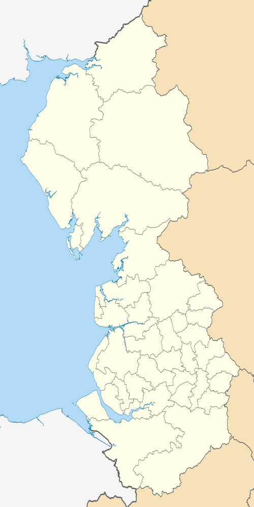
 Shown within ceremonial Lancashire | ||
| Sovereign state | United Kingdom | |
| Constituent country | England | |
| Region | North West England | |
| Ceremonial county | Lancashire | |
| Admin. HQ | Burnley | |
| Government | ||
| • Type | Burnley Borough Council | |
| • Leadership: | Leader & Cabinet | |
| • Executive: | Labour Party | |
| • MPs: | Julie Cooper | |
| Area | ||
| • Total | 42.7 sq mi (110.7 km2) | |
| Area rank | 209th | |
| Population (mid-2017 est.) | ||
| • Total | 87,700 | |
| • Rank | Ranked 277th | |
| • Density | 2,100/sq mi (790/km2) | |
| Time zone | UTC+0 (Greenwich Mean Time) | |
| • Summer (DST) | UTC+1 (British Summer Time) | |
| Postcode | BB10-12 | |
| Area code(s) | 01282 | |
| ONS code |
30UD (ONS) E07000117 (GSS) | |
| Ethnicity |
90.1% White 8.2% S.Asian 0.9% Mixed Race[1] | |
| Website | burnley.gov.uk | |
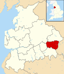
The Borough of Burnley (/ˈbɜːrnli/) is a local government district of Lancashire, England, with the status of a non-metropolitan district and borough. It has an area of 42.7 square miles (110.7 km2) and a population of 87,700 (mid-2017 est.), and is named after its largest town, Burnley. The borough is bounded by Hyndburn, Ribble Valley, Pendle, Rossendale – all in Lancashire – and the borough of Calderdale in West Yorkshire. It is governed by Burnley Borough Council, which has been controlled by the Labour Party since 2015
History
The district was formed on 1 April 1974, when the former county borough of Burnley merged with the urban district of Padiham and part of Burnley Rural District.
At this time Simonstone and the civil parish of North Town (historically associated with Padiham) were included in the borough, with the two merging in 1983. However after a public campaign to move Simonstone into the Borough of Ribble Valley and Boundary Commission review completed in 1985, the part of North Town south of the A6068 Padiham Bypass was added to Ightenhill. Another part was transferred to Pendle district's Higham with West Close Booth and small adjustments occurred to the boundaries with Padiham and Hyndburn's Altham along the River Calder.[2]
In 2007 its proposal to merge with neighbouring Pendle Borough Council to form a larger unitary authority was rejected by the government.[3]
Governance
| Burnley Borough Council | ||||
|---|---|---|---|---|
 |
 | |||
| Party | Seats | Changes (compared with 2016) | ||
| Labour | 25 | |||
| Liberal Democrat | 5 | |||
| Conservative | 5 | |||
| BAPIP | 4 | |||
| Independent | 3 | |||
| UKIP | 2 | |||
| Green | 1 | 2018 local election results in Burnley | ||
Burnley Borough Council has had a predominantly Labour controlled history, the party returned to power in 2012, after a period of leadership by the Liberal Democrats. The borough comprises 15 wards electing a total of 45 councillors.
Wards: Bank Hall, Briercliffe, Brunshaw, Coal Clough with Deerplay, Daneshouse with Stoneyholme, Gannow, Lanehead, Queensgate, Rosegrove with Lowerhouse, Rosehill with Burnley Wood, Trinity, and Whittlefield with Ightenhill, Cliviger with Worsthorne, Gawthorpe, and Hapton with Park.
The borough contains the civil parishes of Ightenhill, Habergham Eaves, Dunnockshaw, Hapton, Cliviger, Briercliffe, and Worsthorne-with-Hurstwood.
Padiham Town Council was established in 2002.
Since 2002, a number of BNP councillors have been elected in the borough, with the last councillor losing her seat in the Hapton with Park ward in 2012.
Geography
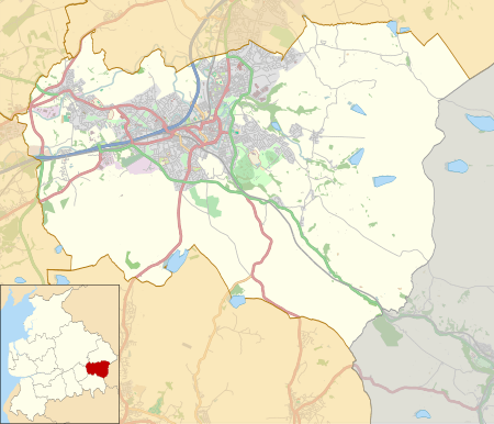
Places in the borough of Burnley include:
 Brownside Cockden Lane Bottom Southward Bottom Rogerham
|
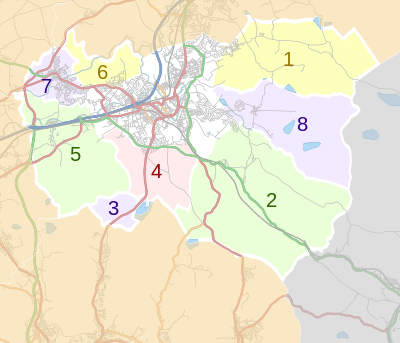 Civil parishes: 1.Briercliffe-with-Extwistle, 2.Cliviger, 3.Dunnockshaw, 4.Habergham Eaves 5.Hapton, 6.Ightenhill, 7.Padiham, 8.Worsthorne-with-Hurstwood
|
Media gallery
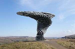 The Singing Ringing Tree, overlooking Burnley.
 Clowbridge Reservoir, Dunnockshaw.
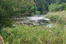 River Calder near Gawthorpe Hall.
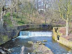 The old weir on the River Brun near Bank Hall in Burnley.
.jpg) On the Burnley Way in Ightenhill. The footpath circles the borough.
On the Burnley Way in Ightenhill. The footpath circles the borough.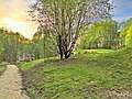 The former site of Towneley Colliery on the edge of Habergham Eaves.
Demography
| The Borough of Burnley compared | |||
|---|---|---|---|
| UK Census 2011 | Burnley[4] | NW England[5] | England[6] |
| Total population | 87,059 | 7,052,177 | 53,012,456 |
| Foreign born | 7.7% | 8.2% | 13.8% |
| White | 87.4% | 90.2% | 85.4% |
| Asian | 10.7% | 5.5% | 7.1% |
| Black | 0.2% | 1.4% | 3.5% |
| Christian | 63.6% | 67.3% | 59.4% |
| Muslim | 9.9% | 5.1% | 5.0% |
| Hindu | 0.2% | 0.5% | 1.5% |
| No religion | 19.7% | 19.8% | 24.7% |
| Under 18 years old | 22.2% | 21.2% | 21.4% |
| Over 65 years old | 16.2% | 16.6% | 16.3% |
| Unemployed | 5.3% | 4.7% | 4.4% |
| Perm. sick / disabled | 7.0% | 5.6% | 4.0% |
The borough's population has fallen from a high of 130,339 in 1911 to an estimated 87,700 in 2005.[7] Between 1991 and 2001, it fell by 2.6%. Its employment rate of 59.0% places it 261st out of 376 local authorities in England & Wales; just 12.6% of its workforce are graduates, placing it 325th out of 376 local authorities.[8]
A 2010 report commissioned by the BBC and compiled by Experian ranked the borough as having the second lowest property prices in England, this combined with GCSE results and crime rates, led to the borough being ranked as the worst place in England.[9]
Public services
Education
Education Services in the borough are provided and controlled by Lancashire County Council.
Health
Health services in the borough are provided by East Lancashire Primary Care Trust and East Lancashire Hospitals NHS Trust, with additional services provided by the North West Ambulance Service and North West Air Ambulance.
The Hospital Trust operates Burnley General Hospital, while the PCT operates the network of GP surgeries, and recently opened 2 Primary Health Care Centres in the borough (St. Peters Centre in 2006 and Briercliffe in 2007).[10]
Policing
Policing Services in the borough are provided by the Pennine division of Lancashire Constabulary based at Burnley Police station, and controlled by Lancashire County Council. Plans are in place to merge the pennine division into the neighbouring eastern division, based in Blackburn.[11] Policing Services of the borough's Railways are provided by North West division of the British Transport Police – the nearest Transport Police office being in Preston.[12]
Fire and rescue
Fire and rescue services in the borough are provided by Lancashire Fire and Rescue Service and controlled by Lancashire County Council.
Waste and recycling
Refuse and Recycling Collections, and Street Cleansing services are the responsibly of the borough council, and these services are currently contracted to Urbaser Ltd.
The borough Council has signed up to Lancashire's Municipal Waste Management Strategy, which specifies that the borough must recycle or compost 56% of all waste by 2015 and 61% by 2020.
There are currently 2 household waste recycling centres run by Lancashire County Council in the borough. One located on Grosvenor Street in Burnley and the second on Park Road in Padiham. Lancashire County Councils long term plans to replace the Burnley site with facility at Heasandford Industrial Estate on the north eastern edge of the town, where approved in 2010 despite local objections regarding the site's suitability. 3 months later they then announced the closure of the Padiham site as part of cost-cutting measures, increasing the unsuitability of the new Burnley site's location.[13]
Neighbouring districts
Neighbouring districts | |
|---|---|
See also
| Wikimedia Commons has media related to Burnley. |
References
- ↑ www.neighbourhood.statistics.gov.uk.. Retrieved 27 March 2008.
- ↑ "Local Government Boundary Commission For England Report No. 5O5" (PDF). Local Government Boundary Commission For England. October 1985. Archived from the original (PDF) on 18 November 2015. Retrieved 13 March 2017.
- ↑ "Government says no to home rule for Burnley and Pendle" Archived 28 September 2007 at the Wayback Machine., Burnley Borough Council website, 27 March 2007. Retrieved 30 August 2007.
- ↑ UK Census (2011). "Local Area Report – Burnley Local Authority (1946157091)". Nomis. Office for National Statistics. Retrieved 9 February 2018.
- ↑ UK Census (2011). "Local Area Report – North West Region (2013265922)". Nomis. Office for National Statistics. Retrieved 9 February 2018.
- ↑ UK Census (2011). "Local Area Report – England Country (2092957699)". Nomis. Office for National Statistics. Retrieved 9 February 2018.
- ↑ A Vision of Britain Through Time Archived 30 September 2007 at the Wayback Machine.. Retrieved 6 May 2008.
- ↑ Office for National Statistics|2001 Census. Retrieved 6 May 2008.
- ↑ BBC News (Excel Spreatsheet) Accessed 2010
- ↑ East Lancs PCT Archived 30 July 2010 at the Wayback Machine. Accessed 2010
- ↑ Blackburn chosen as new police base for Eastern division Your Local Guardian. Retrieved 2013
- ↑ Transport Police Stations in the North West Accessed 2013
- ↑ Lancashire Telegraph. Retrieved 2010
Geography of the Borough of Burnley | |||||||
|---|---|---|---|---|---|---|---|
| Towns | 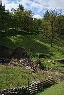 | ||||||
| Villages & suburbs | |||||||
| Parishes | |||||||
| Topography |
| ||||||
Buildings and structures in the Borough of Burnley | |||||
|---|---|---|---|---|---|
| Grade I | 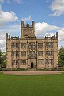 | ||||
| Grade II* | |||||
| Grade II |
| ||||
| Listed in | |||||
| Unlisted |
| ||||
Culture and infrastructure of the Borough of Burnley | ||||||||||
|---|---|---|---|---|---|---|---|---|---|---|
| Transport |
|  | ||||||||
| Education | ||||||||||
| Sport | ||||||||||
| History | ||||||||||
| Media | ||||||||||
| Politics | ||||||||||