Limy Water
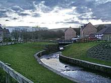
Limy Water at Loveclough
The Limy Water is a minor river in Lancashire, England. It is 4.95 miles (7.96 km) long and has a catchment area of 7.71 square miles (1,996.33 ha).[1]
The stream rises on the hillside close to Crown Point in Habergham Eaves near Burnley just east of the Clowbridge Reservoir which it feeds. After exiting the reservoir and crossing the A862 Burnley Road it heads southwest to the Hillside Fishery at Loveclough, where it turns to the south, continuing on to Goodshaw. Continuing past Crawshawbooth and through the centre of Rawtenstall where it joins the River Irwell.[2]
References
| Wikimedia Commons has media related to Limy Water. |
- ↑ "Limy Water". Catchment Data Explorer. Environment Agency. Retrieved 12 November 2017.
- ↑ "103" (Map). Blackburn & Burnley (C2 ed.). 1:50,000. Landranger. Ordnance Survey. 2006. ISBN 978-0-319-22829-6.
| Next confluence upstream | River Irwell | Next confluence downstream |
| Whitewell Brook (North) | Limy Water | River Ogden (West) |
Geography of the Borough of Burnley | |||||||
|---|---|---|---|---|---|---|---|
| Towns |  | ||||||
| Villages & suburbs | |||||||
| Parishes | |||||||
| Topography |
| ||||||
Coordinates: 53°52′12″N 2°24′57″W / 53.8701°N 2.4157°W
This article is issued from
Wikipedia.
The text is licensed under Creative Commons - Attribution - Sharealike.
Additional terms may apply for the media files.