Hiers-Brouage
| Hiers-Brouage | ||
|---|---|---|
| Commune | ||
 Citadel | ||
| ||
 Hiers-Brouage Location within Nouvelle-Aquitaine region  Hiers-Brouage | ||
| Coordinates: 45°51′02″N 1°04′28″W / 45.8505°N 1.0744°WCoordinates: 45°51′02″N 1°04′28″W / 45.8505°N 1.0744°W | ||
| Country | France | |
| Region | Nouvelle-Aquitaine | |
| Department | Charente-Maritime | |
| Arrondissement | Rochefort | |
| Canton | Marennes | |
| Government | ||
| • Mayor (2008–2014) | Patrick Pellet | |
| Area1 | 31.35 km2 (12.10 sq mi) | |
| Population (2008)2 | 639 | |
| • Density | 20/km2 (53/sq mi) | |
| Time zone | UTC+1 (CET) | |
| • Summer (DST) | UTC+2 (CEST) | |
| INSEE/Postal code | 17189 /17320 | |
| Elevation | 0–26 m (0–85 ft) | |
|
1 French Land Register data, which excludes lakes, ponds, glaciers > 1 km2 (0.386 sq mi or 247 acres) and river estuaries. 2 Population without double counting: residents of multiple communes (e.g., students and military personnel) only counted once. | ||
.svg.png)
Hiers-Brouage is a commune in the Charente-Maritime department in southwestern France.
History
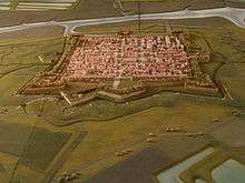
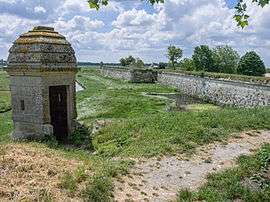
Brouage was founded in 1555 by Jacques de Pons on the Bay of Biscay facing the Atlantic Ocean. Its economy was based on salt and access to the sea. The town was fortified between 1630 and 1640 by Cardinal Richelieu as a Catholic bastion in order to fight against the neighbouring Protestant town of La Rochelle. Gradually the harbour silted up in the last part of the 17th century, leaving the town stranded and useless as a port. It fell into ruin.
The town's most celebrated son is the French navigator Samuel de Champlain, who lived there when young, before being the co-founder of French settlement in Acadia (1604–1607) and Quebec (1608–1635).
In 1825 Brouage was joined to the village of Hiers, 2.5 km (1.6 mi) away, forming the commune of Hiers-Brouage.
Population
| Historical population | ||
|---|---|---|
| Year | Pop. | ±% |
| 1793 | 391 | — |
| 1800 | 413 | +5.6% |
| 1806 | 326 | −21.1% |
| 1821 | 372 | +14.1% |
| 1831 | 764 | +105.4% |
| 1836 | 804 | +5.2% |
| 1841 | 778 | −3.2% |
| 1846 | 901 | +15.8% |
| 1851 | 760 | −15.6% |
| 1856 | 840 | +10.5% |
| 1861 | 742 | −11.7% |
| 1866 | 708 | −4.6% |
| 1872 | 695 | −1.8% |
| 1876 | 708 | +1.9% |
| 1881 | 766 | +8.2% |
| 1886 | 733 | −4.3% |
| 1891 | 687 | −6.3% |
| 1896 | 715 | +4.1% |
| 1901 | 668 | −6.6% |
| 1906 | 663 | −0.7% |
| 1911 | 639 | −3.6% |
| 1921 | 534 | −16.4% |
| 1926 | 550 | +3.0% |
| 1931 | 546 | −0.7% |
| 1936 | 560 | +2.6% |
| 1946 | 514 | −8.2% |
| 1954 | 500 | −2.7% |
| 1962 | 541 | +8.2% |
| 1968 | 519 | −4.1% |
| 1975 | 440 | −15.2% |
| 1982 | 476 | +8.2% |
| 1990 | 498 | +4.6% |
| 1999 | 472 | −5.2% |
| 2008 | 639 | +35.4% |
Sights
- The village church dedicated to Saint Peter and Saint Paul built in 1608. Since 1982, several stained glass windows have been installed by Quebec and New Brunswick to commemorate historical figures of New France, including Samuel de Champlain who was living when young in the village.
- The Samuel de Champlain Museum.
- The walls of the ramparts of the citadel of Brouage.
- The Porte royale or King's gate which gave access to the quais.
- The Saint-Luc powderhouse (poudrière) with four flying-buttresses.
- The Halle aux vivres or Warehouse built to store goods and supplies for the citadel.
See also
References
External links
| Wikimedia Commons has media related to Hiers-Brouage. |