Brooklyn Heights Historic District
|
Brooklyn Heights Historic District | |
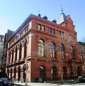 The Brooklyn Historical Society (2013) | |
   | |
| Location |
Bounded by Atlantic Ave., Court and Fulton Sts. and the BQE Brooklyn, New York City |
|---|---|
| Coordinates | 40°41′48″N 73°59′48″W / 40.69667°N 73.99667°WCoordinates: 40°41′48″N 73°59′48″W / 40.69667°N 73.99667°W |
| Area | 140 acres (57 ha) |
| Architect | multiple |
| Architectural style | Greek Revival, Late Victorian, Gothic |
| NRHP reference # | 66000524[1] |
| Significant dates | |
| Added to NRHP | October 15, 1966 |
| Designated NHLD | January 12, 1965[2] |
| Designated NYCL | September 26, 1978 |
The Brooklyn Heights Historic District is a historic district that comprises much of the Brooklyn Heights neighborhood of Brooklyn, New York City. It was named a National Historic Landmark in January, 1965,[2] designated a New York City Landmark in November, 1965,[3] and added to the National Register of Historic Places in October, 1966.[4]
The district is bounded by Cadman Plaza West (Old Fulton Street) on the north, the Brooklyn-Queens Expressway on the west, Atlantic Avenue on the south, and an irregular line that partly follows Clinton and Henry Streets on the east.[3] It is of national significance as an early commuter suburb, and as a remarkably well-preserved 19th-century urban streetscape.[4]
Grace Episcopal Church, designed by Richard Upjohn, which held its first service in 1848,[5] is in the district, as are Plymouth Church of the Pilgrims, Our Lady of Lebanon Maronite Catholic Cathedral, the First Presbyterian Church, the First Unitarian Congregational Society, the Long Island (Brooklyn) Historical Society, the Heights Casino and Casino Apartments, Packer Collegiate Institute, and St. Ann's and the Holy Trinity Church, among other historically notable buildings.[6]
The development of Brooklyn Heights as a fashionable residential area began with the introduction of ferry service to Manhattan in 1814. By the mid-19th century, the area was served by three ferry services as well as the Brooklyn and Jamaica Railroad, and it was one of New York's premier residential addresses. The latter distinction was eventually eclipsed by Fifth Avenue. Some of its streets are named for early real estate developers.[4]
Gallery
 Middagh Street
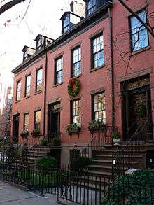 150–159 Willow Street, early 19th-century Federal houses
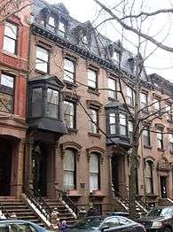 Rowhouses on Remsen Street
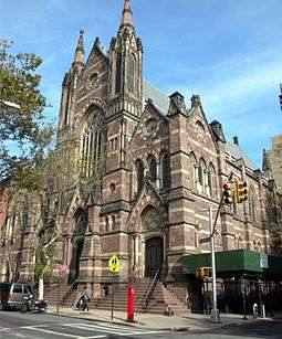
 Grace Episcopal Church

.jpg) The Brooklyn Heights Casono at 75 Montague Street
The Brooklyn Heights Casono at 75 Montague Street
See also
References
Notes
- ↑ National Park Service (2009-03-13). "National Register Information System". National Register of Historic Places. National Park Service.
- 1 2 "Brooklyn Heights Historic District". National Historic Landmark summary listing. National Park Service. 2007-09-14.
- 1 2 New York City Landmarks Commission. "Brooklyn Heights Historic District, Brooklyn, Designated November 23, 1965" (pdf). New York City Landmarks Commission.
- 1 2 3 Heintzelman, Patricia (May 1975). "National Register of Historic Places Inventory-Nomination: Brooklyn Heights" (pdf). National Park Service. and Accompanying photos, from 1975. (5.89 MB)
- ↑ "A Brooklyn Church Uncovers a Long-Hidden Celestial Scene". The New York Times. December 25, 2013. Retrieved 2013-12-26.
Grace Church was designed by the master architect Richard Upjohn, the confident hand behind Trinity Church on Wall Street. The first service was held at Grace in 1848.
- ↑ New York City Landmarks Preservation Commission; Dolkart, Andrew S.; Postal, Matthew A. (2009), Postal, Matthew A., ed., Guide to New York City Landmarks (4th ed.), New York: John Wiley & Sons, ISBN 978-0-470-28963-1 , pp.230-235
External links

| Topics |   | |
|---|---|---|
| Lists by county |
| |
| Lists by city | ||
| Other lists | ||
| ||