Briones Hills
| Briones Hills | |
|---|---|
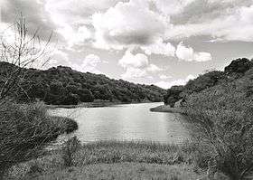 Briones Reservoir in the Briones Hills. | |
| Highest point | |
| Elevation | 430 m (1,410 ft) |
| Geography | |
 Location of Briones Hills in California[1] | |
| Country | United States |
| State | California |
| District | Contra Costa County |
| Range coordinates | 37°56′34.725″N 122°8′47.876″W / 37.94297917°N 122.14663222°WCoordinates: 37°56′34.725″N 122°8′47.876″W / 37.94297917°N 122.14663222°W |
| Topo map | USGS Briones Valley |
| Geology | |
| Type of rock |
Inner Coast Ranges, California Coast Ranges System |
The Briones Hills form a low mountain range in western Contra Costa County, in the East Bay region of the San Francisco Bay Area, California, United States.[1]
Geography
The hills are in the Southern Inner Coast Ranges group of the California Coast Ranges System.
Cities and towns adjacent to or in the foothills of the range include: Briones, Lafayette, Martinez, Orinda, Pleasant Hill, Alhambra Valley, and Walnut Creek.
Features
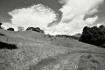
Briones Regional Park, in the East Bay Regional Park District System, provides hiking trails for access. It also protects some of the range's California oak woodland, chaparral, and riparian habitats.
Briones Reservoir, of the East Bay Municipal Utility District (EBMUD), is located in the western area. It is impounded by Briones Dam on Bear Creek.
The headwaters of Pinole Creek are in the Briones Hills, on the western slope of Costa Peak. The headwaters of Alhambra Creek are in the hills within Briones Regional Park.
See also
- Mountain ranges of the San Francisco Bay Area
- Natural history of the California Coast Ranges
References
- 1 2 "Briones Hills". Geographic Names Information System. United States Geological Survey. Retrieved 2009-05-04.
| Bodies of water |
|  |
|---|---|---|
| Counties | ||
| Major cities | ||
| Cities and towns 100k–250k | ||
| Cities and towns 50k–99k | ||
| Cities and towns 25k-50k | ||
| Cities and towns 10k–25k |
| |
| Sub-regions | ||