Brightview, Queensland
| Brightview Queensland | |||||||||||||||
|---|---|---|---|---|---|---|---|---|---|---|---|---|---|---|---|
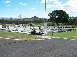 Looking across Brightview Apostolic cemetery to the fields beyond, 2005 | |||||||||||||||
 Brightview | |||||||||||||||
| Coordinates | 27°30′53″S 152°28′35″E / 27.5147°S 152.4763°ECoordinates: 27°30′53″S 152°28′35″E / 27.5147°S 152.4763°E | ||||||||||||||
| Population | 813 (2016 census)[1] | ||||||||||||||
| • Density | 32.01/km2 (82.90/sq mi) | ||||||||||||||
| Postcode(s) | 4311 | ||||||||||||||
| Area | 25.4 km2 (9.8 sq mi) | ||||||||||||||
| LGA(s) | Lockyer Valley Region | ||||||||||||||
| State electorate(s) | Lockyer | ||||||||||||||
| Federal Division(s) | |||||||||||||||
| |||||||||||||||
Brightview is a locality split between the Lockyer Valley Region and Somerset Region, Queensland, Australia.[2] In the 2016 census, Brightview had a population of 813 people.[1]
Geography
Brightview is a rural locality. The larger north-eastern part (15.9 square kilometres (6.1 sq mi)) is in Somerset Region and is mostly used for farming; that part is in the federal electorate of Blair. The smaller south-western part (8.5 square kilometres (3.3 sq mi)) in Lockyer Valley Region is more residential in character; that part is in the federal electorate of Wright.[3]
The northern boundary is Lockyer Creek.[3] Brightview Weir is located on the creek at 27°29′47″S 152°30′05″E / 27.4965°S 152.5013°E.[4]
History
Brightview was originally named Tarampa Flats and then Lobethal. It is thought the present name was the name of a pastoral property owned by Ernest Christian Frederick Beutel.[2]
Tarampa Flat Provisional School opened on 25 November 1902, being renamed Brightview Provisional School in 1906. It became Brightview State School on 1 January 1909. It closed on 11 May 1962.[5]
It is unclear when the Apostolic church opened, but an Apostolic congregation was already established in Tarampa Flats by 1911.[6]
| Year | Population | Notes |
|---|---|---|
| 1911 | 131 | [7] |
| 1933 | 180 | [7] |
| 1961 | 158 | [7] |
| 2001 | 675 | [7] |
| 2006 | 895 | [7] |
Amenities
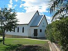
The Apostolic Church of Queensland has a church and adjoining cemetery at 22 Thorne Street just off Brightview Road.[8]
References
- 1 2 Australian Bureau of Statistics (27 June 2017). "Brightview (SSC)". 2016 Census QuickStats. Retrieved 7 October 2018.

- 1 2 "Brightview - locality in Lockyer Valley Region (entry 44945)". Queensland Place Names. Queensland Government. Retrieved 30 December 2017.
- 1 2 "Queensland Globe". State of Queensland. Retrieved 7 October 2018.
- ↑ "Brightview Weir - weir in Somerset Region (entry 4539)". Queensland Place Names. Queensland Government. Retrieved 7 October 2018.
- ↑ Queensland Family History Society (2010), Queensland schools past and present (Version 1.01 ed.), Queensland Family History Society, ISBN 978-1-921171-26-0
- ↑ "German Apostolic Church Jubilee". Queensland Times. LIII, (8186). Queensland, Australia. 1 August 1911. p. 6 (DAILY). Retrieved 7 October 2018 – via National Library of Australia.
- 1 2 3 4 5 "Population by cities, towns, localities & suburbs 1861 to 2008p". Queensland Government. Retrieved 7 October 2018.
- ↑ "The Apostolic Church of Queensland - Brightview". Australia's Christian Heritage. Retrieved 7 October 2018.
Further reading
- Lowood State School : 125th anniversary, 29th July 2006. 125th Anniversary Committee, Lowood State School. 2006. — contains information about Brightview State School
External links
![]()