Mount Sylvia, Queensland
| Mount Sylvia Queensland | |||||||||||||||
|---|---|---|---|---|---|---|---|---|---|---|---|---|---|---|---|
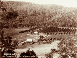 Orchard at Mount Sylvia, circa 1898 | |||||||||||||||
 Mount Sylvia | |||||||||||||||
| Coordinates | 27°44′17″S 152°13′35″E / 27.7380°S 152.2263°ECoordinates: 27°44′17″S 152°13′35″E / 27.7380°S 152.2263°E | ||||||||||||||
| Postcode(s) | 4343 | ||||||||||||||
| Area | 46.6 km2 (18.0 sq mi) | ||||||||||||||
| LGA(s) | Lockyer Valley Region | ||||||||||||||
| State electorate(s) | Lockyer | ||||||||||||||
| Federal Division(s) | Wright | ||||||||||||||
| |||||||||||||||
Mount Sylvia is a locality in the Lockyer Valley Region, Queensland, Australia.[1]
History
Mount Sylvia Provisional School opened on 13 April 1885, becoming Mount Sylvia State School on 1 January 1909.[2]
Education
Mount Sylvia State School is a government co-educational primary school (P-6) at 6 Left Hand Branch Road. In 2016, the school had an enrolment of 46 students with 4 teachers (2 full-time equivalent) and 4 non-teaching staff (2 full-time equivalent).[3]
References
- ↑ "Mount Sylvia - locality in Lockyer Valley Region (entry 44980)". Queensland Place Names. Queensland Government. Retrieved 12 September 2017.
- ↑ Queensland Family History Society (2010), Queensland schools past and present (Version 1.01 ed.), Queensland Family History Society, ISBN 978-1-921171-26-0
- ↑ "Annual Report 2016" (PDF). Mount Sylvia State School. Archived (PDF) from the original on 12 September 2017. Retrieved 12 September 2017.
Further reading
- Mount Sylvia State School, Mount Sylvia State School : 125 years, 1885 - 2010, retrieved 12 September 2017
External links
![]()
This article is issued from
Wikipedia.
The text is licensed under Creative Commons - Attribution - Sharealike.
Additional terms may apply for the media files.