Lake Wivenhoe
| Lake Wivenhoe Queensland | |
|---|---|
 Lake Wivenhoe, Queensland | |
| Postcode(s) | 4312 |
| LGA(s) | Somerset Region |
| State electorate(s) | Nanango |
| Federal Division(s) | Blair |
Lake Wivenhoe is a lake formed by the Wivenhoe Dam and the surrounding locality in the Somerset Region, Queensland, Australia.[1][2]
Geography
The locality includes the dam wall and associated water management infrastructure at the south, the lake created by the dam, sections of the Brisbane and Stanley Rivers as they flow into the lake from the north and a narrow strip of land around the dam, the lake and river the sections. The lake's boundaries are very irregular and this is reflected in the very irregular boundaries of the locality. The locality is entirely set aside for water management purposes.[3]
Due to its unusual shape, Lake Wivenhoe has many adjacent localities including (commencing from the dam wall in the south and proceeding clockwise: Wivenhoe Pocket, Patrick Estate, Wivenhoe Hill, Coominya, Moombra, Glen Esk, Murrumba, Coal Creek, Caboonbah, Mount Beppo, Cressbrook, Lower Cressbrook, Cooeeimbardi, Somerset Dam, Crossdale, Bryden, Dundas, and Split Yard Creek.[3]
The Brisbane Valley Highway passes through the south of the locality as it travels across the top of the dam wall.[3]
History
The name Wivenhoe comes from the name of the pastoral property established in 1864 by Edmund Blucher Uhr, which took its name from the town of Wivenhoe in Essex, England.[1]
Heritage listings
Lake Wivenhoe has a number of heritage-listed sites, including:
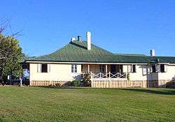
- Esk-Kilcoy Road: Caboonbah Homestead[4]
Amenities
Although it is not a populated area, Lake Wivenhoe offers a range of outdoor recreational facilities for camping, picnics, swimming, fishing and water sports.
Camping sites are provided at Captain Logan and Lumley Hill Areas.[5] The managed camping facilities at Captain Logan Camp include hot showers, barbecues and toilets, and are adjacent to playgrounds and a boat ramp at Logan Inlet. Cormorant Bay, Hamon Cove and Spillway Common also have facilities for picnic.[5]
A stocked impoundment permit is required to fish in the dam.[6] Swimming is permitted and camp sites have been established. Electric and non-powered boating with a permit is allowed, but domestic animals are banned.[7]
The heritage-listed Caboonbah Homestead was located on to the north-west of the lake (near but not within the locality of Caboonbah) where it was a tourist attraction operated by the Brisbane Valley Historical Society until the homestead burned down in 2009.[8]
References
- 1 2 "Lake Wivenhoe (entry 37792)". Queensland Place Names. Queensland Government. Retrieved 4 July 2015.
- ↑ "Lake Wivenhoe (entry 44880)". Queensland Place Names. Queensland Government. Retrieved 4 July 2015.
- 1 2 3 "Queensland Globe". State of Queensland. Retrieved 4 July 2015.
- ↑ "Caboonbah Homestead (entry 601139)". Queensland Heritage Register. Queensland Heritage Council. Retrieved 12 July 2013.
- 1 2 "Lakes – Somerset, Wivenhoe and Atkinson". Somerset Regional Council. Archived from the original on 22 January 2011. Retrieved 21 September 2010.
- ↑ "Do I need a permit to go fishing in a dam?". Department of Agriculture, Fisheries and Forestry. Queensland Government. 5 February 2013. Retrieved 5 July 2014.
- ↑ "Lake Wivenhoe". ourbrisbane.com. Brisbane City Council. Archived from the original on 14 April 2010. Retrieved 21 September 2010.
- ↑ Earley, David (11 May 2009). "Fire destroys Caboonbah Homestead". Courier-Mail. Retrieved 4 July 2015.